
Droughdool Mote


Cairn (Early Bronze Age), Folly (18th Century) - (20th Century), Ritual Mound (Late Neolithic)
Site Name Droughdool Mote
Classification Cairn (Early Bronze Age), Folly (18th Century) - (20th Century), Ritual Mound (Late Neolithic)
Alternative Name(s) Genoch Mains
Canmore ID 61278
Site Number NX15NW 6
NGR NX 14826 56869
NGR Description Centre
Datum OSGB36 - NGR
Permalink http://canmore.org.uk/site/61278


- Council Dumfries And Galloway
- Parish Old Luce
- Former Region Dumfries And Galloway
- Former District Wigtown
- Former County Wigtownshire
NX15NW 6 1482 5687.
(NX 1482 5687) Droughdool Mote (NR)
(Undated) annotation on OS map.
Motte (R W Feachem 1956): A round sandy hillock formed of angular stones and cobbles from the beach as exposed on the summit and at places on its flanks, with a diameter at base of 156' or thereby, rising to an elevation varying from 25' to 30' and with a level summit some 40' in diameter. It appears to have been erected on a slight natural eminence which projects somewhat beyond the base towards the east and west. At the base, passing around the north side, is a terrace some 10' in width. Watson erroneously places here the Fort of Rheged (the Mote of Drochdool is sometimes, incorrectly, called the Mote of Dunragit, for which see NX15NW 4). The Mote of Drochdool is an Anglo-Norman structure of the 12th century.
RCAHMS 1912; W J Watson 1926; R C Reid 1952.
As described by RCAHMS: the motte is known locally as Droughdool Mote.
Resurveyed at 1/2500.
Visited by OS (RD) 23 February 1968
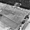
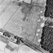
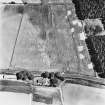
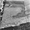
On level ground 1.2km ENE of Genoch Mains there is a prominent mound which is probably a motte. It appears to have been built on a natural knoll and now stands to a height of 10m on the NE; its roughly level summit measures about 12m in diameter. It is unlikely that a number of pits and gullies to the SE and E are related to the mound.
RCAHMS 1987, visited April 1986.
Note (19 December 2024)
This large mound is situated on low-lying ground north of Luce Bay, at about 10m above sea level. It is flat topped and oval on plan, measuring about 60m from NNE to SSW by about 50m and standing almost 10m high, with the summit having a diameter of about 12m. Excavations in 2002 (Thomas 2015) revealed that the mound largely dates to the late Neolithic period, with buried evidence of later activity on the summit of the mound in the form of an early Bronze Age round cairn and a modern folly.
The late Neolithic ritual mound was constructed on a natural sand dune rise and the sides were originally stepped. A sequence of Optically Stimulated Luminesce (OSL) dates places the initial construction and use of the mound into the third millennium BC. This indicates that the mound was broadly contemporary with the Dunragit enclosure (Canmore ID 78922). The entrance avenue of the middle ring of the enclosure is aligned on the mound and the mound commands extensive views across the Dunragit monumental complex (Canmore ID 78918). At this period the mound was situated on a narrow ridge jutting into Luce Bay (Smith et al. 2020, 756).
Excavation uncovered the remains of a round cairn, surviving as a low spread of stones bounded by a kerb and measuring about 8m in diameter. It was formed of a core of large, rounded, boulders beneath a mass of more angular stones. Two small flint scrapers and fragments of burnt bone were found within the body of the cairn. A scatter of stone from the cairn was found to have collapsed down the side of the mound, indicating that the cairn was originally quite tall and unstable. OSL dating shows that it had collapsed by about 1200BC.
The folly survives as the buried footings of a small stone building with a wooden floor and west-facing doorway. It measured about 2m from N to S by about 1.5m. Its footings cut through and disturbed the remains of the cairn. A concentration of 19th century bottle fragments and china sherds were found in and around the building and a small glass bottle with a scrap of paper within it was also recovered. A pencil written message on the paper indicates that the folly was demolished in 1908.
Information from HES Designations (K. Millican), 19 December 2024.
Note (4 March 2025)
The classification, location and period of this site record have been reviewed and changed from Motte (Medieval) to Ritual Mound (Late Neolithic); Cairn (Early Bronze Age); Folly (18th Century – 20th century) as part of record revision work carried out by HES Designations.
Information from HES Designations (K. Millican), 04 March 2025.

