|
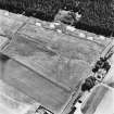
Photographs and Off-line Digital Images |
C 53088 |
RCAHMS Aerial Photography |
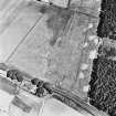
Dunragit, oblique aerial view, taken from the WSW, centred on a pair of linear cropmarks. Droughdool Motte is visible in the centre right of the photograph. |
4/8/1995 |
Item Level |
|
|
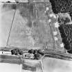
Photographs and Off-line Digital Images |
C 53089 |
RCAHMS Aerial Photography |
Dunragit, oblique aerial view, taken from the SSW, centred on a pair of linear cropmarks. Droughdool Motte is visible at the bottom edge of the photograph. |
4/8/1995 |
Item Level |
|
|
Photographs and Off-line Digital Images |
C 53093 |
RCAHMS Aerial Photography |
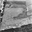
Dunragit, oblique aerial view, taken from the NNW, centred on a pair of linear cropmarks. Droughdool Motte is visible at the top edge of the photograph. |
4/8/1995 |
Item Level |
|
|
Photographs and Off-line Digital Images |
C 53094 |
RCAHMS Aerial Photography |
Dunragit, oblique aerial view, taken from the W, centred on a pair of linear cropmarks. Droughdool Motte is visible in the top right-hand corner of the photograph. |
4/8/1995 |
Item Level |
|
 |
Digital Files (Non-image) |
WP 003152 |
General Collection |
Radiocarbon Laboratory Certificate: SUERC-44834 (GU29715)
|
|
Item Level |
|
 |
On-line Digital Images |
DP 193989 |
RCAHMS Aerial Photography Digital |
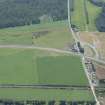
Oblique aerial view of the Dunragit bypass with Droughdool mound beyond, looking SSW. |
25/7/2014 |
Item Level |
|
 |
On-line Digital Images |
SC 1755022 |
RCAHMS Aerial Photography |
Dunragit, oblique aerial view, taken from the WSW, centred on a pair of linear cropmarks. Droughdool Motte is visible in the centre right of the photograph. |
4/8/1995 |
Item Level |
|
 |
On-line Digital Images |
SC 1755023 |
RCAHMS Aerial Photography |
Dunragit, oblique aerial view, taken from the SSW, centred on a pair of linear cropmarks. Droughdool Motte is visible at the bottom edge of the photograph. |
4/8/1995 |
Item Level |
|
 |
On-line Digital Images |
SC 1755027 |
RCAHMS Aerial Photography |
Dunragit, oblique aerial view, taken from the NNW, centred on a pair of linear cropmarks. Droughdool Motte is visible at the top edge of the photograph. |
4/8/1995 |
Item Level |
|
 |
On-line Digital Images |
SC 1755028 |
RCAHMS Aerial Photography |
Dunragit, oblique aerial view, taken from the W, centred on a pair of linear cropmarks. Droughdool Motte is visible in the top right-hand corner of the photograph. |
4/8/1995 |
Item Level |
|
 |
On-line Digital Images |
SC 2460197 |
Records of the Ordnance Survey, Southampton, Hampshire, England |
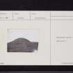
Droughdool Mote, NX15NW 6, Ordnance Survey index card, page number 2, Verso |
1958 |
Item Level |
|
 |
On-line Digital Images |
SC 2460198 |
Records of the Ordnance Survey, Southampton, Hampshire, England |
Droughdool Mote, NX15NW 6, Ordnance Survey index card, Recto |
1958 |
Item Level |
|
 |
On-line Digital Images |
SC 2460199 |
Records of the Ordnance Survey, Southampton, Hampshire, England |
Droughdool Mote, NX15NW 6, Ordnance Survey index card, page number 1, Recto |
1958 |
Item Level |
|
 |
On-line Digital Images |
SC 2460200 |
Records of the Ordnance Survey, Southampton, Hampshire, England |
Droughdool Mote, NX15NW 6, Ordnance Survey index card, page number 2, Recto |
1958 |
Item Level |
|
 |
On-line Digital Images |
SC 2460201 |
Records of the Ordnance Survey, Southampton, Hampshire, England |
Droughdool Mote, NX15NW 6, Ordnance Survey index card, Recto |
1958 |
Item Level |
|
 |
On-line Digital Images |
SC 2460202 |
Records of the Ordnance Survey, Southampton, Hampshire, England |
Droughdool Mote, NX15NW 6, Ordnance Survey index card, page number 1, Recto |
1958 |
Item Level |
|
|
All Other |
551 166/1/1 |
Records of the Ordnance Survey, Southampton, Hampshire, England |
Archaeological site card index ('495' cards) |
1947 |
Sub-Group Level |
|


