
Mote Hill, Glenluce


Earthwork (Period Unassigned)
Site Name Mote Hill, Glenluce
Classification Earthwork (Period Unassigned)
Alternative Name(s) Glenluce
Canmore ID 61154
Site Number NX15NE 12
NGR NX 1936 5733
Datum OSGB36 - NGR
Permalink http://canmore.org.uk/site/61154


- Council Dumfries And Galloway
- Parish Old Luce
- Former Region Dumfries And Galloway
- Former District Wigtown
- Former County Wigtownshire
NX15NE 12 1936 5733
(Name: NX 194 573) Mote Hill (NAT)
OS 6" map (1957)
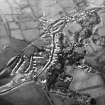
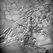
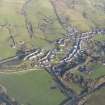
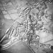
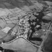
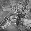
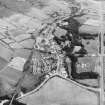
The Mote Hill is a natural hill which presents steep slopes, from 12 feet to 50 feet in height, in all directions except the E where it is linked by a narrow ridge to slightly higher ground. Although the top of the hill has been intensely cultivated in former times, vestiges of two ramparts can still be seen at the east end; the inner of these was no doubt once continuous round the margin of the summit area, enclosing an oval space measuring c.270 feet in length by 150 feet in width, while the outer rampart was probably only a detached segment affording additional protection.
The ramparts are not more than 18" high but have evidently been of substantial proportions, each of them measuring at least 20 feet in thickness at the base. A gap, 15 feet wide, in the centre of the surviving segment of the inner rampart may mark the position of the original entrance. The interior is featureless.
The plan and situation of this work suggest that it is likely to be medieval rather than prehistoric.
RCAHMS TS and plan 1955
NX 1936 5733. As described and planned by RCAHMS.
Surveyed at 1/2500.
Visited by OS (RD) 15 March 1968
This earthwork is situated on a steep-sided promontory at the W end of the village of Glenluce. It is now heavily eroded by cultivation but on the E traces of two ramparts with a medial ditch are visible, cutting off an area measuring 88m from WSW to ENE by 54m transversely.
RCAHMS 1987, visited (SH) October 1986.
RCAHMS Survey of Marginal Lands
Field Visit (23 June 1955)
This site was included within the RCAHMS Marginal Land Survey (1950-1962), an unpublished rescue project. Site descriptions, organised by county, are available to view online - see the searchable PDF in 'Digital Items'. These vary from short notes, to lengthy and full descriptions. Contemporary plane-table surveys and inked drawings, where available, can be viewed online in most cases - see 'Digital Images'. The original typecripts, notebooks and drawings can also be viewed in the RCAHMS search room.
Information from RCAHMS (GFG) 19 July 2013.
Reference (1957)
This site is noted in the ‘List of monuments discovered during the survey of marginal land (1951-5)’ (RCAHMS 1957, xiv-xviii).
Information from RCAHMS (GFG), 24 October 2012.
Note (20 December 2013 - 23 May 2016)
This fort occupies the W end of ridge overlooking a relatively narrow gap through which the Water of Luce debouches onto the coastal plain. Oval on plan, it measures about 88m from E to W by 54m internally, though it is now heavily ploughed down and little trace of it is visible on the ground. Nevertheless, cropmarks have revealed no fewer than three ditches cutting across the spine of the ridge, forming a belt of defences on this side at least 40m deep, in which the innermost ditch is in the order of 10m in breadth. To what extent these defences were carried round the rest of the ridge is unclear; they would have been unnecessary around the southern flank, where the ground drops steeply to the haughland, but the inner rampart seems to have extended along the gentler N flank, where the cropmarks suggest there may also have been an entrance.
Information from An Atlas of Hillforts of Great Britain and Ireland – 23 May 2016. Atlas of Hillforts SC0203

