
Scheduled Maintenance
Please be advised that this website will undergo scheduled maintenance on the following dates: •
Tuesday 3rd December 11:00-15:00
During these times, some services may be temporarily unavailable. We apologise for any inconvenience this may cause.
The Dounan


Promontory Fort (Period Unassigned)
Site Name The Dounan
Classification Promontory Fort (Period Unassigned)
Canmore ID 60613
Site Number NX05SW 12
NGR NX 0190 5230
Datum OSGB36 - NGR
Permalink http://canmore.org.uk/site/60613


- Council Dumfries And Galloway
- Parish Stoneykirk
- Former Region Dumfries And Galloway
- Former District Wigtown
- Former County Wigtownshire
NX05SW 12 0190 5230.
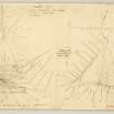
(NX 019 523) Fort - The Dounan: A small high point of land fortified by drawing a rampart and ditch in a slight curve across the landward end. The site has long been cultivated and in consequence the rampart is merely a faint swelling in the ground, some 25' thick, while the ditch is only perceptible near the S margin of the promontory where it is c.15' wide. There are two gaps in the rampart, one near the centre and the other at the N end, either of which may mark the original entrance. The interior, bounded by 200' high cliffs on the NW and S, measures 110' by 105'; apart from a modern turf dyke along the NW side, it shows no trace of structures.
RCAHMS Marginal Lands Survey TS., visited 1 June 1955
The scant remains of this promontory fort have now been completely ploughed out. It was centred on NX 0190 5230.
Visited by OS (WDJ) 4 September 1970
Nothing is now visible of an earthwork which cut off the steep-sided promontory knwon as the Dounan. By 1955 (RCAHMS 1955) the bank had been reduced to a slight swelling about 7m thick and the external ditch, which was about 4.6m broad, was only visible at the S end. There were two gaps in the bank one midway along its length, and the other at the NW end. The interior measured 33.5m from NE to SW by 27.5m transversely.
Name Book; RCAHMS Survey of Marginal Lands; RCAHMS 1985, visited (SH) August 1984.
Field Visit (1 June 1955)
This site was included within the RCAHMS Marginal Land Survey (1950-1962), an unpublished rescue project. Site descriptions, organised by county, are available to view online - see the searchable PDF in 'Digital Items'. These vary from short notes, to lengthy and full descriptions. Contemporary plane-table surveys and inked drawings, where available, can be viewed online in most cases - see 'Digital Images'. The original typecripts, notebooks and drawings can also be viewed in the RCAHMS search room.
Information from RCAHMS (GFG) 19 July 2013.
Reference (1957)
This site is noted in the ‘List of monuments discovered during the survey of marginal land (1951-5)’ (RCAHMS 1957, xiv-xviii).
Information from RCAHMS (GFG), 24 October 2012.
Note (20 December 2013 - 23 May 2016)
This small fort occupies a promontory on the coastal escarpment, which hereabouts falls away sharply on the W some 60m to the sea below. First noted by RCAHMS in 1955, when it comprised a single ploughed-down earthen rampart with an external ditch, it had been almost obliterated by continuing cultivation by the time the OS visited in 1970, and no traces of it were observed by RCAHMS in 1984. In 1955 the rampart was spread some 7m thick and the ditch was 4.6m broad, cutting off an area measuring 33m from NE to SW by 27m transversely (0.05ha). The position of the entrance is uncertain.
Information from An Atlas of Hillforts of Great Britain and Ireland – 23 May 2016. Atlas of Hillforts SC0188

