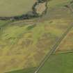
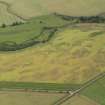
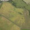
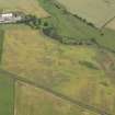
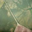
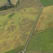
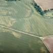
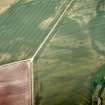
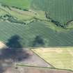
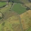
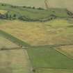
Accessibility

Font Size

100% 150% 200%

Background Colour

Default Contrast
Close Reset

East Reston

Enclosure (Period Unassigned)

Site Name East Reston

Classification Enclosure (Period Unassigned)

Canmore ID 60243

Site Number NT96SW 52

NGR NT 90888 60741

Datum OSGB36 - NGR

Permalink http://canmore.org.uk/site/60243

Ordnance Survey licence number AC0000807262. All rights reserved.
Canmore Disclaimer. © Bluesky International Limited 2025. Public Sector Viewing Terms

Toggle Aerial | View on large map

Digital Images

Administrative Areas

  • Council Scottish Borders, The
  • Parish Coldingham
  • Former Region Borders
  • Former District Berwickshire
  • Former County Berwickshire

Archaeology Notes

NT96SW 52 NT 90888 60741

NT 9088 6073. Cropmarks reveal two ditches, each up to 1.5m broad, enclosing a triangular area S of the Eye Water opposite the fort described on NT96SW 6. There are gaps on the SW and W, and possible traces of disturbance within the interior.

RCAHMS 1980.

Activities

Aerial Photography (3 July 2003)

Sbc Note

Visibility: This site is visible as a cropmark.

Information from Scottish Borders Council

References

MyCanmore Image Contributions


Contribute an Image

MyCanmore Text Contributions