
Burnmouth Harbour


Harbour (19th Century)
Site Name Burnmouth Harbour
Classification Harbour (19th Century)
Alternative Name(s) Lower Burnmouth; North Sea
Canmore ID 60186
Site Number NT96SE 8
NGR NT 95881 60948
Datum OSGB36 - NGR
Permalink http://canmore.org.uk/site/60186


- Council Scottish Borders, The
- Parish Ayton
- Former Region Borders
- Former District Berwickshire
- Former County Berwickshire
NT96SE 8 95881 60948
For (associated) stores at NT 96010 60819, see NT96SE 15.
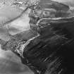
(Location cited as NT 958 610). Burnmouth Harbour, rebuilt 1879. A harbour of enclosure made by a substantial pier and a breakwater. Inside the harbour, a straight pier projecting from the main pier and an L-plan pier projecting from the shore form an inner basin.
J R Hume 1976.
Sbc Note (15 April 2016)
Visibility: Standing structure or monument.
Information from Scottish Borders Council

