
Pricing Change
New pricing for orders of material from this site will come into place shortly. Charges for supply of digital images, digitisation on demand, prints and licensing will be altered.
Habchester


Fort (Prehistoric)
Site Name Habchester
Classification Fort (Prehistoric)
Alternative Name(s) Bastleridge
Canmore ID 60069
Site Number NT95NW 4
NGR NT 9442 5881
Datum OSGB36 - NGR
Permalink http://canmore.org.uk/site/60069


- Council Scottish Borders, The
- Parish Mordington
- Former Region Borders
- Former District Berwickshire
- Former County Berwickshire
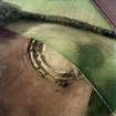
The Iron Age fort at Habchester was defended by two ramparts accompanied by external ditches. A field wall crosses the site and, to the NW of it, the ramparts have been levelled by ploughing, while to the SE they are relatively well preserved.
Information from RCAHMS (SC) 31 July 2007
NT95NW 4 9442 5881.
(NT 9444 5877). Habchester (NAT)
Hill Fort (NR.) (Remains of)
OS 6"map, (1957).
This oval fort measures 380' by 270' within two bold ramparts with external ditches. The NW sector has been ploughed away, but at the surviving entrance in the NE, the ramparts join round the head of the inner ditch. The NW sector of the defences is represented by the crest of a natural steep scarp, and it is probable that, in its original state, the fort would have been bounded on this side by only the inner rampart. Another feature is a quarry ditch at the inner foot of the remaining part of the inner rampart.
R W Feachem 1963; RCAHMS 1915, visited 1908.
A fort as described and planned.
Resurveyed at 1/2500.
Visited by OS (JFC) 24 November 1954 and (RD) 13 August 1970.
Listed.
RCAHMS 1980.
This oval fort is visible on vertical air photographs (106G/Scot/UK 15, 5265-5266, flown 15 April 1946 and OS 70 366, 140-141, flown 19 September 1970), which clearly show the ramparts with external ditches. The surviving remains of the NW sector are also just visible in the images from the spring and autumn.
Information from RCAHMS (DE), March 2006
Field Visit (4 August 1908)
270. Fort, Habchester.
Situated on the west end of Lamberton Moor, 697 feet above sea-level and about 11 miles south-east of Ayton Church, is an oval fort (fig. 146 [DP 229124]) with its longest axis north-east and south-west, of which the north half has been entirely obliterated. The defences consist of two high, narrow-crested ramparts, with an intervening ditch and another ditch to the outside measuring, from the crest of the innermost rampart to the top of the counterscarp of the outer ditch, 78 feet across. The crest of the innermost rampart is 5 feet above the level of the interior and 12 feet above the bottom of the intermediate ditch, while the crest of the scarp of the outermost rampart is 9 feet 6 inches above the bottom of the outer ditch, and that of the counterscarp 6 feet 6 inches (fig. 147 [SC1096822]). In rear of the inner rampart is a zone, about 12 feet wide, of low mounds and hollows of irregular shapes, beyond which lies a continuous depression. The entrance has been at the east end, where the two ramparts conjoin. Along its longest axis the fort has measured in the interior some300 feet. The ramparts appear to be of earth and stone.
See Antiquaries, xxix. p. 169 (illus.); Carr's Coldingham, p. 7; Christison, p. 142.
RCAHMS 1915, visited 4th August 1908.
OS Map: Ber., xii. SW.
Field Visit (1908)
This oval fort measures 380' by 270' within two bold ramparts with external ditches. The NW sector has been ploughed away, but at the surviving entrance in the NE, the ramparts join round the head of the inner ditch. The NW sector of the defences is represented by the crest of a natural steep scarp, and it is probable that, in its original state, the fort would have been bounded on this side by only the inner rampart. Another feature is a quarry ditch at the inner foot of the remaining part of the inner rampart.
R W Feachem 1963; RCAHMS 1915, visited 1908.
Field Visit (24 November 1954)
A fort as described and planned.
Resurveyed at 1/2500.
Field Visit (13 August 1970)
A fort as described and planned.
Resurveyed at 1/2500.
Infrared Line Scan (1995)
Note (22 February 2016 - 30 May 2016)
This fort is situated on the NW end of a broad ridge which terminates in a steep escarpment and provides a commanding prospect of the country from Eyemouth on the coast to the N round to Foulden on the SSW. It lies on the parish boundary between Ayton and Mordington, which has evidently also served as a property boundary, leading to widely different levels of preservation to either side, and while the defences in Mordington on the SE of the boundary are amongst the best preserved in the whole of Berwickshire, those on the escarpment on the NW have been virtually obliterated. Nevertheless, the fort has been oval on plan, measuring 100m from NE to SW by 80m transversely (0.63ha) within the innermost rampart, though in the surviving sector this is accompanied by an internal quarry scoop some 8m in breadth by 0.5m in depth, and there are also slight traces of a raised lip along its inner scarp. Around the SE half the defences comprise twin ramparts with external ditches about 6m in breadth and an outer counterscarp bank; while the inner rampart measures over 8m in thickness and still stands up to 3.2m above the inner ditch, the middle rampart is about 6m in thickness and rises 2.3m above the outer ditch; the outer bank on the counterscarp of the outer ditch is minor by comparison, measuring no more than 2.3m in thickness by 0.5m in height. Together they form a belt about 29m deep, and though this is the most accessible side, there is no reason to believe that the defences were any less round the NW, where the line of only the inner rampart and its ditch can be traced on the ground with any confidence. An entrance on the NE with traces of a worn hollow riding up the slope into the interior preserves evidence of the innermost and middle ramparts returning to unite around the terminal of the ditch on the SE side, forming a bank up to 4m thick by 1m high flanking the entrance way, which is itself about 4.8m wide; there are also possible traces of an opposed entrance in the ploughed down sector on the SW. The greater part of the interior has been under plough and there is no evidence of any internal structures.
Information from An Atlas of Hillforts of Great Britain and Ireland – 30 May 2016. Atlas of Hillforts SC4153
Sbc Note
Visibility: This is an upstanding earthwork or monument.
Information from Scottish Borders Council

