|
Photographs and Off-line Digital Images |
C 46899 CN |
RCAHMS Aerial Photography |
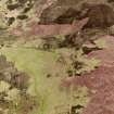
Cnoc Bad a' Chrasgaidh, oblique aerial view, taken from the NE, centred on a township. Small cairns and a hut-circle are visible in top half of the photograph, and hut-circles are shown in the bottom right-hand corner. |
23/6/1995 |
Item Level |
|
 |
On-line Digital Images |
SC 1693199 |
RCAHMS Aerial Photography |
Cnoc Bad a' Chrasgaidh, oblique aerial view, taken from the NE, centred on a township. Small cairns and a hut-circle are visible in top half of the photograph, and hut-circles are shown in the bottom right-hand corner. |
23/6/1995 |
Item Level |
|
 |
On-line Digital Images |
SC 2348614 |
Records of the Ordnance Survey, Southampton, Hampshire, England |
Cnoc Bad A Chrasgaidh, NC70SE 38, Ordnance Survey index card, page number 1, Recto |
c. 1958 |
Item Level |
|
 |
On-line Digital Images |
SC 2348615 |
Records of the Ordnance Survey, Southampton, Hampshire, England |
Cnoc Bad A Chrasgaidh, NC70SE 38, Ordnance Survey index card, page number 2, Verso |
c. 1958 |
Item Level |
|
|
All Other |
551 166/1/1 |
Records of the Ordnance Survey, Southampton, Hampshire, England |
Archaeological site card index ('495' cards) |
1947 |
Sub-Group Level |
|


