 |
On-line Digital Images |
SC 1692926 |
RCAHMS Aerial Photography |
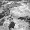
Breackue, Cnoc Dubh, oblique aerial view, taken from the NW, showing an area with small cairns and a trackway, a hut-circle and small cairns, as well as an enclosure, a hut and burnt mound in the centre of the photograph. An area with small cairns and a farmstead is visible in the upper left-hand corner. |
13/6/1995 |
Item Level |
|
 |
On-line Digital Images |
SC 1906995 |
Papers of James Sloan Bone, landscape historian, Inverness, Highland, Scotland |
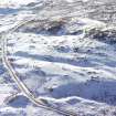
An oblique aerial view of Cnoc Dubh, East Langwell, Rogart, Sutherland, looking NE. |
2001 |
Item Level |
|
 |
On-line Digital Images |
SC 1945715 |
Papers of James Sloan Bone, landscape historian, Inverness, Highland, Scotland |
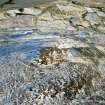
Aerial view of Cnoc Dubh hut circles & cairnfield, East Langwell, Strath Fleet, E Sutherland, looking SSE. |
2000 |
Item Level |
|
 |
On-line Digital Images |
SC 1945717 |
Papers of James Sloan Bone, landscape historian, Inverness, Highland, Scotland |
Aerial view of Cnoc Dubh hut circles & cairnfield, East Langwell, Strath Fleet, E Sutherland, looking WSW. |
2000 |
Item Level |
|
 |
On-line Digital Images |
SC 2348547 |
Records of the Ordnance Survey, Southampton, Hampshire, England |
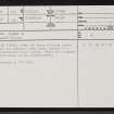
Cnoc Dubh, NC70NW 57, Ordnance Survey index card, page number 1, Recto |
1958 |
Item Level |
|


