
Glen Cottage


Fort (Iron Age)
Site Name Glen Cottage
Classification Fort (Iron Age)
Alternative Name(s) Dryburn
Canmore ID 58911
Site Number NT77SW 1
NGR NT 70470 74292
NGR Description Centre
Datum OSGB36 - NGR
Permalink http://canmore.org.uk/site/58911


- Council East Lothian
- Parish Dunbar
- Former Region Lothian
- Former District East Lothian
- Former County East Lothian
NT77SW 1 70466 74279.
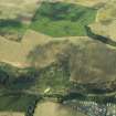
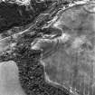
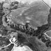
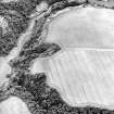
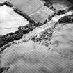
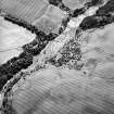
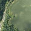
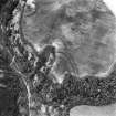
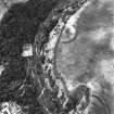
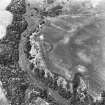
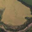
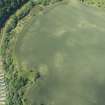
(NT 7049 7429) A semi-circular crop-mark is visible on air photographs (106G/Scot/UK121: 3425-6, flown 1946).
(Undated) information in NMRS.
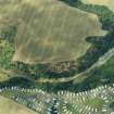
Ploughing has destroyed all traces of this earthwork. The S side of the site is formed by precipitous natural slopes, and although it is overlooked by higher ground to the N, it occupies a fairly good defensive position and could have been a small fort.
Visited by OS (WDJ) 28 March 1966
(NT 7049 7429) Earthwork (NR) (site of)
OS 6" map (1971)
Additional air photographs have been taken in 1976 (listed as an enclosure in RCAHMS catalogues).
(Undated) information in NMRS.
Scheduled as Glen Cottage, enclosure.
Information from Historic Scotland, scheduling document dated 22 November 1993.
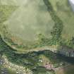
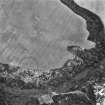
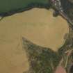
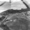
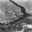
This roughly circular settlement, which is situated on sloping ground to the N side of the Dry Burn, was first recorded as cropmarks on vertical aerial photographs taken in 1946 (RAF 106G/SCOT/UK 121; 3425-6) and has since been regularly recorded on oblique aerial photographs (RCAHMSAP and CUCAP). The enclosure ditch is visible in an arc on the N, while to the S the ground falls steeply to the Dry Burn, and the interior of the settlement may have measured at least 40m from E to W.
Information from RCAHMS (MMB) 12 April 2005
Note (7 January 2016 - 1 June 2016)
This small fort or fortified settlement is situated on the lip of the steep escarpment dropping down on the N into the gorge occupied by the Dry Burn. D-shaped on plan, it measures 55m from ENE to WSW along the lip of the escarpment by a little over 40m transversely within an arc of ditch some 7m in breadth (0.18ha), and allowing for the presence of an internal rampart the interior extended to about 0.13ha. Apart from an irregular dark macula, the interior is featureless, but there is a broad entrance causeway on the WSW.
Information from An Atlas of Hillforts of Great Britain and Ireland – 01 June 2016. Atlas of Hillforts SC3925
Aerial Photographic Transcription (8 February 2019)
An interpretative transcription, or mapping, of information on oblique aerial photographs was produced on 8 February 2019.
Note (10 June 2023)
The location, classification and period of this site have been reviewed and changed from SETTLEMENT (PERIOD UNASSIGNED).

