
Following the launch of trove.scot in February 2025 we are now planning the retiral of some of our webservices. Canmore will be switched off on 24th June 2025. Information about the closure can be found on the HES website: Retiral of HES web services | Historic Environment Scotland
Inchomnie


Field System (Prehistoric), Hut Circle (Prehistoric)
Site Name Inchomnie
Classification Field System (Prehistoric), Hut Circle (Prehistoric)
Canmore ID 5888
Site Number NC70NW 49
NGR NC 7437 0623
Datum OSGB36 - NGR
Permalink http://canmore.org.uk/site/5888


- Council Highland
- Parish Rogart
- Former Region Highland
- Former District Sutherland
- Former County Sutherland
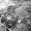
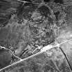
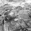
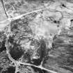
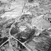
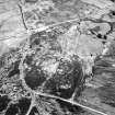
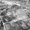
NC70NW 49 7437 0623.
(NC 7437 0623) Hut Circle (NR) (NC 741 064) Field System (NR)
OS 25" map, (1967)
A newly located hut circle and numerous field clearance heaps.
Surveyed at 1:2500.
Visited by OS (N K B) 24 February 1966.
A hut circle on a moorland ridge accompanied by a field system. The hut measures 13.0 by 11.5m over a wall best distinguished in intermittent outer-facing slabs; the entrance is in the S, the line of the main axis. The field system comprises numerous stone clearance heaps, spaced from 5.0 to 20.0m apart, with traces of lynchets; a plot 25.0 by 10.0m was noted, and, WNW of the hut, a stretch of banking. 150.0m to the SE are several more stone clearance heaps.
Revised at 1/2500.
Visited by OS (J M) 9 April 1981.

