
East Barns


Chimney (Mid 19th Century), Farmhouse (Mid 19th Century), Farmstead (Mid 19th Century)
Site Name East Barns
Classification Chimney (Mid 19th Century), Farmhouse (Mid 19th Century), Farmstead (Mid 19th Century)
Canmore ID 58820
Site Number NT77NW 34
NGR NT 71717 76208
NGR Description Centred on NT 71717 76208
Datum OSGB36 - NGR
Permalink http://canmore.org.uk/site/58820


- Council East Lothian
- Parish Dunbar
- Former Region Lothian
- Former District East Lothian
- Former County East Lothian
NT77NW 34 Centred on NT 71717 76208
NT77NW 34 7171 7622.
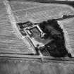
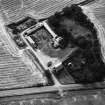
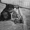
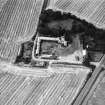
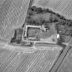
East Barns farmsteading has a plain circular-section brick chimney with single-storey rubble engine and boiler houses (location cited as NT771762).
J R Hume 1976.
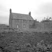
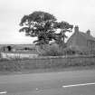
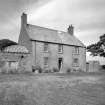
See site NT77NW site 40 for farm house 'Grieves House'.
Standing Building Recording (8 April 2013 - 31 October 2013)
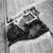
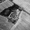
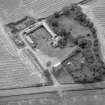
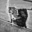
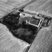
NT 71691 76256 A programme of archaeological work was undertaken, 8 April – 31 October 2013, on the large farm steading at East Barns prior to its demolition and the commencement of quarrying. The site has been occupied for hundreds of years with the remains of the steading dating to the late 18th or early 19th century. The majority of the steading, including the central cattle yards, had been demolished and most of the remaining barns had been derelict for 30+ years. Many of the roofs had collapsed rendering the buildings inaccessible. A measured, written and photographic survey was produced.
After the demolition of the remaining buildings an evaluation was carried out, in September 2013, which aimed to identify any remains of the earlier 18th-century farm and former late 19th-century country house. No earlier farm buildings were identified; however, the foundations of the country house to the W of the site, which was demolished in the 1980s, were located. A larger trench was opened over the foundations and remains recorded.
Archive: RCAHMS
Funder: Lafarge Cement UK Ltd
Diana Sproat and Rob Engl, AOC Archaeology Group, 2013
(Source: DES)
Standing Building Recording (8 April 2013 - 30 April 2013)
AOC Archaeology was commissioned by Lafarge Cement UK to undertake an historic building survey of the former farm steading at East Barns.
By the mid-19th century the historic mapping shows a very large planned farmsteading which was in use up until the 1980s, after which time it was partially demolished. Prior to its demolition in 2013, the grieve's house, main entrance, stables, cart shed, engine room and chimney and a few other barns still remained, although were largely inaccessible due to collapsed roofs.
Information from OASIS ID: aocarcha1-151556 (Gemma Hudson) 2013.
Archaeological Evaluation (21 October 2013 - 1 November 2013)
AOC Archaeology was commissioned by Lafarge Cement UK Ltd to undertake an historic building survey on the former farm steading at East Barns to the south of the town of Dunbar in East Lothian. Following the demolition of the remaining buildings, an archaeological evaluation equalling 500 linear metres was undertaken as well as an excavation of the old farmhouse once it was uncovered as part of the evaluation. These works were part of the planning condition on the part-listed steading prior to the complete removal of the site for quarrying.
Information from OASIS ID: aocarcha1-163704 (R Engl) 2013
External Reference (1 February 2014)
East Barnes Steading building was demolished in 2013.
Information from Dr Catherine Iliffe via letter dated 1/2/14.

