
Blackerstone


Cairn(S) (Prehistoric)(Possible)
Site Name Blackerstone
Classification Cairn(S) (Prehistoric)(Possible)
Canmore ID 58766
Site Number NT76SE 16
NGR NT 784 612
NGR Description NT c. 784 612
Datum OSGB36 - NGR
Permalink http://canmore.org.uk/site/58766


- Council Scottish Borders, The
- Parish Abbey St Bathans
- Former Region Borders
- Former District Berwickshire
- Former County Berwickshire
NT76SE 16 784 612.
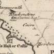
(Approximately NT 784 612) Two cairns, shown on Armstrong's map to the south of the Duns - Cockburnspath road, 1000 to 1200 yds east of Blackerstone, are now untraceable.
J H Craw 1923; A and sons Armstrong 1771.
No traces of these cairns are visible in the area indicated.
Visited by OS(JFC) 8 December 1954.
Field Visit (November 1979)
Blackerstone NT c. 784 611 NT76SE 16
Nothing is visible of two cairns recorded on Armstrong's Map of Berwickshire about 900m ESE of Blackerstone farm.
RCAHMS 1980, visited November 1979.
(Armstrong 1771).
Sbc Note (21 March 2016)
Visibility: This was the site of an archaeological monument, which may no longer be visible.
Information from Scottish Borders Council
Previously also listed under duplicate site NT96SW 510 -CANCELLED. HES (LCK) 11.6.2024
Note (6 January 2020)
The location, classification and period of this site have been reviewed.

