
Ardichoncherr


Cairnfield (Prehistoric)
Site Name Ardichoncherr
Classification Cairnfield (Prehistoric)
Canmore ID 5851
Site Number NC70NW 15
NGR NC 7030 0525
Datum OSGB36 - NGR
Permalink http://canmore.org.uk/site/5851


- Council Highland
- Parish Rogart
- Former Region Highland
- Former District Sutherland
- Former County Sutherland
NC70NW 15 703 052.
(Area NC 703 052) Tumuli (NR)
OS 6"map, Sutherland, 2nd ed., (1907)
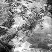
On the W slope of Ardaigh Chonachair, about 3/4 mile NE of Blarich, and along the ridge, are numerous small mounds a few of which have been excavated, but no cists are exposed.
About a mile N of Tressady Lodge is a mound or cairn, overgrown with vegetation, measuring 32ft in diameter and about 5 1/2ft high. A number of small mounds lie around it.
RCAHMS 1911.
These stony mounds, including the large mound described by the RCAHMS, would appear to be field clearance heaps, but although the area is comparatively clear and is suitable for cultivation, there is no definite evidence for this, so the mounds could either be cairns or clearance heaps. Similar scattered groups of mounds occur on the low hills to the S and W.
Visited by OS (N K B) 24 February 1966.
(NC 703 052) Cairns (NR) (six shown)
OS 1:10,000 map, (1970)
The mounds are of a type usually associated with hut circles. There are outlying similar mounds, particularly numerous to the WNW.
Visited by OS (J M) 20 May 1981.
Field Visit (20 June 1995)
There is an area of small cairns, measuring about 200m from ENE to WSW by 130m transversely, occupying the hilltop to the N of Ardnaconchery. The cairns measure up to 7m in diameter by 1.5m in height and extend downslope to the E, where an earthen bank runs roughly N to S along the edge of the wooded ground. The cairns, annotated 'Tumuli', are depicted on the 1st edition of the OS 6-inch map (Sutherlandshire 1878, Sheet 96).
(ROG95 811)
Visited by RCAHMS (PJD), 20 June 1995

