Accessibility

Font Size

100% 150% 200%

Background Colour

Default Contrast
Close Reset

Pennymuir

Temporary Camp(S) (Roman)

Site Name Pennymuir

Classification Temporary Camp(S) (Roman)

Alternative Name(s) Towford; Dere Street

Canmore ID 58106

Site Number NT71SE 5

NGR NT 75468 13955

NGR Description Centred NT 75468 13955

Datum OSGB36 - NGR

Permalink http://canmore.org.uk/site/58106

Ordnance Survey licence number AC0000807262. All rights reserved.
Canmore Disclaimer. © Bluesky International Limited 2025. Public Sector Viewing Terms

Toggle Aerial | View on large map

Digital Images

Oblique aerial view.
Oblique aerial view.Oblique aerial view centred on the remains of the Roman Temporary Camps and the linear earthwork at Pennymuir, looking SE.Oblique aerial view centred on the remains of the Roman Temporary Camps and the linear earthwork at Pennymuir, looking ESE.Oblique aerial view.Oblique aerial view.Oblique aerial view.Oblique aerial view.Oblique aerial view.Oblique aerial view.Pennymuir, oblique aerial view, taken from the SW, centred on Roman Temporary Camps and a linear earthwork. The course of 'Dere Street' is visible in the centre of the photograph.Pennymuir, oblique aerial view, taken from the NE, centred on Roman Temporary Camps, a linear earthwork and an area of rig. The course of 'Dere Street' is visible in the bottom half of the photograph.Oblique aerial view centred on the remains of Roman temporary camps, earthwork, sheepfolds, enclosure and rig, taken from the SSE.Oblique aerial view centred on the remains of Roman temporary camps, earthwork, sheepfolds and rig, taken from the ENE.Oblique aerial view centred on the remains of Roman temporary camps, earthwork, sheepfolds, enclosure and rig, taken from the NNE.Oblique aerial view.Oblique aerial view.Oblique aerial view.Pennymuir, NT71SE 5, Ordnance Survey index card, page number 1, RectoPennymuir, NT71SE 5, Ordnance Survey index card, page number 3, RectoOblique aerial view centred on the remains of the Roman Temporary Camps and the linear earthwork at Pennymuir, looking SSW.Oblique aerial view of Pennymuir, looking E.Oblique aerial view.Oblique aerial view.Oblique aerial view.Oblique aerial view.Oblique aerial view.Oblique aerial view.Oblique aerial view.Oblique aerial view.Oblique aerial view.Oblique aerial view.Pennymuir, oblique aerial view, taken from the ENE, centred on three Roman Temporary Camps, a linear earthwork and an area of rig. The course of 'Dere Street' is visible in the bottom half of the photograph.Pennymuir, oblique aerial view, taken from the NE, centred on three Roman Temporary Camps, a linear earthwork and an area of rig. The course of 'Dere Street' is visible in the bottom half of the photograph.Pennymuir, oblique aerial view, taken from the NE, centred on Roman Temporary Camps, a linear earthwork and an area of rig. The course of 'Dere Street' is visible in the bottom half of the photograph.Oblique aerial view centred on the remains of Roman temporary camps, earthwork, sheepfolds, enclosure and rig, taken from the NE.Oblique aerial view.Oblique aerial view.Oblique aerial view centred on the remains of the Roman Temporary Camps and the linear earthwork at Pennymuir, looking NNW.Oblique aerial view centred on the remains of the Roman Temporary Camps and the linear earthwork at Pennymuir, looking WNW.Oblique aerial view.Oblique aerial view.Oblique aerial view.Oblique aerial view.Oblique aerial view.Oblique aerial view.Pennymuir, oblique aerial view, taken from the SSW, centred on two Roman Temporary Camps and a linear earthwork. An area of rig and the course of 'Dere Street' are visible in the top right-hand corner of the photograph.Oblique aerial view centred on the remains of Roman temporary camps, earthwork, sheepfolds, enclosure and rig, taken from the SW.Oblique aerial view centred on the remains of Roman temporary camps, earthwork, sheepfolds, enclosure and rig, taken from the NNE.Oblique aerial view.Oblique aerial view.Pennymuir, NT71SE 5, Ordnance Survey index card, RectoPennymuir, NT71SE 5, Ordnance Survey index card, RectoOblique aerial view of Pennymuir Roman temporary camp.Oblique aerial view centred on the remains of the Roman Temporary Camps and the linear earthwork at Pennymuir, looking NW.Oblique aerial view centred on the remains of the Roman Temporary Camps and the linear earthwork at Pennymuir, looking WSW.Oblique aerial view centred on the remains of the Roman Temporary Camps and the linear earthwork at Pennymuir, looking SW.Oblique aerial view centred on the remains of the Roman Temporary Camps and the linear earthwork at Pennymuir, looking SSW.Oblique aerial view.Oblique aerial view.Oblique aerial view.Oblique aerial view.Oblique aerial view.Pennymuir, oblique aerial view, taken from the NW, centred on three Roman Temporary Camps and an area of rig. The course of 'Dere Street' is shown in the left half of the photograph.Pennymuir, oblique aerial view, taken from the WSW, centred on three Roman Temporary Camps, a linear earthwork and an area of rig. The course of 'Dere Street' is shown in the centre of the photograph.Oblique aerial view.Oblique aerial view.Oblique aerial view.Pennymuir, NT71SE 5, Ordnance Survey index card, page number 2, RectoPennymuir, NT71SE 5, Ordnance Survey index card, RectoOblique aerial view centred on the remains of the Roman Temporary Camps and the linear earthwork at Pennymuir, looking NW.Oblique aerial view centred on the remains of the Roman Temporary Camps and the linear earthwork at Pennymuir, looking ESE.General oblique aerial view centred on the remains of the Roman Temporary Camps and the linear earthwork at Pennymuir with the Kale Water, Hangingshaw Hill and Humblemoor Hill beyond, looking E.Oblique aerial view.Oblique aerial view.Oblique aerial view.Oblique aerial view.Pennymuir, oblique aerial view, taken from the NE, centred on two Roman Temporary Camps and a linear earthwork. An area of rig and the course of 'Dere Street' are visible in the bottom left-hand corner of the photograph.Pennymuir, oblique aerial view, taken from the SW, centred on Roman Temporary Camps, a linear earthwork and an area of rig. The course of 'Dere Street' is shown in the centre of the photograph.Oblique aerial view centred on the remains of Roman temporary camps, earthwork, sheepfolds, enclosure and rig, taken from the SW.Oblique aerial view centred on the remains of Roman temporary camps, earthwork, sheepfolds, enclosure and rig, taken from the NE.Pennymuir, NT71SE 5, Ordnance Survey index card, page number 1, RectoPennymuir, NT71SE 5, Ordnance Survey index card, page number 6, VersoPennymuir, NT71SE 5, Ordnance Survey index card, page number 7, RectoOblique aerial view centred on the remains of the Roman Temporary Camps and the linear earthwork at Pennymuir, looking NNW.Oblique aerial view centred on the remains of the Roman Temporary Camps and the linear earthwork at Pennymuir, looking NW.Oblique aerial view.Oblique aerial view.Oblique aerial view.Oblique aerial view.Oblique aerial view.Oblique aerial view.Oblique aerial view.Oblique aerial view.Oblique aerial view centred on the remains of Roman temporary camps, earthwork, sheepfolds and rig, taken from the ENE.Oblique aerial view.Pennymuir, NT71SE 5, Ordnance Survey index card, page number 4, VersoMap showing locations of the Pennymuir Roman temporary camps and Woden Law fort. 
Inventory no. 794.Oblique aerial view.Pennymuir, oblique aerial view, taken from the SSW, centred on two Roman Temporary Camps and a linear earthwork. An area of rig and the course of 'Dere Street' are visible in the top right-hand corner of the photograph.Pennymuir, oblique aerial view, taken from the SW, centred on Roman Temporary Camps, a linear earthwork and an area of rig. The course of 'Dere Street' is visible in the top right half of the photograph.

First 100 images shown. See the Collections panel (below) for a link to all digital images.

Administrative Areas

  • Council Scottish Borders, The
  • Parish Hownam
  • Former Region Borders
  • Former District Roxburgh
  • Former County Roxburghshire

Archaeology Notes

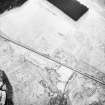
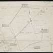
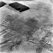
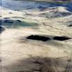
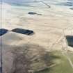
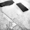
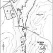
NT71SE 5.00 centred 75468 13955

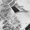
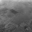
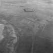
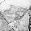
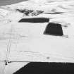
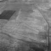
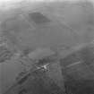
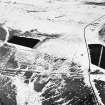
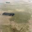
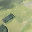
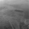
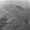
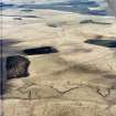
NT71SE 5.01 754 139 Roman Temporary Camp (Camp A)

NT71SE 5.02 756 138 Roman Temporary Camp (Camp B)

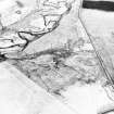
NT71SE 5.03 756 144 Roman Temporary Camp (Camp C)

NT71SE 5.04 757 139 Roman Temporary Camp (possible) (Camp D)

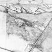
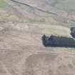
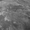
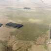
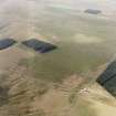
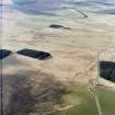
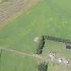
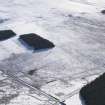
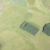
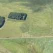
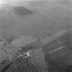
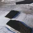
(Centred NT 755 140) Roman Camps (R)

OS 6" map, (1962).

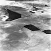
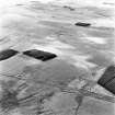
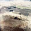
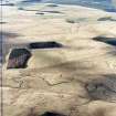
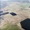
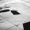
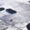
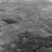
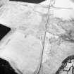
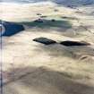
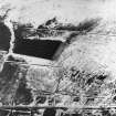
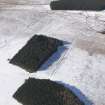
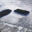
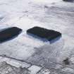
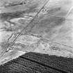
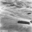
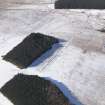
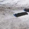
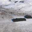
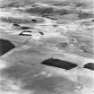
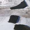
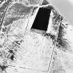
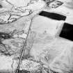
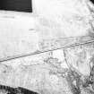
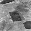
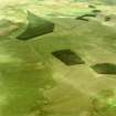
The best-preserved group of Roman temporary camps in Scotland is situated beside Dere Street at Pennymuir, a short distance N of Tow Ford where the Roman road crossed the Kale Water.

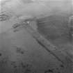
RCAHMS 1956, visited 1949

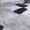
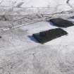
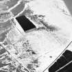
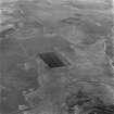
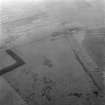
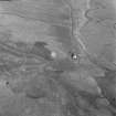
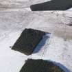
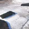
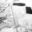
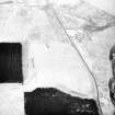
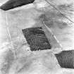
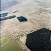
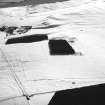
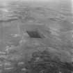
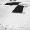
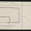
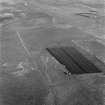
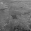
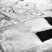
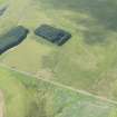
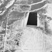
Centred NT 755 139. The remains of Camps 'A' and 'B' have been fully described above. As stated, the earthworks within and without the SW angle are later works: two sheepfolds and an old turf (? field) bank. Centred NT 757 144. The only remaining part of Camp 'C' is its W side, S of the Pennymuir road, traceable for some 150.0m as a very slight turf bank (2.0m broad and 0.2m high); the SW angle; and part of the S side running from this angle for some 100.0m when it is lost in field drains. A field drain marks part of the E and S sides of the camp. N of the road the field is under crop, and no trace of the bank was found here except for a mere suggestion of its continuance on the W side immediately N of the road. The entrances were not apparent.

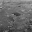
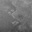
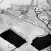
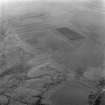
Centred NT 758 139. Parts of the N and E sides of Camp 'D', including the NE angle, are traceable as a low spread turf bank (5.0m broad and 0.1m - 0.3m high) with slight traces of an outer ditch. The N side can be traced for some 120.0m running up the hillside; and the E side for some 130.0m to the Kale Water. The earthwork has been badly cut up with drains.

Visited by OS (JLD) 11 August 1960.

Generally as described by previous authorities.

Visited by OS (RD) 30 May 1968.

No change to the previous information.

Visited by OS (BS) 8 September 1976.

Activities

Aerial Photography (1970)

Oblique aerial photographs

References

MyCanmore Image Contributions


Contribute an Image

MyCanmore Text Contributions