Accessibility

Font Size

100% 150% 200%

Background Colour

Default Contrast
Close Reset

Pennymuir

Linear Earthwork (Period Unassigned)

Site Name Pennymuir

Classification Linear Earthwork (Period Unassigned)

Canmore ID 58095

Site Number NT71SE 4

NGR NT 7539 1360

NGR Description NT 7539 1360 to NT 7524 1426

Datum OSGB36 - NGR

Permalink http://canmore.org.uk/site/58095

Ordnance Survey licence number AC0000807262. All rights reserved.
Canmore Disclaimer. © Bluesky International Limited 2025. Public Sector Viewing Terms

Toggle Aerial | View on large map

Digital Images

Oblique aerial view.
Oblique aerial view.Oblique aerial view centred on the remains of the Roman Temporary Camps and the linear earthwork at Pennymuir, looking SE.Oblique aerial view centred on the remains of the Roman Temporary Camps and the linear earthwork at Pennymuir, looking ESE.Oblique aerial view.Oblique aerial view.Oblique aerial view.Oblique aerial view.Pennymuir, oblique aerial view, taken from the SW, centred on Roman Temporary Camps and a linear earthwork. The course of 'Dere Street' is visible in the centre of the photograph.Pennymuir, oblique aerial view, taken from the NE, centred on Roman Temporary Camps, a linear earthwork and an area of rig. The course of 'Dere Street' is visible in the bottom half of the photograph.Oblique aerial view centred on the remains of Roman temporary camps, earthwork, sheepfolds, enclosure and rig, taken from the SSE.Oblique aerial view centred on the remains of Roman temporary camps, earthwork, sheepfolds and rig, taken from the ENE.Oblique aerial view centred on the remains of Roman temporary camps, earthwork, sheepfolds, enclosure and rig, taken from the NNE.Oblique aerial view centred on the remains of the Roman Temporary Camps and the linear earthwork at Pennymuir, looking SSW.Oblique aerial view of Pennymuir, looking E.Oblique aerial view.Oblique aerial view.Oblique aerial view.Oblique aerial view.Oblique aerial view.Oblique aerial view.Oblique aerial view.Pennymuir, oblique aerial view, taken from the ENE, centred on three Roman Temporary Camps, a linear earthwork and an area of rig. The course of 'Dere Street' is visible in the bottom half of the photograph.Pennymuir, oblique aerial view, taken from the NE, centred on three Roman Temporary Camps, a linear earthwork and an area of rig. The course of 'Dere Street' is visible in the bottom half of the photograph.Pennymuir, oblique aerial view, taken from the NE, centred on Roman Temporary Camps, a linear earthwork and an area of rig. The course of 'Dere Street' is visible in the bottom half of the photograph.Oblique aerial view centred on the remains of Roman temporary camps, earthwork, sheepfolds, enclosure and rig, taken from the NE.Pennymuir, NT71SE 4, Ordnance Survey index card, RectoOblique aerial view centred on the remains of the Roman Temporary Camps and the linear earthwork at Pennymuir, looking NNW.Oblique aerial view centred on the remains of the Roman Temporary Camps and the linear earthwork at Pennymuir, looking WNW.Oblique aerial view of Pennymuir, looking NE.Oblique aerial view.Pennymuir, oblique aerial view, taken from the SSW, centred on two Roman Temporary Camps and a linear earthwork. An area of rig and the course of 'Dere Street' are visible in the top right-hand corner of the photograph.Oblique aerial view centred on the remains of Roman temporary camps, earthwork, sheepfolds, enclosure and rig, taken from the SW.Oblique aerial view centred on the remains of Roman temporary camps, earthwork, sheepfolds, enclosure and rig, taken from the NNE.Pennymuir, NT71SE 4, Ordnance Survey index card, RectoOblique aerial view of Pennymuir Roman temporary camp.Oblique aerial view centred on the remains of the Roman Temporary Camps and the linear earthwork at Pennymuir, looking NW.Oblique aerial view centred on the remains of the Roman Temporary Camps and the linear earthwork at Pennymuir, looking WSW.Oblique aerial view centred on the remains of the Roman Temporary Camps and the linear earthwork at Pennymuir, looking SW.Oblique aerial view centred on the remains of the Roman Temporary Camps and the linear earthwork at Pennymuir, looking SSW.Oblique aerial view.Pennymuir, oblique aerial view, taken from the WSW, centred on three Roman Temporary Camps, a linear earthwork and an area of rig. The course of 'Dere Street' is shown in the centre of the photograph.Pennymuir, NT71SE 4, Ordnance Survey index card, page number 1, RectoOblique aerial view centred on the remains of the Roman Temporary Camps and the linear earthwork at Pennymuir, looking NW.Oblique aerial view centred on the remains of the Roman Temporary Camps and the linear earthwork at Pennymuir, looking ESE.General oblique aerial view centred on the remains of the Roman Temporary Camps and the linear earthwork at Pennymuir with the Kale Water, Hangingshaw Hill and Humblemoor Hill beyond, looking E.Oblique aerial view.Oblique aerial view.Oblique aerial view.Oblique aerial view.Pennymuir, oblique aerial view, taken from the NE, centred on two Roman Temporary Camps and a linear earthwork. An area of rig and the course of 'Dere Street' are visible in the bottom left-hand corner of the photograph.Pennymuir, oblique aerial view, taken from the SW, centred on Roman Temporary Camps, a linear earthwork and an area of rig. The course of 'Dere Street' is shown in the centre of the photograph.Oblique aerial view centred on the remains of Roman temporary camps, earthwork, sheepfolds, enclosure and rig, taken from the SW.Oblique aerial view centred on the remains of Roman temporary camps, earthwork, sheepfolds, enclosure and rig, taken from the NE.Pennymuir, NT71SE 4, Ordnance Survey index card, page number 2, VersoPennymuir, NT71SE 4, Ordnance Survey index card, RectoOblique aerial view centred on the remains of the Roman Temporary Camps and the linear earthwork at Pennymuir, looking NNW.Oblique aerial view centred on the remains of the Roman Temporary Camps and the linear earthwork at Pennymuir, looking NW.Oblique aerial view.Oblique aerial view.Oblique aerial view.Oblique aerial view.Oblique aerial view.Oblique aerial view.Oblique aerial view centred on the remains of Roman temporary camps, earthwork, sheepfolds and rig, taken from the ENE.Oblique aerial view.Pennymuir, oblique aerial view, taken from the SSW, centred on two Roman Temporary Camps and a linear earthwork. An area of rig and the course of 'Dere Street' are visible in the top right-hand corner of the photograph.Pennymuir, oblique aerial view, taken from the SW, centred on Roman Temporary Camps, a linear earthwork and an area of rig. The course of 'Dere Street' is visible in the top right half of the photograph.Oblique aerial view centred on the remains of the Roman Temporary Camps and the linear earthwork at Pennymuir, looking E.Oblique aerial view centred on the remains of the Roman Temporary Camps and the linear earthwork at Pennymuir, looking NNW.General aerial view of Roman temporary camps and linear earthwork under snow, looking to SSE.Oblique aerial view.Pennymuir, oblique aerial view, taken from the SSE, centred on two Roman Temporary Camps and a linear earthwork.Pennymuir, oblique aerial view, taken from the NW, centred on two Roman Temporary Camps and a linear earthwork. The course of 'Dere Street' is visible in the top left-hand corner of the photograph.Pennymuir, oblique aerial view, taken from the WSW, centred Roman Temporary Camps, a linear earthwork and an area of rig. The course of 'Dere Street' is shown in the centre of the photograph.Pennymuir, oblique aerial view, taken from the WNW, centred on three Roman Temporary Camps, a linear earthwork and an area of rig. The course of 'Dere Street' is visible in the bottom half of the photograph.Pennymuir, oblique aerial view, taken from the NE, centred on Roman Temporary Camps, a linear earthwork and an area of rig. The course of 'Dere Street' is visible in the bottom half of the photograph.Oblique aerial view of Pennymuir, looking NNW.Oblique aerial view.Oblique aerial view.Oblique aerial view.Pennymuir, oblique aerial view, taken from the WNW, centred on three Roman Temporary Camps, a linear earthwork and an area of rig. The course of 'Dere Street' is visible in the centre of the photograph.Pennymuir, oblique aerial view, taken from the SW, centred on Roman Temporary Camps, a linear earthwork and an area of rig. The course of 'Dere Street' is visible in the top right half of the photograph.

Administrative Areas

  • Council Scottish Borders, The
  • Parish Oxnam
  • Former Region Borders
  • Former District Roxburgh
  • Former County Roxburghshire

Archaeology Notes

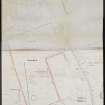
NT71SE 4 7539 1360 to 7524 1426

(NT 7524 1426 - NT 7539 1360) Earthwork (NR)

OS 6" map, (1962).

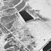
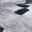
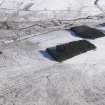
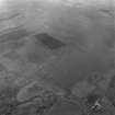
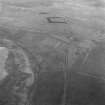
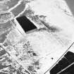
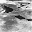
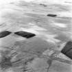
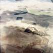
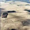
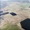
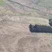
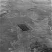
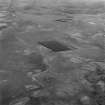
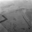
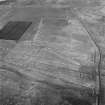
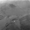
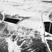
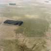
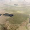
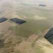
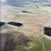
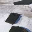
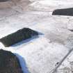
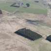
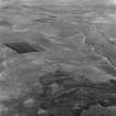
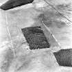
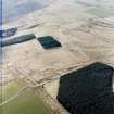
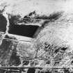
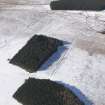
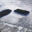
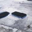
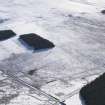
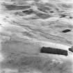
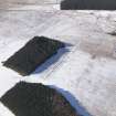
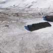
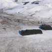
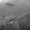
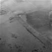
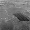
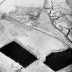
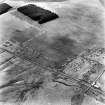
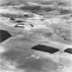
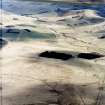
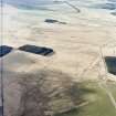
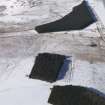
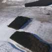
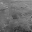
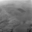
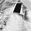
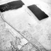
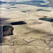
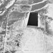
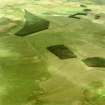
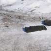
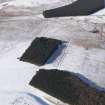
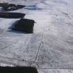
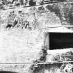
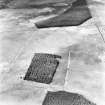
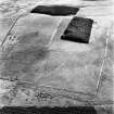
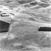
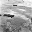
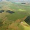
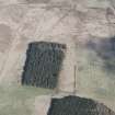
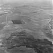
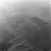
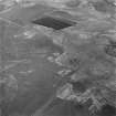
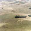
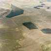
The apparent S end of this linear earthwork is now about 20 yds NE of the SW corner of the Roman camp (NT71SE 15), a cultivation having destroyed it S of this poing. The 1899 edition of the 6"map marks it as extending to just outside the corner, and there turning E to coalesce with the S rampart some 40 yds farther on; if this is correct, the earthwork may originally have rested on a small natural hollow which descends to the Kale Water here. Its best-preserved portion is near the S end, where it consists of the usual ditch and bank. From its present S end it runs nearly due N on a somewhat sinuous course, and is frequently broken by tracks; after passing the highway it shows signs of a spoil-bank on its W side. It ends, with a total length of about 780 yds, at a small wet hollow on the left bank of the burn that joins the Oxnam Water at Middlesknowes, being broken just short of the hollow by a wide traffic-gap where an old track comes down from the NE. The function of the work was no doubt to mark a boundary across Pennymuir Rig, where no natural feature exists to serve this purpose.

RCAHMS 1956, visited 1947.

This linear earthwork, consisting of a bank about 0.4m high with a ditch 0.7m deep, is as described by the RCAHMS.

Visited by OS (WDJ) 13 September 1960 and (RD) 30 May 1968

No change to field report of 30 May 1968.

Visited by OS (BS) 8 September 1976.

Activities

Aerial Photography (1970)

Oblique aerial photographs

Sbc Note

Visibility: This is an upstanding earthwork or monument.

Information from Scottish Borders Council

References

MyCanmore Image Contributions


Contribute an Image

MyCanmore Text Contributions