|
Manuscripts |
MS 731/24 |
Records of the Royal Commission on the Ancient and Historical Monuments of Scotland (RCAHMS), Edinbu |
RCAHMS archaeological field survey database: Kale Water 1999. Held as an attribute table in GIS. Please see DX001449 |
1999 |
Item Level |
|
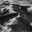 |
On-line Digital Images |
SC 1315213 |
Records of Aerofilms Ltd, aerial photographers, Bristol, England |
Hindhope Hill Hillfort and Hunthall Hill, Cheviot Hills. Oblique aerial photograph taken facing east. This image has been produced from a damaged print. |
25/11/1950 |
Item Level |
|
|
Digital Files (Non-image) |
DX 001449 |
Records of the Royal Commission on the Ancient and Historical Monuments of Scotland (RCAHMS), Edinbu |
RCAHMS Structures Database - Kale Water |
1999 |
Item Level |
|
|
Digital Files (Non-image) |
TM 000541 |
Records of the Royal Commission on the Ancient and Historical Monuments of Scotland (RCAHMS), Edinbu |
Zip file containing all survey linework data recorded during the RCAHMS Afforestable Land Survey of Kale Water 1999 |
1999 |
Item Level |
|
 |
On-line Digital Images |
SC 2454221 |
Records of the Ordnance Survey, Southampton, Hampshire, England |
Hindhope Hill, NT71SE 30, Ordnance Survey index card, Recto |
1958 |
Item Level |
|
 |
On-line Digital Images |
SC 2454222 |
Records of the Ordnance Survey, Southampton, Hampshire, England |
Hindhope Hill, NT71SE 30, Ordnance Survey index card, page number 1, Recto |
1958 |
Item Level |
|
 |
On-line Digital Images |
SC 2454223 |
Records of the Ordnance Survey, Southampton, Hampshire, England |
Hindhope Hill, NT71SE 30, Ordnance Survey index card, page number 2, Verso |
1958 |
Item Level |
|
|
Digital Files (Non-image) |
TM 002214 |
Records of the Royal Commission on the Ancient and Historical Monuments of Scotland (RCAHMS), Edinbu |
Zip file containing all survey linework data recorded during the RCAHMS Afforestable Land Survey of Kale Water 1999 - SHP and Geojson file formats with extra attribution added to the linework. |
1999 |
Item Level |
|
|
All Other |
551 166/1/1 |
Records of the Ordnance Survey, Southampton, Hampshire, England |
Archaeological site card index ('495' cards) |
1947 |
Sub-Group Level |
|


