
Hindhope Hill


Cairn (Period Unassigned)
Site Name Hindhope Hill
Classification Cairn (Period Unassigned)
Canmore ID 58085
Site Number NT71SE 30
NGR NT 77108 11310
Datum OSGB36 - NGR
Permalink http://canmore.org.uk/site/58085


- Council Scottish Borders, The
- Parish Oxnam
- Former Region Borders
- Former District Roxburgh
- Former County Roxburghshire
NT71SE 30 77108 11310.
(NT 7710 1130) Cairn (NR)
OS 6"map, (1962).
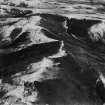
The E end of Hindhope Hill is crowned by an oval cairn which measures at the base 47' N-S by 50', the height varying from 5' to 6' above ground level. The cairn is built of small stones and is completely grassed over except at the top, where it has been opened and a number of stones have been exposed. No signs of a cist appear in the opening.
RCAHMS 1956, visited 1938.
As described above.
Visited by OS(WDJ) 13 September 1960.
No change to previous information.
Visited by OS(DWR) 25 July 1973.
A cairn generally as described by RCAHMS, but with a vague suggestion
of a ditch on its N and S sides.
Visited by OS(BS) 7 September 1976.
Sbc Note (15 April 2016)
Visibility: Standing structure or monument.
Information from Scottish Borders Council
Field Visit
NT71SE 30 77108 11310.
This cairn occupies a prominent position on the E end of the ridge that forms the summit of Hindhope Hill. It measures 13m in diameter and up to 1.8m in height, but its centre has been disturbed and the cairn material has spilled down the slope on the N.
(Kale99 32)
Visited by RCAHMS (PJD, MFTR) 1 November 1999

