 |
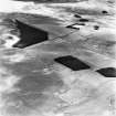
On-line Digital Images |
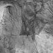
SC 1749085 |
RCAHMS Aerial Photography |
Pennymuir, oblique aerial view, taken from the SW, centred on Roman Temporary Camps and a linear earthwork. The course of 'Dere Street' is visible in the centre of the photograph. |
30/8/1995 |
Item Level |
|
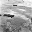 |
On-line Digital Images |
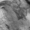
SC 1749086 |
RCAHMS Aerial Photography |
Pennymuir, oblique aerial view, taken from the WNW, centred on three Roman Temporary Camps, a linear earthwork and an area of rig. The course of 'Dere Street' is visible in the bottom half of the photograph. |
30/8/1995 |
Item Level |
|
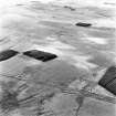 |
On-line Digital Images |
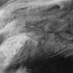
SC 1749087 |
RCAHMS Aerial Photography |
Pennymuir, oblique aerial view, taken from the NE, centred on Roman Temporary Camps, a linear earthwork and an area of rig. The course of 'Dere Street' is visible in the bottom half of the photograph. |
30/8/1995 |
Item Level |
|
|
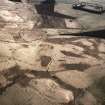
Photographs and Off-line Digital Images |
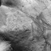
SC 1918594 |
Cambridge University Collection for Aerial Photography |
Oblique air photograph looking NW in vicinity of Pennymuir, NT 75 14, showing quarry-pits |
6/7/1949 |
Item Level |
|
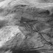 |
On-line Digital Images |
SC 1928620 |
Papers of Professor Dennis W Harding, archaeologist, Edinburgh, Scotland |
Oblique aerial view centred on Woden Law, fort, linear earthworks, cord rig and associated monuments, also shows Dere Street. |
1982 |
Item Level |
|
 |
On-line Digital Images |
SC 1928621 |
Papers of Professor Dennis W Harding, archaeologist, Edinburgh, Scotland |
Woden Law, fort, linear earthworks, cord rig and associated monuments: air photograph.
Professor D. Harding, 1982.
|
1982 |
Item Level |
|
 |
On-line Digital Images |
SC 1928622 |
Papers of Professor Dennis W Harding, archaeologist, Edinburgh, Scotland |
Woden Law, fort, linear earthworks, cord rig and associated monuments: air photograph.
Professor D. Harding, 1982. (Also shows Dere Street).
|
1982 |
Item Level |
|
 |
On-line Digital Images |
SC 1928626 |
Papers of Professor Dennis W Harding, archaeologist, Edinburgh, Scotland |
Oblique aerial view centred on Woden Law, fort, linear earthworks, cord rig and associated monuments, also shows Dere Street. |
1982 |
Item Level |
|
 |
On-line Digital Images |
SC 1928627 |
Papers of Professor Dennis W Harding, archaeologist, Edinburgh, Scotland |
Oblique aerial view centred on Woden Law, fort, linear earthworks, cord rig and associated monuments, also shows Dere Street. |
1982 |
Item Level |
|
 |
On-line Digital Images |
SC 1938984 |
John Dent |
Oblique aerial view |
1992 |
Item Level |
|
|
Digital Files (Non-image) |
TM 000541 |
Records of the Royal Commission on the Ancient and Historical Monuments of Scotland (RCAHMS), Edinbu |
Zip file containing all survey linework data recorded during the RCAHMS Afforestable Land Survey of Kale Water 1999 |
1999 |
Item Level |
|
|
All Other |
551 166/1/1 |
Records of the Ordnance Survey, Southampton, Hampshire, England |
Archaeological site card index ('495' cards) |
1947 |
Sub-Group Level |
|


