
Seacliff, Graveyard


Burial Ground (Early Medieval), Chapel (Early Medieval), Church (Period Unassigned)(Possible), Ditch (Period Unassigned), Monastic Settlement (Early Medieval)(Possible)
Site Name Seacliff, Graveyard
Classification Burial Ground (Early Medieval), Chapel (Early Medieval), Church (Period Unassigned)(Possible), Ditch (Period Unassigned), Monastic Settlement (Early Medieval)(Possible)
Alternative Name(s) Auldhame; Seacliffe
Canmore ID 57854
Site Number NT68SW 17
NGR NT 60196 84769
Datum OSGB36 - NGR
Permalink http://canmore.org.uk/site/57854

![Archaeological excavation, N edge of ditch [88], Auldhame, East Lothian](http://i.rcahms.gov.uk/canmore/l/DP00346298.jpg)
![Archaeological excavation, [87]: section across ditch S of cemetery, Auldhame, East Lothian](http://i.rcahms.gov.uk/canmore/l/DP00346310.jpg)


![Archaeological excavation, [870] and [873] without board etc., Auldhame, East Lothian](http://i.rcahms.gov.uk/canmore/l/DP00346822.jpg)


![Archaeological excavation, [092]: general with board etc., Auldhame, East Lothian](http://i.rcahms.gov.uk/canmore/l/DP00346042.jpg)


![Archaeological excavation, Cut [166]: modern posthole with board etc., Auldhame, East Lothian](http://i.rcahms.gov.uk/canmore/l/DP00346065.jpg)


![Archaeological excavation, Cut [365] for Skeleton 364, Auldhame, East Lothian](http://i.rcahms.gov.uk/canmore/l/DP00346328.jpg)


![Archaeological excavation, Grave cuts: [732], [738], and [726], Auldhame, East Lothian](http://i.rcahms.gov.uk/canmore/l/DP00346643.jpg)
![Archaeological excavation, [821]: general without, Auldhame, East Lothian](http://i.rcahms.gov.uk/canmore/l/DP00346692.jpg)


![Archaeological excavation, Cuts [882] and [879] without board etc., Auldhame, East Lothian](http://i.rcahms.gov.uk/canmore/l/DP00346774.jpg)
![Archaeological excavation, [914]: general without board etc., Auldhame, East Lothian](http://i.rcahms.gov.uk/canmore/l/DP00346814.jpg)


![Archaeological excavation, [191]: cut of grave containing Skeleton 192, Auldhame, East Lothian](http://i.rcahms.gov.uk/canmore/l/DP00346137.jpg)
![Archaeological excavation, [205]: post hole, Auldhame, East Lothian](http://i.rcahms.gov.uk/canmore/l/DP00346143.jpg)
![Archaeological excavation, [362] : general of grave cut, Auldhame, East Lothian](http://i.rcahms.gov.uk/canmore/l/DP00346260.jpg)

![Archaeological excavation, S facing section through linear feature [535], Auldhame, East Lothian](http://i.rcahms.gov.uk/canmore/l/DP00346414.jpg)
![Archaeological excavation, S facing section through linear feature [537], Auldhame, East Lothian](http://i.rcahms.gov.uk/canmore/l/DP00346416.jpg)


![Archaeological excavation, Cut [756]: General, Auldhame, East Lothian](http://i.rcahms.gov.uk/canmore/l/DP00346601.jpg)


![Archaeological excavation, [815]: general without board etc., Auldhame, East Lothian](http://i.rcahms.gov.uk/canmore/l/DP00346680.jpg)


![Archaeological excavation, [207]: cut and NW facing section of ditch (board says [203]), Auldhame, East Lothian](http://i.rcahms.gov.uk/canmore/l/DP00346140.jpg)

![Archaeological excavation, [87]: section across ditch S of cemetery, Auldhame, East Lothian](http://i.rcahms.gov.uk/canmore/l/DP00346308.jpg)


![Archaeological excavation, N edge of ditch [88], Auldhame, East Lothian](http://i.rcahms.gov.uk/canmore/s/DP00346298.jpg)
![Archaeological excavation, [87]: section across ditch S of cemetery, Auldhame, East Lothian](http://i.rcahms.gov.uk/canmore/s/DP00346310.jpg)


![Archaeological excavation, [870] and [873] without board etc., Auldhame, East Lothian](http://i.rcahms.gov.uk/canmore/s/DP00346822.jpg)


![Archaeological excavation, [092]: general with board etc., Auldhame, East Lothian](http://i.rcahms.gov.uk/canmore/s/DP00346042.jpg)


![Archaeological excavation, Cut [166]: modern posthole with board etc., Auldhame, East Lothian](http://i.rcahms.gov.uk/canmore/s/DP00346065.jpg)


![Archaeological excavation, Cut [365] for Skeleton 364, Auldhame, East Lothian](http://i.rcahms.gov.uk/canmore/s/DP00346328.jpg)


![Archaeological excavation, Grave cuts: [732], [738], and [726], Auldhame, East Lothian](http://i.rcahms.gov.uk/canmore/s/DP00346643.jpg)
![Archaeological excavation, [821]: general without, Auldhame, East Lothian](http://i.rcahms.gov.uk/canmore/s/DP00346692.jpg)


![Archaeological excavation, Cuts [882] and [879] without board etc., Auldhame, East Lothian](http://i.rcahms.gov.uk/canmore/s/DP00346774.jpg)
![Archaeological excavation, [914]: general without board etc., Auldhame, East Lothian](http://i.rcahms.gov.uk/canmore/s/DP00346814.jpg)


![Archaeological excavation, [191]: cut of grave containing Skeleton 192, Auldhame, East Lothian](http://i.rcahms.gov.uk/canmore/s/DP00346137.jpg)
![Archaeological excavation, [205]: post hole, Auldhame, East Lothian](http://i.rcahms.gov.uk/canmore/s/DP00346143.jpg)
![Archaeological excavation, [362] : general of grave cut, Auldhame, East Lothian](http://i.rcahms.gov.uk/canmore/s/DP00346260.jpg)

![Archaeological excavation, S facing section through linear feature [535], Auldhame, East Lothian](http://i.rcahms.gov.uk/canmore/s/DP00346414.jpg)
![Archaeological excavation, S facing section through linear feature [537], Auldhame, East Lothian](http://i.rcahms.gov.uk/canmore/s/DP00346416.jpg)


![Archaeological excavation, Cut [756]: General, Auldhame, East Lothian](http://i.rcahms.gov.uk/canmore/s/DP00346601.jpg)


![Archaeological excavation, [815]: general without board etc., Auldhame, East Lothian](http://i.rcahms.gov.uk/canmore/s/DP00346680.jpg)


![Archaeological excavation, [207]: cut and NW facing section of ditch (board says [203]), Auldhame, East Lothian](http://i.rcahms.gov.uk/canmore/s/DP00346140.jpg)

![Archaeological excavation, [87]: section across ditch S of cemetery, Auldhame, East Lothian](http://i.rcahms.gov.uk/canmore/s/DP00346308.jpg)


First 100 images shown. See the Collections panel (below) for a link to all digital images.
- Council East Lothian
- Parish Whitekirk And Tyninghame
- Former Region Lothian
- Former District East Lothian
- Former County East Lothian
Auldhame 1, East Lothian, cross-incised stone
Measurements: H 0.38m, W 0.38m, D 0.09m
Stone type: sandstone
Place of discovery: NT 6019 8476
Present location:
Evidence for discovery: found during excavations of a monastic site in 2005.
Present condition: good.
Description
This square block is incised with a simple linear cross with a curving shaft.
Date: seventh century or later.
References: Crone & Hindmarch 2016, SF 270.
Compiled by A Ritchie 2016
Auldhame 2, East Lothian, cross-incised stone
Measurements: H 0.33m, W 0.56m
Stone type: sandstone
Place of discovery: NT 6019 8476
Present location: in situ
Evidence for discovery: found during excavations of a monastic site in 2005.
Present condition: good.
Description
An irregular block of stone, this is incised with a simple linear cross, the right arm of which is disproportionately long.
Date: seventh century or later.
References: Crone & Hindmarch 2016, SF 270 [953].
Compiled by A Ritchie 2016
Auldhame 3, East Lothian, cross-base
Measurements: 0.69m square, H 0.30m
Stone type: sandstone
Place of discovery: NT 6019 8476
Present location:
Evidence for discovery: found on the perimeter of the promontory on which the monastic site is situated in 2005.
Present condition: good.
Description
This is a solid cross-base with a rectangular socket sunk into its upper face. The socket measures 0.23m by 0.11m and is 0.10m deep.
Date: early medieval.
References: Crone & Hindmarch 2016, SF 1280.
Compiled by A Ritchie 2016
Auldhame 4, East Lothian, cross-base
Measurements: L 0.59m, W 0.42m
Stone type: sandstone
Place of discovery: NT 6019 8476
Present location: in situ.
Evidence for discovery: found during excavations of a monastic site in 2005, re-used in the wall of later building 3.
Present condition: good
Description
This solid cross-base is carved with a rectangular socket, 0.20m by 0.07m.
Date: early medieval.
References: Crone & Hindmarch 2016, 17, SF 1287.
Compiled by A Ritchie 2016
NT68SW 17 6024 8466.
(NT 6024 8466) Grave Yard (NAT) (site of)
OS 6" map (1969)
There was formerly a graveyard at this spot. It has been disused for many years and the site is now planted with wood.
Name Book 1853
A church still existed at Auldhame in 1637. Burials are recorded there on April 11, 1619 and October 12, 1637.
P H Waddell 1893
Aldham (Auldhame) was formerly a separate parish, noted by Simeon of Durham in 854 as belonging to the bishopric of Lindisfarne. It was annexed to Whitekirk parish in the 17th century. The original church, if it were founded by St Baldred (cf NT68SW 1) may date from the 5th century (St Baldred: obit 607). The ruins of the ancient church, on the sea-cliff were apparent in 1770 but were soon after removed.
G Chalmers 1810
The graveyard was excavated in 1950, prior to the erection of an Admiralty Radar Station on the site; human remains and evidence of Christian burials were found. The excavation was carried out under the supervision of John Hamilton, Asst Inspector of Ancient Monuments, MoW, Edinburgh.
Information from J S Richardson, 7a Tantallon Terrace, N Berwick, 29 June 1952.
There is nothing to be seen of the graveyard, N of Auldhame (NT68SW 1); from the position of the symbol on OS plan part of the graveyard must have collapsed down the cliff face. This symbol does not agree with Richardson as the Radar Station (now demolished) mentioned by Dr Richardson was situated at NT 6021 8476. However, Mr J Dale Snr, of Auldhame, states that many human bones were found when constructing a roadway in to the radar station and that this roadway ran along the W side of the field wall to the W of Auldhame.
It is therefore probable that burials took place over a fairly extensive area between the ruins of Auldhume and the edge of the cliffs N of the ruins.
Visited by OS (WDJ) 13 November 1962
This site was excavated in 1950, no visible trace remains. However the burial ground may have been quite extensive and not all been destroyed by the construction of the Admiralty Radar Station.
Site recorded by GUARD during the Coastal Assessment Survey for Historic Scotland, 'The Firth of Forth from Dunbar to the Coast of Fife' 26th February 1996.
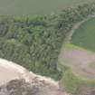
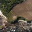
Aerial Photographic Transcription (1 May 1991 - 3 May 1991)
An aerial transcription was produced from oblique aerial photographs. Information from Historic Environment Scotland (BM) 31 March 2017.
Excavation (February 2005 - July 2005)
NT 6016 8476 An archaeological excavation and survey were undertaken between February and July 2005 after the discovery of human remains following ploughing. Following collection of these remains, test pitting and surface stripping of the affected area, the remains of an estimated 200 graves were identified. Due to the possibility of further damage to the graves it was decided that remains at risk from further damage should be rescued. During this process it became apparent that there were more graves than originally noted, resulting in 260 individual skeletons being recovered with at least a further 66 identified skeletons deemed safe and left in situ. Very little dating evidence was recovered from the graves, but possible dates may be attributed to the 9th or 10th centuries and later.
Excavation also revealed the remains of a stone building likely to be a small church or chapel showing three phases of construction. No physical dating evidence was found but comparisons with other such structures may suggest a date as early as the 9th century.
A large ditch running NW-SE across the southern edge of the site was partly excavated, but again no dating evidence was recovered. Limited examination showed that this ditch had been altered during its lifetime. It is possible that the ditch had its origins within later prehistory when it may have formed part of a promontory fort, and was altered when the site changed to ecclesiastical use.
A number of smaller features, such as pits and ditches, were located around the peripheries of the site and were seen to extend beyond the site boundaries. A limited amount of pottery was recovered from these features.
Archive to be deposited in NMRS.
Sponsor: HS
E Hindmarch 2005.
Field Visit (18 January 2008 - 22 January 2008)
NT 6016 8473 Under the terms of the Historic Scotland human remains call-off contract an evaluation was undertaken 18–22 January 2008 to determine the extent of damage to known archaeology. A large number of human bones were recovered from the surface of a damaged area and it was noted that protective Terram Geotextile matting which had been laid on the surface of the archaeological site at the end of the previous excavation in 2005 had also been brought to the surface. In addition areas of what where once buried
archaeological deposits were present on the surface including a large amount of stone from a buried chapel. It is clear that significant damage has occurred to the underlying site and chapel.
Archive: RCAHMS
Funder: Historic Scotland
Erlend Hindmarch (AOC Archaeology Group), 2008
External Reference (5 October 2011)
Scheduled as 'Auldhame, monastic settlement 310m NE of North Lodge [comprising] the remains of a chapel and burial ground set on a promontory and protected on the landward side by a broad ditch. The earliest chapel was probably a timber structure associated with graves dug between around AD 650 and 780. It is represented by the narrow foundation trench of one of the side walls. The chapel was replaced by a structure wirh clay-bonded stone foundations, built perhaps between AD 750 and 850. In addition, there is evidence for domestic structures that were probably used between AD 650 and 950, suggesting that the chapel may have been the focus for a monastic setllement. The site continued to be used intermittently as a burial ground until about 1700, during which time the chapel was also adapted and rebuilt. The remains exist as buried archaeological features preserved below ground. They were revealed by archaeological excavation in in 2005, which aimed to excavate the most vulnerable graves but to leave deeper graves and the building foundations preserved beneath reinstated topsoil. The site lies about 4km east of North Berwick and 700m ESE of Tantallon Castle, and occupies a cliff-top location overlooking the Firth of Forth and the Bass Rock.'
Information from Historic Scotland, scheduling document dated 5 October 2011.
Note (3 April 2017)
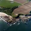
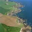
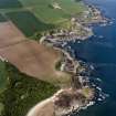
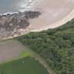
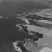
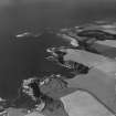
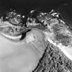
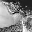
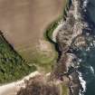
Aerial photography in 1989 identified a ditch cutting off the landward approach to a promontory on the coastal cliffs above Seacliff Harbour, a rocky inlet adjacent to a low stack known as The Gegan, upon which structural remains associated with a midden containing bone needles and pins, a dress-fastener and a decorated comb, together with a Roman gaming piece and a sherd of amphora dating from the 1st or 2nd century AD, were found in the late 19th century (Laidlaw 1870). Girt with cliffs some 20m in height on the NW, NE and SE, the broad ditch barred the approach to the promontory from the SW, enclosing an area measuring about 90m from NW to SE by 60m transversely (0.4ha). Subsequent fieldwork for a coastal survey in 1996 by GUARD on behalf of Historic Scotland observed what was probably the W end of the ditch, about 2m deep, on the cliff-edge, but subsequently ploughing exposed an extensive long cist cemetery which was partly excavated in 2005 and 2008. Carried out by AOC Archaeology Ltd on behalf of Historic Scotland to mitigate damage rather than fully excavate the site, and due to be published shortly, the final report interprets the ditch as part of the vallum of an Anglo-Saxon monastery, in which a timber chapel associated with graves dating from AD 650-780, was replaced about AD 750-850 by a stone founded structure. Evidence of domestic structures dating AD 650-950 were also recovered and the burial-ground remained in use until about 1700. While there is no reason to contest the detail of these conclusions, the incomplete nature of the excavations leaves open the possibility that the monastery had adopted an existing secular cliff-top enclosure, such as seems to have existed at Dunbar (Atlas No.3911).
Information from An Atlas of Hillforts of Great Britain and Ireland – 03 April 2017. Atlas of Hillforts - SC3921

