
Pricing Change
New pricing for orders of material from this site will come into place shortly. Charges for supply of digital images, digitisation on demand, prints and licensing will be altered.
The Chesters, Spott


Fort (Prehistoric)
Site Name The Chesters, Spott
Classification Fort (Prehistoric)
Canmore ID 57792
Site Number NT67SE 2
NGR NT 65991 73933
Datum OSGB36 - NGR
Permalink http://canmore.org.uk/site/57792


- Council East Lothian
- Parish Spott (East Lothian)
- Former Region Lothian
- Former District East Lothian
- Former County East Lothian
NT67SE 2 NT 65991 73933
(NT 6600 7392) The Chesters (NAT) Fort (NR)
OS 1:10000 map (1981)
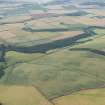
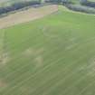
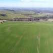
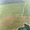
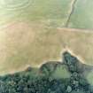
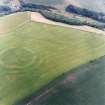
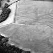
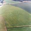
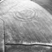
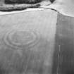
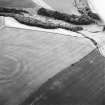
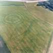
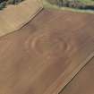
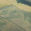
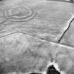
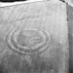
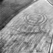
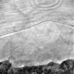
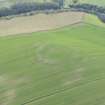
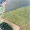
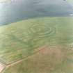
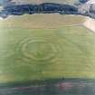
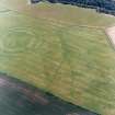
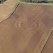
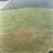
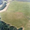
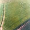
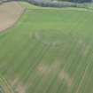
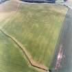
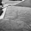
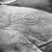
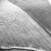
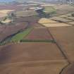
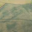
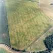
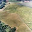
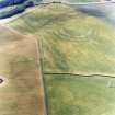
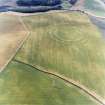
Fort, The Chesters: A large example of a circular bivallate fort, ploughed down and robbed of any stonework which may have existed, but still impressive. It measures about 350ft in diameter within two massive ramparts with external ditches. The inner rampart is now spread to a width of as much as 60ft but is still 7ft high, while the outer is 45ft wide and 5ft high. The original entrance is in the ESE, and another in the W may also be authentic.
R W Feachem 1963; RCAHMS 1924, visited 1913
This fort is generally as described by Feachem. The outer ditch has to all intents and purposes been ploughed out, while the massive inner rampart has been reduced to a stony scarp except in the SE sector. No definite entrance could be located, the most likely place for it being in the NE sector.
Resurveyed at 1:2500.
Visited by OS (WDJ) 31 March 1966
Additional aerial photographs taken in 1980 by RCAHMS and also visible on vertical air photographs, (OS 73/123/75-6, flown 1973).
Inmformation from RCAHMS
Field Visit (25 June 1913)
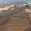
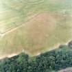
This fort, known as ‘The Chesters’, is situated at an elevation of 600 feet above sea-level, on the summit of a hill on Spott Farm. To the west the hill slopes away suddenly, but round the other sides the ground is undulating, and the whole area has long been under regular cultivation. The fort, which is circular with an internal diameter of some 352 feet, is defended by two concentric earthen ramparts 80 feet apart from crest to crest. Both the ramparts have been considerably widened by agricultural operations, and, towards the south-east, the inner rampart is now some 60 feet broad, rising 4 ½ feet on the inside and 7 ½ feet on the outside, while the outer rampart is 45 feet broad, 3 feet high on the inside and 4 ½ feet high on the outside. Between the ramparts there has been an excavated ditch more than 30 feet broad, the- bottom of which is now only 1 foot below the natural level of the ground. On the northwestern arc, where there is a steep slope, the top of the inner rampart is 20 feet higher than the outer, which has been reduced to a mere scarp by the plough. There are three broad entrances, some 24 feet wide, through the inner rampart; the first, to the east-south-east, shows a gap in the outer rampart, while the intermediate ditch at this part has not been excavated and so provides a roadway; the second, to the west, shows evidence of having a corresponding gap in the outer rampart; but there is no opening in the outer defence opposite the gap on the north-west of the inner line.
RCAHMS 1924, visited 25 June 1913.
Field Visit (5 October 1954)
Fort, The Chesters.
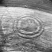
This has been one of the largest examples of the class of round forts exemplified by Kidlaw, and even in its ploughed down state it would be worth planning when the ground is in pasture or stubble. The National Survey air photographs give an excellent view of this fort, and suggest the presence of a second ditch which is not mentioned in the Inventory account.
Visited by RCAHMS (KAS) 5 October 1954.
Note (2 January 2016 - 18 May 2016)
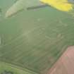
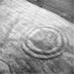
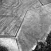
This fort, which is situated on the NW shoulder of the rounded hill above Spott Mill, is heavily ploughed down, but the massive ramparts are still plainly visible, forming broad undulations in the surface of the field, and the ditches have produced strong cropmarks in numerous years of aerial reconnaissance. Roughly circular on plan, it measures 110m from NE to SW by 105m transversely (0.89ha) within two ramparts with external ditches. The gap between the inner ditch and the traces of an internal quarry scoop indicate that the that the inner rampart was in the order of 10m thick, while the inner and outer ditches are 10m and 7m broad respectively. Taken together the defences would have formed an impressive belt in excess of 40m deep, pierced by entrances on the NE, SE, WSW and NNW respectively. Of the latter, that on the NE is a simple gap, as may have been the SE entrance too, except that a tongue of ditch projecting from the S terminal of the outer ditch, which in itself is possibly evidence of a recut phase, closes down the outer gap to create an oblique approach exposing the visitor's right side. The entrance ways of the other two entrances are also angled to expose the visitors right side, but the gaps in the outer ditch have been elaborated in slightly different ways, on the NNW by doglegging the E terminal outwards in front of the inner gap, and on the WSW by turning the S terminal inwards, inside the line of the N terminal, thus creating an overlap. There are several maculae visible on the aerial photographs within the interior, but none resolves into a clear structure. More importantly, the presence of the internal quarry scoop and the massive broad spread of the inner rampart has almost certainly created relatively deep deposits of sediment, particularly in the S half of the interior, that are likely to preserve stratified evidence of occupation.
Information from An Atlas of Hillforts of Great Britain and Ireland – 18 May 2016. Atlas of Hillforts SC3913

