
Kirklandhill


Standing Stone (Prehistoric)
Site Name Kirklandhill
Classification Standing Stone (Prehistoric)
Canmore ID 57750
Site Number NT67NW 4
NGR NT 6171 7761
Datum OSGB36 - NGR
Permalink http://canmore.org.uk/site/57750


- Council East Lothian
- Parish Whitekirk And Tyninghame
- Former Region Lothian
- Former District East Lothian
- Former County East Lothian
NT67NW 4 6171 7761.
(NT 6171 7761) Standing Stone (NR)
OS 6" map (1971)
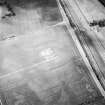
Standing Stone, Kirklandhill: This standing stone is situated in a cultivated field about 300m SW of Kirklandhill steading. It is 3.36m high and approximately square in section. Its sides are about 0.5m long at ground level.
RCAHMS 1924, visited 1913; E W MacKie 1975
This standing stone is as described.
Visited by OS (EGC) 5 November 1962.
Field Visit (24 June 1913)
206. Standing Stone, Kirklandhill.
In a cultivated field about 300 yards south-west of Kirklandhill steading is a tall stone pillar, 11 feet high and 6 feet 9 inches in girth at the base, which is almost rhomboidal on plan, with sides varying from 20 inches to 22 inches in breadth. It has a slight slant to the south.
RCAHMS 1924, visited 24 June 1913
OS Map ref: vi. S.W.
Field Visit (5 November 1962)
This standing stone is as described.
Visited by OS (EGC) 5 November 1962.

