
Knowes


Settlement (Iron Age)
Site Name Knowes
Classification Settlement (Iron Age)
Canmore ID 57720
Site Number NT67NW 19
NGR NT 61445 77593
NGR Description Centre
Datum OSGB36 - NGR
Permalink http://canmore.org.uk/site/57720


- Council East Lothian
- Parish Whitekirk And Tyninghame
- Former Region Lothian
- Former District East Lothian
- Former County East Lothian
NT67NW 19 61452 77579
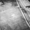
The cropmark of a settlement has been revealed by oblique aerial photography 450m ESE of Knowes farmsteading. It is roughly rectangular in shape and measures about 50m NW-SE by 40m transversely within a broad ditch with a possible entrance on the NE side. This cropmark was previously interpreted as an enclosure but indeterminate cropmarks within the interior may represent internal structures.
Information from RCAHMS (KJ) 21 September 1999.
Aerial Photographic Interpretation (21 September 1999)
The cropmark of a settlement has been revealed by oblique aerial photography 450m ESE of Knowes farmsteading. It is roughly rectangular in shape and measures about 50m NW-SE by 40m transversely within a broad ditch with a possible entrance on the NE side. This cropmark was previously interpreted as an enclosure but indeterminate cropmarks within the interior may represent internal structures.
Information from RCAHMS (KJ) 21 September 1999.
Magnetometry (August 2000 - January 2002)
Geomagnetic surveys have been carried out over a sample of 30 cropmark sites in the vicinity of Traprain Law, comprising Phase 1 of the Traprain Law Environs Project.
In the majority of cases (23 out of 30), the surveys have confirmed the presence on the ground of the enclosures shown on aerial photographs, often with very clear results. In a number of cases, the surveys have produced evidence of probable internal and/or external features which were not immediately visible on air photographs, while in other cases, the presence of these additional features has been confirmed. Several of the sites investigated appear to represent more than one phase of archaeological activity.
In the 7 cases where cropmark sites have not been readily identified, this appears to be due to a number of factors. In only one instance does the underlying igneous geology appear to be the main factor; while in several cases, anomalies not immediately relatable to the previous cropmarks were detected and might well prove be of archaeological significance.
The work reported here brings to a conclusion Phase 1 of the Traprain Law Environs Project.
Archive to be deposited in the NMRS.
Sponsors: Historic Scotland, University of Durham, and Dickinson College, Pennsylvania.
Duncan Hale and Colin Haselgrove.
Project (2000 - 2004)
A project investigating the nature and development of later prehistoric and Roman Iron Age settlement in a 15 by 10 km block of landscape around the major fortified hilltop site at Traprain Law in East Lothian.
Archaeological Evaluation (October 2002)
NT 6140 7755: The evaluation was carried out to determine the suitability and potential of the site for larger scale excavation at a later date as part of the Traprain Law Environs Project as well as for cultural resource management purposes.
The site has been shown to contain deeply buried and well-preserved deposits associated with the enclosure. The plant macrofossil evidence has excellent potential for reconstructing environment, economy and for dating purposes. The site has a high research potential and would be suitable for larger scale excavation.
Archive to be deposited in the NMRS.
Sponsors: Historic Scotland and University of Durham.
Andy Platell and Duncan Hale.
Excavation (2003)
The Traprain Law Environs Project is investigating the settlement and economy of the landscape around Traprain Law during the 1st millennia BC and AD (see DES 2003, 60-61). Since 2000, geophysical surveys have been conducted on 30 cropmark sites, which have been followed up by a series of evaluation trenches and open area excavations.
NT 614 776 Knowes Farm. Rectilinear single-ditched enclosure, initially identified by aerial photography. A geophysical survey confirmed the presence of the enclosure and noted additional anomalies likely to be archaeological in origin. These included a large trilobate anomaly close to the enclosure: an excavation across this in 2003 determined that it comprised three intercutting pits, possibly excavated for sand extraction. Several sherds of Iron Age tradition pottery were recovered from the fills.
The main excavation was positioned to sample c 40% of the enclosure interior, the defensive circuit to the W side, and the entrance through the defences to the E. The area was stripped
of topsoil and modern overburden by machine and subsequently hand-cleaned. Three distinct main phases of activity were identified.
Phase 1: Rectilinear enclosure, comprising a single ditch, with an entrance on the E side. The form of the ditch varied slightly around its circuit, and was recut at least twice. Some smaller features within the enclosure may belong to this phase, although the majority may have been removed during Phase 2.
Phase 2: A scooped settlement was constructed within the enclosure circuit. This comprised a series of interconnecting scoops forming a depression positioned centrally within the enclosure circuit. This depression was visible as a large sub-circular anomaly on the geophysical plot and covered the majority of the excavation area. The individual scoops comprised a series of circular or hexagonal structures and rooms, defined by stone-paved floors. A clay oven had been constructed in one of these. The rooms were connected with cobbled surfaces and passageways. Foundations for timber structures, pre-dating some of the stone-paved structures, were also identified, indicating more than one main phase of activity. Only a small proportion of the interior was excavated, and the overall pattern of the structures was not revealed.
The entrance to the enclosure was re-aligned on two occasions, resulting in changes to the enclosure circuit and to the internal arrangement of the structures within the scoops, and the passageway leading down into them. The enclosure circuit appeared to have been respected in some form throughout the use of the settlement. The S ditch terminal of the entrance had been revetted with a cobble wall, backfilled and covered with a cobbled surface, in the centre of which a stone cist had been constructed and used for cremation burials. The N ditch terminal had been lined with clay, for the retention of water. Next to this, a stone path had been built over the ditch, which dipped down in the centre of the ditch, probably to access the water.
Phase 3: Following the abandonment of the site, a substantial body of hill wash and silt filled in the scoops. The remains of stone and wooden structures in the scoops were covered by up to 1m of this material, resulting in an exceptionally good level of preservation.
The finds assemblage from the site is exceptional when compared with other sites investigated during the project. It includes cremated bone, small quantities of animal bone, several quernstones (mostly broken), sections of four Roman glass bangles, Iron Age tradition and some Roman pottery, and a selection of stone tools, indicating occupation during the Roman and possibly pre-Roman Iron Age.
Archive to be deposited in the NMRS
Sponsors: HS, Society of Antiquaries of Scotland, British Academy.
P Carne, D Hale and C Haselgrove 2004
Note (10 June 2023)
The location, classification and period of this site have been reviewed.

