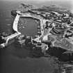
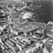
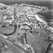
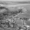
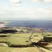
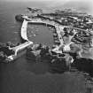
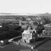
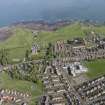
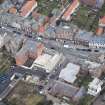
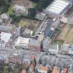
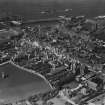
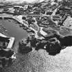
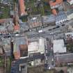
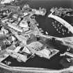
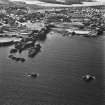
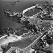
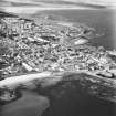
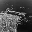
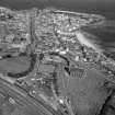
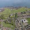
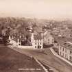
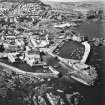
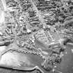
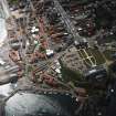
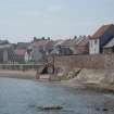
Accessibility

Font Size

100% 150% 200%

Background Colour

Default Contrast
Close Reset

Dunbar, General

Burgh (Medieval), Town (Post Medieval)

Site Name Dunbar, General

Classification Burgh (Medieval), Town (Post Medieval)

Canmore ID 57705

Site Number NT67NE 96

NGR NT 67915 78922

NGR Description Centred on NT 67915 78922

Datum OSGB36 - NGR

Permalink http://canmore.org.uk/site/57705

Ordnance Survey licence number AC0000807262. All rights reserved.
Canmore Disclaimer. © Bluesky International Limited 2025. Public Sector Viewing Terms

Toggle Aerial | View on large map

Digital Images

Drawing showing map of Dunbar and the coast of East Lothian, map of Dunbar and Belhaven about 1755 after Roy and reconstruction plan of upper floor of the Custom House, Dunbar.
Drawing showing map of Dunbar and the coast of East Lothian, map of Dunbar and Belhaven about 1755 after Roy and reconstruction plan of upper floor of the Custom House, Dunbar.Oblique aerial view.Oblique aerial view.Aerial view including church and harbour.Oblique aerial view.Oblique aerial view centred on the harbour with the remains of the battery adjacent, taken from the ESE.Oblique aerial view centred on the harbour with the remains of the battery adjacent, taken from the SW.General view of Hi Spy at full stretch.Oblique aerial view.Dunbar, House for S W Brown Esq.
Presentation drawing showing plan and elevations.General oblique aerial view with the town in the distance, taken from the SW.Oblique aerial view of the former New Inn barracks, looking E.Oblique aerial view.Oblique aerial view.Oblique aerial view centred on the harbour with the remains of the battery adjacent, taken from the S.Oblique aerial view centred on the harbour with the remains of the battery adjacent, taken from the SSE.Oblique aerial view centred on the harbour with the remains of the battery adjacent, taken from the ESE.Oblique aerial view centred on Dunbar harbour, taken from the WSW.Copy of postcard showing general view.Oblique aerial view, taken from the NE, looking SW from the sea and across the town of Dunbar (NT67NE 96), with Traprain Law fort (NT57SE 1) in the distance.Oblique aerial view of Dunbar taken from the SE.  Also visible is the Bass Rock and the coast of Fife.General oblique aerial view of the town, taken from the SSE.Dunbar, oblique aerial view.General oblique aerial view of Dunbar, Winterfield Golf Club, looking NE.Oblique aerial view of Dunbar taken from the SE.  Also visible is the Bass Rock and the coast of Fife.Oblique aerial view.Oblique aerial view centred on the harbour with the remains of the battery adjacent, taken from the ENE.Oblique aerial view centred on the harbour with the remains of the battery adjacent, taken from the W.Oblique aerial view of the burgh and town with the harbour adjacent, taken from the SSE.Oblique aerial view centred on the harbour with the remains of the battery adjacent, taken from the NNE.Oblique aerial view of Dunbar taken from the SE.  Also visible is the Bass Rock and the coast of Fife.General oblique aerial view of the country house and policies with the town beyond, taken from the SSE.General oblique aerial view of Dunbar, Winterfield Golf Club, looking NE.General view of Dunbar showing the town and harbour and the Railway Hotel.
Titled: 'Dunbar from the Church Tower. 2381. G.WW.'Oblique aerial view.Oblique aerial view centred on the harbour with the remains of the battery adjacent, taken from the WSW.Oblique aerial view centred on the harbour with the remains of the battery adjacent, taken from the SW.Oblique aerial view centred on the harbour with the remains of the battery adjacent, taken from the SSW.Oblique aerial view centred on Dunbar harbour, taken from the SW.Scanned copy of historic photograph.
General view from church tower from SE.General oblique aerial view of Belhaven, Dunbar and Winterfield Golf Club, looking N.Oblique aerial view of the former New Inn barracks, looking NE.Oblique aerial view of the former New Inn barracks, looking SE.Oblique aerial view centred on the harbour with the remains of the battery adjacent, taken from the WNW.Oblique aerial view centred on the harbour with the remains of the battery adjacent, taken from the W.Oblique aerial view centred on the harbour with the remains of the battery adjacent, taken from the WSW.Oblique aerial view centred on the harbour with the remains of the battery adjacent, taken from the SSW.Oblique aerial view centred on the harbour with the remains of the battery adjacent, taken from the ENE.Oblique aerial view centred on the harbour with the remains of the battery adjacent, taken from the NNW.Oblique aerial view centred on the harbour with the remains of the battery adjacent, taken from the WNW.Oblique aerial view centred on the barracks with fishermen's housing at Victoria Place, harbours and leisure centre adjacent, taken from the WSW.Oblique aerial view centred on Dunbar harbour, taken from the W.Oblique aerial view centred on the barracks with fishermen's housing at Victoria Place and leisure centre adjacent, taken from the NW.Oblique aerial view centred on the barracks with fishermen's housing at Victoria Place and leisure centre adjacent, taken from the WSW.General oblique aerial view of the town, taken from the ESE.Dunbar, general view, showing Victoria Harbour and High Street.  Oblique aerial photograph taken facing north.  This image has been produced from a marked print.Oblique aerial view of the former New Inn barracks, looking ESE.Oblique aerial view of Dunbar taken from the SE.  Also visible is the Bass Rock and the coast of Fife.Aerial view.Oblique aerial view.Oblique aerial view of the burgh and town with the harbour adjacent, taken from the W.Oblique aerial view centred on the barracks with fishermen's housing at Victoria Place and leisure centre adjacent, taken from the NW.Oblique aerial view centred on Dunbar harbour, taken from the S.Oblique aerial view centred on Dunbar harbour, taken from the S.General oblique aerial view of Dunbar, Winterfield Golf Club, looking E.General oblique aerial view of Dunbar, Winterfield Golf Club, looking E.General oblique aerial view of Dunbar, Winterfield Golf Club, looking NE.Oblique aerial view of the former New Inn barracks, looking ENE.Oblique aerial view.Oblique aerial view.Oblique aerial view.Oblique aerial view.Oblique aerial view centred on the harbour with the remains of the battery adjacent, taken from the SSE.Aerial view including church and harbour.General oblique aerial view of Belhaven, Dunbar and Winterfield Golf Club, looking N.General oblique aerial view of Dunbar, Winterfield Golf Club, looking NE.General view from church tower.
Titled: 'Dunbar from Church tower ?7081 G.W.W.'
PHOTOGRAPH ALBUM NO. 195: PHOTOGRAPHS BY G W WILSON & CO.Oblique aerial view taken from the NE, looking SW from the sea and across the town of Dunbar (NT67NE 96), with Traprain Law fort (NT57SE 1) in the distance.Oblique aerial view.Oblique aerial view centred on the harbour with the remains of the battery adjacent, taken from the NNW.Oblique aerial view centred on the harbour with the remains of the battery adjacent, taken from the NW.Oblique aerial view centred on fishermen's housing at Victoria Place, barracks and leisure centre with the harbour and castle adjacent, taken from the N.Oblique aerial view centred on fishermen's housing at Victoria Place, barracks and leisure centre with the harbour and castle adjacent, taken from the N.The view is taken from the NE, looking SW from the sea and across the town of Dunbar (NT67NE 96), with Traprain Law fort (NT57SE 1) in the distance.View from north-east showing Shore Street, Nos 1-7 Old Harbour, Lamer Court and Lamer Street, Dunbar.Dunbar, General, NT67NE 96, Ordnance Survey index card, Recto

Administrative Areas

  • Council East Lothian
  • Parish Dunbar
  • Former Region Lothian
  • Former District East Lothian
  • Former County East Lothian

Sir Basil Spence

Building Notes

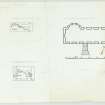
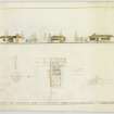
In 1946 Basil Spence and Partners designed a house for Sydney W Brown in Kirkhill Braes, Dunbar. This was possibly the first commission for the newly formed practice. The Archive holds a preliminary design for the building which was constructed circa 1948-49.

Archive Details and Summary

The Sir Basil Spence Archive holds an undated presentation drawing for this project which is likely to have been drawn in 1946 because it gives the practice address as 16 Rutland Square, from where it moved the following year.

This text was written as one of the outputs of the Sir Basil Spence Archive Project, supported by the Heritage Lottery Fund, 2005-08.

Archaeology Notes

NT67NE 96 6791 7862

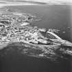
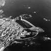
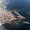
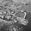
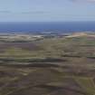
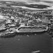
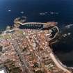
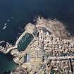
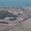
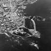
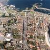
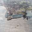
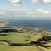
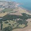
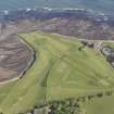
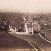
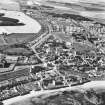
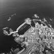
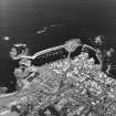
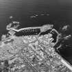
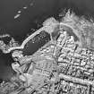
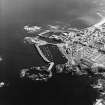
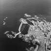
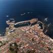
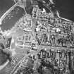
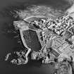
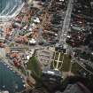
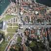
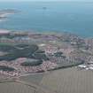
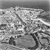
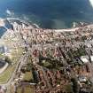
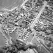
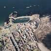
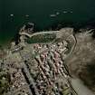
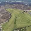
Dunbar, a 13th-century baronial burgh, became a royal burgh in 1445.

G S Pryde 1965.

Architecture Notes

NT67NE 96 67915 78922 Centre

INTERNAL REFERENCE

SNBR. Soan Museu drawings - Adam Collection.

Vol 23 Nos. 221, 203A & B & 205

EXTERNAL REFERENCE

Dunbar, Dean of Guild Drawings

1896 Dunbar Water Supply. Sections.

Plans. Dunbar, Dean of Guild Drawings. (unnumbered)

Unidentified stable plans.

Elevations and section.

Plans. Dunbar, Dean of Guild Drawings Plan no 5

1894 Unidentified shed and w.c

Plans. Dunbar, Dean of Guild Drawings Plan no 17

1895 161 High Street, Dunbar.

Proposed double cottages.

Plans. Dunbar, Dean of Guild Drawings Plan no 31

1899 Proposed w.c for Mr Purves. Common Close.

Plans. Dunbar, Dean of Guild Drawings Plan no 102

1899 Proposed alterations on attics on house belonging to James M Smith (dormers).

Plans. Dunbar, Dean of Guild Drawings Plan no 105

1901 New w.cs at unidentified house.

Plans. Dunbar, Dean of Guild Drawings Plan no 139

1902 Architect: John Farquharson, 31 Court Street, Haddington.

Unidentified additions for Messrs. Alexander D and Andrew D Melville.

Plans. Dunbar, Dean of Guild Drawings Plan no 157

Unidentified stables.

Plans. Dunbar, Dean of Guild Drawings Plan no 162

Mr J Gillies' property. Proposed new cottage.

Plans. Dunbar, Dean of Guild Drawings Plan no 200

1906 Architect: T Duncan Rhind, ARIBA., Rutland Street, Edinburgh.

Additions and alterations to house in Dunbar for Mrs Croall.

Plans. Dunbar, Dean of Guild Drawings Plan no 223

1908 Proposed improvement to shop front belonging to Miss Downie.

Plans. Dunbar, Dean of Guild Drawings Plan no 254

1911 New petrol store for Messrs Andrew Melville & Sons.

Plans. Dunbar, Dean of Guild Drawings Plan no 301

1913 Architect: Robert Orr, Haddington.

Parish Council Offices

Plans. Dunbar, Dean of Guild Drawings Plan no 322

Proposed wall (balustraded) on Mr Crook's property.

Plans: Dunbar, Dean of Guild Drawings Plan no 83

1893 Ground plan of 4 villas proposed

1895 Proposed double villas

1896 Double villas

1896 Double villas. Passed conditionally upon alteration of vent pipe

Plans: Dunbar, Dean of Guild Drawings Plan nos. 4, 27, 34 and 37 respectively

1893 Proposed additions to shop, saloon and store

Plans: Dunbar, Dean of Guild Drawings plan no 6

1903 Rockmount - proposed alterations (minor)

Plans. Dunbar, Dean of Guild Drawings. Plan no. 170

Garden and proposed hut for Mr A Tait.

Plans. Dunbar, Dean of Guild Drawings. Plan no. 211

1897 'The Cottage' proposed alterations (dormer)

Plans: Dunbar, Dean of Guild Drawings. Plan no. 52

nd Proposed alterations on yard. Plan and elevation.

Plans: Dunbar, Dean of Guild Drawings. Plan no. 8

Belford Inn: Scottish Record Office RHP 9387 1822 - plan and elevation showing alterations.

Activities

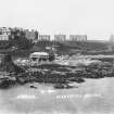
Photographic Survey (October 1965)

Photographic survey by the Scottish National Buildings Record/Ministry of Works in October 1965.

References

MyCanmore Image Contributions


Contribute an Image

MyCanmore Text Contributions