
Doon Hill


Fort (Iron Age)
Site Name Doon Hill
Classification Fort (Iron Age)
Canmore ID 57704
Site Number NT67NE 95
NGR NT 68478 75642
NGR Description Centre
Datum OSGB36 - NGR
Permalink http://canmore.org.uk/site/57704


- Council East Lothian
- Parish Spott (East Lothian)
- Former Region Lothian
- Former District East Lothian
- Former County East Lothian
NT67NE 95 NT 68475 75653
See also NT67NE 50 and NT67NE 60.
Note (2 January 2016 - 18 May 2016)
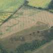
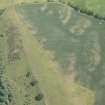
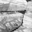
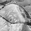
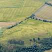
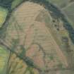
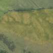
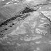
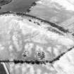
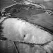
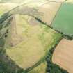
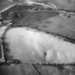
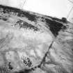
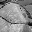
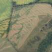
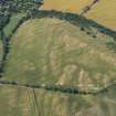
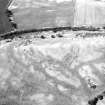
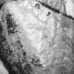
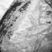
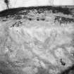
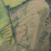
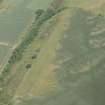
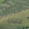
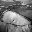
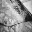
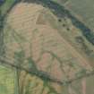
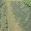
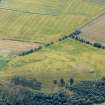
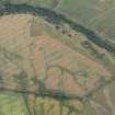
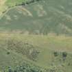
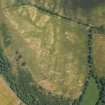
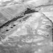
Cropmarks have revealed a timber fortification enclosing the highest part of the summit of Doon Hill, lying immediately NE of the large earthwork fort that occupies the WSW end of the hill (Atlas No.3907). Oval on plan, only the SE half of the fort has been recorded, the rest lying in an area of unresponsive rough pasture, but taking into account the contours of the topography there can be little doubt that the circuits were completed on this side. The defences comprise at least five lines of palisade trench forming a belt some 20m deep, and between the two outermost on the E and SE there are also traces of a segmented ditch between 1.5m and 2m in breadth, while a similar feature may occur immediately outside the third trench at the WSW end; other lines of palisading may be hidden by natural markings. The interior measures about 130m from ENE to WSW by at least 38m transversely to the edge of the field on the NNW, and probably as much as 55m if the palisades follow the line of the contour along this flank of the hill. Traces of a roughly concentric feature lying about 8m within the innermost line along the SE side is possibly yet another palisade trench, and apart from this the only other feature visible is a semicircular length of ditch which may be the remains of a timber round-house. No entrances have been recorded yet.
Information from An Atlas of Hillforts of Great Britain and Ireland – 18 May 2016. Atlas of Hillforts SC3910
Note (6 October 2022)
The location, classification and period of this site have been reviewed.
Note (10 June 2023)
The location, classification and period of this site have been reviewed.

