
Dunbar, Old Harbour


Harbour (17th Century)
Site Name Dunbar, Old Harbour
Classification Harbour (17th Century)
Alternative Name(s) Cromwell's Harbour; Lamerhaven
Canmore ID 57618
Site Number NT67NE 18
NGR NT 68150 79241
Datum OSGB36 - NGR
Permalink http://canmore.org.uk/site/57618


- Council East Lothian
- Parish Dunbar
- Former Region Lothian
- Former District East Lothian
- Former County East Lothian
NT67NE 18 68142 79224
For Lamer Island Battery (at NT 6811 7934) netween the Old and Victoria Harbours, see NT67NE 53.
Not to be confused with (adjacent and linked) Victoria Harbour, for which see NT67NE 147.
For adjacent warehouses, granary and housing, see NT67NE 152, NT67NE 166, NT67NE 175.
For boatbuilding yard (Messrs. Weatherhead and Blackie), see NT67NE 177.
For (adjacent) Spott's Granary (NT 68116 79243), see NT67NE 286.
For bascule bridge (NT 68056 79289) between Old and Victoria Harbours, see NT67NE 424.
(NT 6814 7922) Old Harbour
OS 6" map (NG)
EXTERNAL REFERENCE
1899 Proposed store and office to be erected for Mr T Pordage.
Plans: Dunbar, Dean of Guild Drawings plan no. 105a.
(Undated) information in NMRS.
The old harbour was 'improved' by the Burgh authorities in 1785.
Name Book 1853.
In the reign of Charles II, a harbour was formed at Dunbar by building a pier.
G Chalmers 1888.
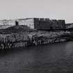
The red sandstone pier, which enclosures the old or southern harbour of Dunbar dates from the days of the Commonwealth.
I C Hannah 1913.
'Old Harbour. - The old harbour which lies to the east of its modern neighbour [NT67NE 147] is a structure dating at least from the 17th century. In December 1655 and again in 1658 it suffered severely from storms (J Miller 1859) Cromwell granted $300 towards defraying the expense of the east pier, which was begun during the time of the Protectorate and from this is known locally as 'Cromwell's Harbour'.
RCAHMS 1924
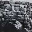
The pier enclosing the old harbour shows signs of extensive repair and reconstruction. Some old stonework is visible at the north-west end.
Visited by OS (DT) 28 August 1962.
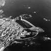
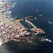
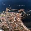
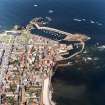
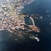
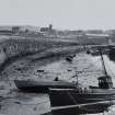
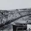
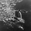
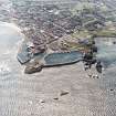
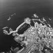
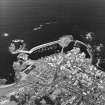
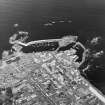
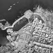
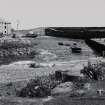
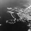
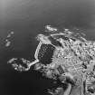
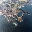
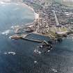
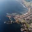
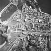
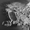
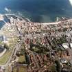
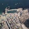
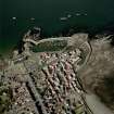
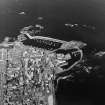
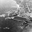
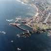
(Location cited as NT 681 792). Dunbar, East Lothian. The Old Harbour [NT67NE 18] at Dunbar had its origin in a natural tidal anchorage, partially sheltered from the N by Lamer Island [NT 6811 79348] and from the W by the Castle promontory [NT 6782 7930], but otherwise much exposed. The most important item in the existing complex of works is the East Pier [NT 68171 79310 to NT 68120 79133], a long, slightly curving structure which covers the E side of the anchorage and finishes S of the island. An access channel [NT 6812 7930], now disused, passes between the pier-head and the island. From the pier-head another pier [NT 68134 79267 to NT 68171 79310] returns SW-wards, flanking the channel, the entrance from the channel to the harbour proper lying between the end of the returned pier and a quay forming part of the W side of the harbour. From the entrance, quays are continuous along the W and S sides of the harbour, the enclosed area being about 565ft [172m] long and varying in breadth from 58ft [17.6m] in the smallish inner basin to 175ft [53.3m] in the larger northern portion. The access-channel forms an outer harbour [around NT 6812 7930], known as Broad Haven, which is flanked on the N by a causeway leading to the island. This causeway likewise separates Broad Haven from the Victoria Harbour (NT67NE 147), and entry to the Old Harbouris now obtained through Victoria Harbour and an opening in the causeway, as the seaward end of Broad Haven has been blocked [at NT 6812 7930].
The anchorage may well have been in use for a very long time, and is name, Lamerhaven, occurs in a charter of 1555, some twenty years before the building of the harbour began. This may be dated to 1574 or shortly afterwards, as the burgh was authorised in that year to raise money for the purpose, and repairs are already on record before the end of the 16th century. These repairs, and others noted between 1600 and 1613, dispose of the commonly-quoted error that the east Pier was first built by Cromwell's government, and it is clear that a breakwater in the position of the existing work would have been required from the outset for protection from the NE. The earliest breakwater was evidently in part of timber, as 'the bulwarke of the herbrie and the timber thairof' was pulled down during the Cromwellian occupation of the town. A causeway to the island is also likely to have been one of the earliest works, for the sake of protection from the W. The rest of the works were added at various dates from 1717 onwards.
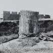
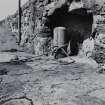
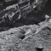
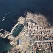
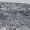
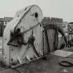
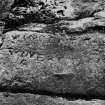
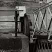
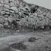
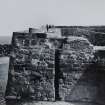
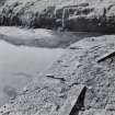
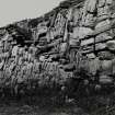
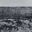
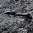
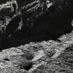
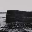
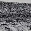
The East Pier [NT 68171 79310 to NT 68120 79133] is about 920ft [280.5m] long, including a stretch of sea-wall at its landward end, and shows many varieties of masonry including beach-boulders, large, roughly dressed blocks, and slabs set obliquely or vertically. The boulders, which tend to appear in the lowest courses, may well belong to the oldest phase of construction, while the other variations no doubt represent repairs following storm damage. One such disaster was caused by the great gale of 1655, when a grant for repairs was obtained from Cromwell's government; another collapse, which occurred in 1906, was probably responsible for the vertical and oblique work now seen in the seaward portion. The pier is up to about 16ft [4.9m] wide on top, and for much of its length has two walkways at different levels, a fact which may suggest that its height was raised at some time. The parapet is up to 5ft 6ins [1.68m] high. At one point, a flight of steps, formed of large slabs protruding from the quay-face, goes down to the bottom of the harbour. Three pawls, two of wood and one of iron, are set in recesses in the wall-face that rises from the lower walkway; they area said locally to have served for warping ships round in the N basin.
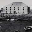
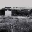
The pier-head [NT 68171 79310] was originally a roundel, but was altered after a disaster in 1879. The pier [NT 68134 79267 to NT 68171 79310] that returns from it to the harbour-entrance is 170ft [51.8m] long by 16ft 6ins [5m] at the top over a parapet 2ft 3ins [0.7m] high and thick. Its masonry differs greatly from that of the East Pier, being of squared and well-coursed blocks. At the end there stands a massive pawl made out of the butt of a tree; three other pawls have been removed. This pier was probably built in 1717, and is in any case shown on Roy's map of Scotland (1747-55). The quays on the W side and at its S end were also begun at this date, the Burgh records being full of information about the progress and cost of the work, which included the cutting back of the rock on which the quays were founded to increase the harbour's area, and also the widening of Broad Haven. The early quays extended from the S end as far as the old storehouse known as Spott's Girnel [NT67NE 286, at NT 68116 79243], itself on record in 1719. Later improvements include the Coal Wharf [location unknown], a jetty built in 1761 along the inner face of the East Pier [apparently NT 68116 79140 to NT c. 68175 79237], a dry dock, [location unknown] of 1785, which was later filled up, and the 'Holey' (hollow) Pier [location unknown], of the same date, just N of Spott's Girnel [NT67NE 286], so called because its front was originally recessed to give space in which ships could be warped round. The pawls on these quays include a heavy tree-butt at the S end, three old guns set muzzle-upwards and filled with cement, and a piece of iron pipe; there are also a number of heavy mooring-rings.
The harbour-entrance has had a rather complicated history, on account of the measures taken to equip it with booms. In summary, it seems that the question of booms was raised in 1804, that about 1827 a 'boom pier' was built, extending inwards from the end of the returned pier to opposite Spott's Girnel [NT67NE 286], and booms were established there, that this pier was ruined by a storm before 1842, only a fragment surviving in the short work with steps at the end that now projects southward from the end of the returned pier, that a position for the booms was then tried in the entrance itself and found unsatisfactory, and that in 1888 the existing concrete spur [location unstated] was built out obliquely from the end of the 'boom pier', and the booms installed in a channel thus reduced from 40ft [12.2m] to 30ft [9.1m] in length in breadth. To provide attachment for the booms on the opposite side, the face of the Holey Pier was built up flush. These booms remained in use until fairly recent years, as did the also a set in the access to Broad Haven from Victoria Harbour.
The Battery [NT67NE 53], on Lamer Island, was built after an American ship had attempted to raid the harbour in 1781. It is a red-sandstone structure with an open gun-platform, embrasures for sixteen guns, and a covered magazine and quarters for the garrison.
[Victoria Harbour is not considered in either of these articles].
A Graham 1968; A Graham 1971
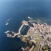
(Location cited as NT 680 793 and NT 681 792). Dunbar Harbour. The harbour is in two parts. The older section (c. 1710-30) consists of a basin formed by a curved rubble pier and a shorter straight pier. Some of the masonry is vertically set. A low wharf within the curved pier was for coal importation (1761).
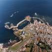
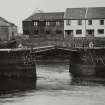
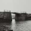
The newer part - the Victoria Harbour (1842) - is formed by a sea wall linking two rock outcrops, together with a quay along the shore parallel with the wall. This section has two entrances, one to the old harbour channel, spanned by a hand-operated, wrought-iron, two-leaf bascule bridge; the other, at the N end, is open.
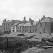
There is as 3-storey, 5-bay, harled store (Spott's Granary) on the old short pier.
J R Hume 1976.
Construction of the east pier began in the 17th century during the protectorate, and continuing into the reign of Charles II. The harbour was later "improved" by the Burgh in 1785. Generally as described in RCAHMS, the walkway and slipway are pot-holed, the original stone steps are missing in the lower portion and the timber mooring posts are decaying. The rest of the harbour is in good condition and is still in use.
Site recorded by GUARD during the Coastal Assessment Survey for Historic Scotland, 'The Firth of Forth from Dunbar to the Coast of Fife' 1996.
Construction (1575)
Construction of original harbour known as 'Lamerhaven'
Modification (1655 - 1906)
Constantly rebuilt and upgraded
Construction (1844)
'New' or 'Victoria' harbour built
Field Visit (25 May 1920)
The old harbour which lies to the east of its modern neighbour is a structure dating at least from the 17th century. In December 1655 and again in 1658 it suffered severely from storms (1). Cromwell granted £300 towards defraying the expense of the east pier, which was begun during the time of the Protectorate and from this is still known locally as ‘Cromwell's Harbour’.
RCAHMS 1924, visited 25 May 1920
(1) Miller's Dunbar, p. 241
Photographic Survey (November 1959)
Photographic survey by the Scottish National Buildings Record in November 1959.
Project (2007)
This project was undertaken to input site information listed in 'Civil engineering heritage: Scotland - Lowlands and Borders' by R Paxton and J Shipway, 2007.
Publication Account (2007)
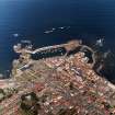
This harbour forms part of a natural tidal anchorage, formerly known as ‘Lamerhaven’, mentioned in a charter
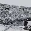
of 1555 some 20 years before the building of the harbour began. To the east of this is the old harbour enclosed by the old main breakwater or East Pier, about 920 ft long, which displays a variety of masonry constructions including beach boulders. Extensive repairs between 1655 and 1906 show further variations in the masonry. The pier is 16 ft wide at the top with walkways at different levels, perhaps indicating a subsequent heightening on one side. The pier and pier-head to the west of the East Pier is 170 ft long and is of squared, well-coursed blocks and was probably built in 1717. It is shown on Roy’s map of Scotland (1747–55) and in the foreground of the view ca.1900. In the background, across and to the west of the haven, the former entrance to which is now closed to the sea, can be seen the ‘New’ or ‘Victoria’ Harbour of about five acres extent formed in 1844 at a cost of £15 762 with a grant from the Fishery Board, whose engineer was Joseph Mitchell. Its regular coursed masonry is a good example of best practice in Scottish harbour work at the time.
R Paxton and J Shipway 2007
Reproduced from 'Civil Engineering heritage: Scotland - Lowlands and Borders' with kind permission of Thomas Telford Publishers.

