 |
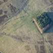
On-line Digital Images |
DP 246719 |
Historic Environment Scotland |
Oblique aerial view. |
5/1/2017 |
Item Level |
|
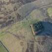 |
On-line Digital Images |
DP 246720 |
Historic Environment Scotland |
Oblique aerial view. |
5/1/2017 |
Item Level |
|
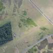 |
On-line Digital Images |
DP 278726 |
Historic Environment Scotland |
Oblique aerial view. |
26/7/2018 |
Item Level |
|
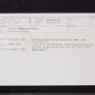 |
On-line Digital Images |
SC 2452836 |
Records of the Ordnance Survey, Southampton, Hampshire, England |
Redpath Black Dykes, NT65NE 5, Ordnance Survey index card, Recto |
c. 1958 |
Item Level |
|
 |
On-line Digital Images |
SC 2452837 |
Records of the Ordnance Survey, Southampton, Hampshire, England |
Redpath Black Dykes, NT65NE 5, Ordnance Survey index card, page number 1, Recto |
c. 1958 |
Item Level |
|
 |
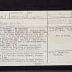
On-line Digital Images |
SC 2452838 |
Records of the Ordnance Survey, Southampton, Hampshire, England |
Redpath Black Dykes, NT65NE 5, Ordnance Survey index card, page number 2, Verso |
c. 1958 |
Item Level |
|
|
All Other |
551 166/1/1 |
Records of the Ordnance Survey, Southampton, Hampshire, England |
Archaeological site card index ('495' cards) |
1947 |
Sub-Group Level |
|


