
Redpath Black Dykes


Linear Earthwork (Period Unknown)
Site Name Redpath Black Dykes
Classification Linear Earthwork (Period Unknown)
Canmore ID 57410
Site Number NT65NE 5
NGR NT 68157 59151
NGR Description Centre
Datum OSGB36 - NGR
Permalink http://canmore.org.uk/site/57410


- Council Scottish Borders, The
- Parish Longformacus
- Former Region Borders
- Former District Berwickshire
- Former County Berwickshire
NT65NE 5 68 59.
(A. NT 6802 5924 - NT 6824 5902)
(B. NT 6929 5906 - NT 6826 5932)
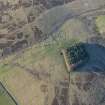
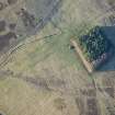
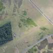
Redpath Black Dykes. Two dykes 1100yds SW of Redpath. One commences 90yds. North of Redpath road end, and runs WNW for 125yds to within 8yds of the Longformacus Road; it then bends NWW. Total length 350yds. The other lies to the NE being 130yds distant at its north-west end. It is 180yds long. The lower dyke is 32' overall; trench 4'9" deep. Mound on each side of ditch. Second dyke similar, but of lesser proportions.
J H Craw 1928.
Two earth and stone banks
"A" average overall 9.5m; with trench between, average depth 1.4m.
"B" Of similar construction, average overall 8.5m, with trench between 0.8m average depth.
Visited by OS (JFC) 16 December 1954.
"B" resurveyed. These are unusual dykes, rather like bi-vallate "covered-ways", but their purpose is uncertain.
Visited by OS (JLD) 23 December 1954.
As described above, they consist of a ditch with an up-cast mound on each side.
Extent: "A" - From NT 6802 5924 to NT 6824 5902.
"B" - From NT 6815 5935 to NT 6822 5918.
Visited by OS(WDJ) 29 October 1963.
Listed
RCAHMS 1980, visited 1979.
Field Visit (June 1911)
253. ‘Dyke’, Redpath.
Some 1100 yards south-west of Redpath a dyke or track runs for some 360 yards in a north-westerly direction. To the south it terminates at the edge of cultivated land, and to the north in ground of a boggy nature. It consists of a trench, with a mound on each side, measuring 28 feet over all where best preserved, the bottom of the trench being 4 feet 3 inches below the crest of the mounds. Parallel and some 210 yards to the east, runs a similar ‘dyke’ 195 yards in length. It is of equal width, but only about 2 ½ feet in depth.
RCAHMS 1915, visited June 1911.
OS Map: Ber., ix. SE.
Note (8 October 2019)
The location, classification and period of this site have been reviewed.
Sbc Note
Visibility: This is an upstanding earthwork or monument.
Information from Scottish Borders Council

