
Greenknowe Tower


Earthwork(S) (Period Unassigned), Tower House (16th Century)
Site Name Greenknowe Tower
Classification Earthwork(S) (Period Unassigned), Tower House (16th Century)
Canmore ID 57386
Site Number NT64SW 5
NGR NT 63956 42846
Datum OSGB36 - NGR
Permalink http://canmore.org.uk/site/57386


- Council Scottish Borders, The
- Parish Gordon
- Former Region Borders
- Former District Berwickshire
- Former County Berwickshire
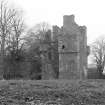
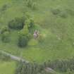
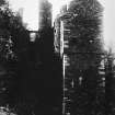
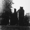
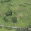
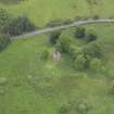
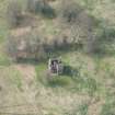
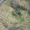
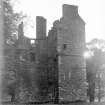
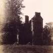
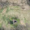
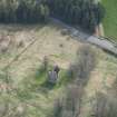
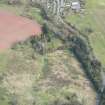
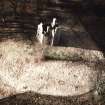
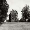
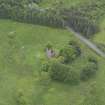
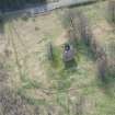
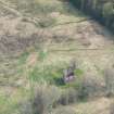
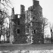
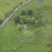
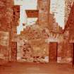
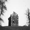
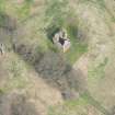
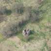
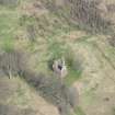
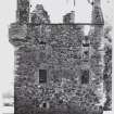
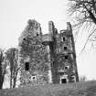
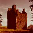
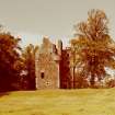
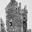
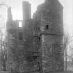
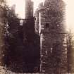
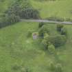
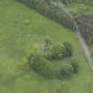
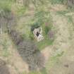
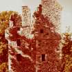
The ruins of Greenknowe Tower stand on a low knoll situated about 500m to the south-west of Gordon village. The tower was once surrounded by marshland, an important factor in its defence.
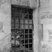
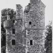
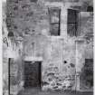
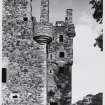
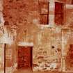
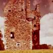
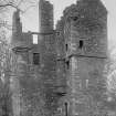
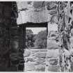
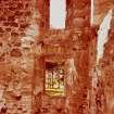
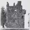
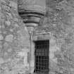
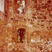
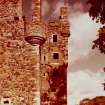
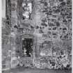
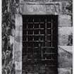
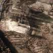
Greenknowe is L-shaped on plan and consists of a three-storeyed main block with an adjoining wing which housed the main stair from the ground-floor kitchen to the first floor hall. A single doorway gave access to the tower, placed in the re-entrant angle, that is, where the two wings meet. Behind the timber door there was a yett, a heavy wrought-iron grill, which prevented attempts to batter or burn the door down.
Greenknowe was a fortified residence, well-equipped for defence. Numerous shot-holes for guns around the tower gave it a defensive appearance and would have allowed the defenders to bring their guns to bear on attackers from any angle.
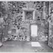
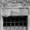
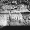
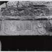
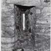
Sir James Seton of Touch built Greenknowe in 1581. This date, Seton's initials and armorial, together with those of his wife, Jane Edmonstone, are carved on the lintel of the entrance-doorway.
Text prepared by RCAHMS as part of the Accessing Scotland's Past project
NT64SW 5.00 63956 42846
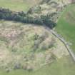
NT64SW 5.01 NT 639 428 Cultivation remains
(NT 6395 4284) Greenknowe Tower (NR) (remains of)
OS 6" map, (1968).
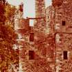
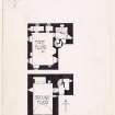
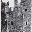
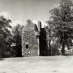
Greenknowe Tower was built by Sir James Seton in 1581 (the date is inscribed on the lintel above the entrance). It stands on a low grassy knoll, originally defended by marshy ground on all sides. (Lyal alleges that it was surrounded by a moat, remains of which can still be seen.) It was habitable up till the early 19th century and is now a well-preserved ruin on the L-plan, with a main block measuring some 24 ft by 15 ft, and a wing at the NE measuring 15 ft 6 ins by 10 ft 4 ins (see plan). The main block now stands four storeys in height, the wing a storey higher. Three of the angles are surmounted by small turrets with gun-loops, and in the re-entrant angle above the first floor rises a stair-turret.
D MacGibbon and T Ross 1889; RCAHMS 1915, visited 1912; N Tranter 1962; M Lyal 1962; A M T Maxwell-Irving 1974; RCAHMS 1980, visited 1979.
Repairs have been carried out by the D o E to preserve the remains of this tower.
Visited by OS (JD) 23 May 1955.
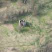
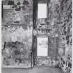
The remains of this tower are as described above. A rectangular portion of a stone wall, 0.8 m wide and 0.4 m high, enclosing a small paved area with steps leading off the N side, has been revealed 15.0 m NE of the NE corner of the tower; another portion of paving has been cleared in the re-entrant angle. The grassy knoll on which the tower stands appears to have been landscaped in places to give it a flattish top.
Visited by OS (WDJ) 18 November 1963.
Re-excavation within the courtyard of Greenknowe Tower revealed the disturbed footings of a stables to the NE of the tower. Final excavation to the N showed extensive damage to other buildings by stone-robbing in the late 19th century. Artefacts found include a hardhead of Mary, countersunk in 1572.
C J Tabraham 1979.
Greenknowe Tower which stands on a knoll to the W of Greenknowe, is a Guardianship monument, signposted and open to the public. It is in a good state of repair, and the datestone of 1988 that is carved into the garret dates the latest restoration. There appear to have been no defensive earthworks.
Visited by RCAHMS (RJCM, JRS) 30 September 1993.
Earthworks (non-defensive) and cultivation remains visible on J Dent aerial photographs.
Information from RCAHMS (KM) 25 September 1995.
Field Visit (12 April 1912)
165. Greenknowe Tower.
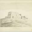
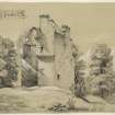
Greenknowe tower (fig. 84 [SC 1173042]) is situated on the north side of the main road leading to Earlston and distant about 1/2 mile to the west of the village of West Gordon. It stands upon a low grassy knoll which has been originally defended by marshy ground on all sides, of which ample evidence still remains. Immediately to the west of the tower there is a considerable extent of level ground which possibly marks the site of a garden, while rows of stately trees seem to indicate the line of an avenue which has approached the castle from the north.
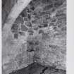
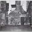
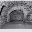
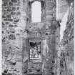
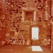
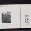
The building is L-shaped on plan (fig. 85 [DP 225415]), the larger wing measuring some 24 feet by 15 within walls averaging 4 feet in thickness, while the shorter wing is 15 feet 6 inches in width with a projection of 10 feet 4 inches eastwards. The entrance doorway, with its fine iron yett (described in the Proceedings of the Society of Antiquaries of Scotland cited below), is in the usual position at the re-entering angle, giving direct access to the stair foot, whence a doorway in the main east wall leads down three steps to the vaulted kitchen, which has an arched fireplace formed in the north wall 8 feet 6 inches wide by 5 feet deep. There is a small wall recess at the back of the west in-go and also an ambry in the main north wall. The three remaining sides of this apartment are lighted by small loophole: windows, the one in the east wall being placed so as to command the entrance. A small trap'-door has been constructed in the crown of the main vault, no doubt for the haulage of goods from the kitchen to the floor above. The great hall on the first floor is gained by means of a spacious wheel-stair with steps 4 feet 6 inches in width, whence the usual turret staircase, corbelled out over there-entering angle, has communicated with three upper floors, giving access to rooms over both the hall and staircase wings. It has been well lighted by windows on three sides, which are now built up. The hall fireplace, formed in the east wall, is decorated with ornate side pilasters, with moulded caps and bases set some 6 feet apart and having a projection of about 6 inches from the wall-face, supporting a stone lintel 9 feet in length and 1 foot 10 inches in depth over which there is a straight saving-arch. The kitchen chimney flue has been carried up the centre of the north gable, on each side of which there has been originally a small recess or closet lighted from the exterior. Within recent times one bridge of the flue has been partially destroyed in order to enlarge the west recess. Formerly the access to this closet appears to have been by a recessed doorway at the west angle, which has been subsequently built up. It is probable that the existing doorway was constructed at the same time in the position shown on the plan. It is also to be noted that the north gable has been thickened on the interior in order to facilitate the construction of the fireplaces above. The gables are all finished with crow-steps in the usual way, and there are three circular angle-turrets springing from corbels at the third floor level. The carved lintel over the entrance doorway (fig. 86 [SC 1173044]) is of considerable interest. It has a projecting hood-moulding wrought on the upper edge and sides. Carved in relief on a central raised panel is the date 1581 flanked by two shields between the letters 1.S· and I·E. (for James Seton and Jane Edmonstone his wife). The dexter shield is charged as follows, viz. : Quarterly, 1st and 4th, Three crescents within a royal tressure (for Seton); 2nd and 3rd, Three escutcheons (for Hay). The sinister shield is charged with three crescents, 2.and 1 (for Edmondstone). It is on record that the Seton family acquired the property by marriage with the heiress of Gordon of that ilk about the beginning of the 15th century, and the tower appears to have been built by James Seton of Touch in 1581, the date on the lintel over the doorway. In the 17th century it passed by purchase from the Setons of Touch to the Pringles of Stichel, and was occupied by Walter Pringle, a noted covenanter and an author.
Greenknowe is a good example of the castellated building of its period; the main walls are in a fair state of preservation, but the wall-heads and angle-turrets are much ruined. Owing to constant exposure to wet and frost, the main vault shows signs of weakness and requires immediate attention.
See Cast. and Dom. Arch., iii. p. 542 (plans and illus.); Ber. Nat. Club, 1879-81, p. 232: Antiquaries, xvi. p. 114; A History of the Family of Seton, ii. p. 978.
RCAHMS 1915, visited 12th April 1912.
OS Map: Ber, xxvii. NW.
Publication Account (1985)
'Green knowe' or 'green hill' was once surrounded by marshy ground-an important feature in its defence. Built in the late 16th century, it is a classic L-shaped tower-house consisting of a main rectangular block with a shorter wing. The entrance is found at the 're-entrant' angle, its usual position, where the two wings meet in a right-angle. It was thus easily defended or covered from the tower.
The turnpike stair just beyond the entrance leads down to the vaulted kitchen with its large arched fireplace. It also leads up to the main hall, whence the usual turret stair corbelled out from the re-entrant corner rises to the upper floors of both the main tower and the wing. Some of the all plaster survives in the hall; the fireplace is decorated with ornate side pilasters; the kitchen flue is carried up the north wall with small closets built in either side. The westward one may have been a garderobe or toilet. Along the gable-edges the crowsteps are typical, whilst three circular angle turrets spring from corbels at third-floor level.
The entrance comprises a stout timber door with a strong iron yett immediately behind- difficult to batter or burn down. Above, the lintel incorporates a finely sculptured panel dated 1581, with two sets of initials and two shields. The Seton family acquired the property by marriage in the early 15th century and the tower was apparently built by James Seton of Touch (I.S.) in 1581, with his wife Jane Edmonstone (I.E.).
Information from 'Exploring Scotland's Heritage: Lothian and Borders', (1985).
Note (19 November 2015)
The entry in the Schedule of Monuments relating to this monument was amended in 2015.
Information from Historic Environment Scotland, 19th November 2015
Sbc Note
Visibility: Upstanding building, which may not be intact.
Information from Scottish Borders Council

