Scheduled Maintenance
Please be advised that this website will undergo scheduled maintenance on the following dates: •
Tuesday 3rd December 11:00-15:00
During these times, some services may be temporarily unavailable. We apologise for any inconvenience this may cause.
Castle Hill
Fort (Prehistoric), Settlement (Prehistoric)
Site Name Castle Hill
Classification Fort (Prehistoric), Settlement (Prehistoric)
Alternative Name(s) Ale Water
Canmore ID 57086
Site Number NT62SW 1
NGR NT 62410 24910
Datum OSGB36 - NGR
Permalink http://canmore.org.uk/site/57086
- Council Scottish Borders, The
- Parish Ancrum
- Former Region Borders
- Former District Roxburgh
- Former County Roxburghshire
NT62SW 1 62410 24910.
(NT 6241 2491) Fort (NR).
OS 6" map, Roxburghshire, (1923).
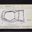
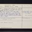
'...Castle Hill, Ancrum, with its oval citadel and two rectilinear linked courts, falls most readily into this class...' (The 'class' is composed of forts belonging to the Dark Age "nuclear type of fortification. The site is also marked on the distribution map as a Dark Age Fort.)
(RCAHMS 1956, 35, fig. 22)
Feachem includes this site in the 'smaller walled settlement' class and suggests that the main enclosure and the fragmentary external wall may have formed the original work, with the double annexe being added later, though not necessarily after a break in occupation.
(R W Feachem 1965).
As described and planned by RCAHMS.
Re-surveyed at 1/2500
Visited by OS (WDJ) 2 February 1967.
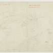
Measured Survey (24 April 1934)
Surveyed by plane-table.
Field Visit (26 July 1949)
Fort, Castle Hill.
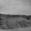
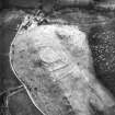
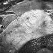
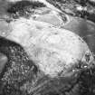
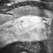
On Castle Hill, which lies in a bend of the Ale Water, a quarter of a mile NW of Ancrum village, there is a fort of uncommon type in a comparatively good state of preservation. The hill is nothing more than the bulky W. end of an otherwise narrow ridge, and its top, standing at a height of only 350ft OD, is easily accessible either from the E along the gently inclined crest of the ridge or from the N. across a shallow gully which separates it from an isolated rocky knoll: on the S and W, however, its sides rise steeply for over 100ft from the haugh of the Ale Water.
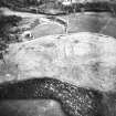
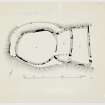
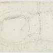
The fort (see RCAHMS 1956, fig.94) occupies the whole of the flat-topped summit of the hill and comprises three contiguous enclosures, lying roughly E and W; the westernmost enclosure (A) is oval on plan while the other two (B and C) are subrectangular. Enclosure A measures 200ft from E to W by 165ft from N to S within a boulder-faced rubble wall which, except on the E side, is from 7ft 6in to 10ft thick. Many of the foundation-stones of this wall are still in situ, including a number of massive grounders up to 4ft 6in long such as are found loose on the surface of the ridge or may be easily quarried from the outcrops on the adjacent knoll. Some of the larger slabs are laid on edge as at Buchtrig fort (RCAHMS 1956, no.307). The E wall is markedly thinner, measuring only 5ft in thickness at the S end, but this may be due to later modification. Round the margin of a terrace which breaks the hill-slope on the N and W sides of enclosure A there is an outer wall, one end of which returns sharply and originally terminated in a butt-joint against the SW corner of the inner wall, while the other end unites with the N wall of enclosure B. Only one or two facing-stones of this outer wall are visible on the N side, but on the W a line of outer foundations, similar in character to those of the main wall, is preserved for a length of 55ft : the largest stone measures 5ft 6in long, 3ft high, and 1ft 6in deep and is laid on edge. There are two entrances to enclosure A, one on the E side communicating with enclosure B, and the other at the NW corner leading directly through both the inner and outer walls : it is possible, however, that the latter entrance may be intrusive and connected with the cultivation of enclosure A which has taken place at no very distant date. At the present time the whole of the interior is thickly covered with nettles and contains no trace of structures.
Enclosures B and C measure respectively 175ft by 70ft and 180ft by 80ft within walls similar in construction to those of A, and varying in thickness from 7ft 6in to 12ft. Each has an entrance on the E in line with that of enclosure A; and the only internal feature is a rough dividing wall formed by a line of boulders 50ft long at the S end of enclosure B.
It is impossible to tell by superficial examination whether the three enclosures represent contemporary or successive works, since the junctions of their walls are concealed by the spread of the core. The uniform construction of these walls and the symmetrical arrangement of the entrances suggests that the enclosures are contemporary, and if this is so it seems likely that the fort dates to the Dark Ages. If, on the other hand, the enclosures are successive, the oval enclosure may be prehistoric while the two subrectangular enclosures might be additions made in the Roman or post-Roman period.
About 140yds E of the fort an old-field-dyke, consisting of a line of earthfast boulders, can be traced northwards from the crest of the ridge to the flanking gully.
RCAHMS 1956, visited 26 July 1949.
Measured Survey (12 September 1949)
Surveyed by plane-table.
Note (1 September 2015 - 4 August 2016)
This unusual fort is situated on a ridge that lies in a bend of the Ale Water opposite Ancrum. The fort occupies the SW tip of the summit, where the ground falls away steeply down to the river on the SW and SE, and on the NW into a shallow gully, and comprises an oval inner enclosure accompanied by two courts formed between widely-spaced outer walls on the gentle approach from the NE. The inner enclosure measures about 63m from NE to SW by 50m transversely (0.25ha) within a wall from 2.2m to 3m in thickness, with massive facing-stones visible both inside and out. An outer wall apparently springs from the inner on the SW and encircles the weaker W and NW flanks, returning to the NW side of the inner of two enclosed courts on the NE. The courts are both trapezoidal, and enclosed by similarly constructed walls, the plan suggesting that they have been successively added to the fort, though the junctions of the wall are buried in rubble. The inner measures internally a maximum of 50m from NW to SE by 21m transversely (0.09ha), and the outer 62m by 25m respectively (0.15ha). There are two entrances, one on the E, approached through the two courts, each of which has a gap in the wall adjacent to its E corner, and the second piercing both walls on the W, though in 1949 RCAHMS investigators speculated that the latter may have been to facilitate the cultivation at a relatively recent date of the otherwise featureless interior.
Information from An Atlas of Hillforts of Great Britain and Ireland – 04 August 2016. Atlas of Hillforts SC3382
Sbc Note
Visibility: This is an upstanding earthwork or monument.
Information from Scottish Borders Council


