
Pricing Change
New pricing for orders of material from this site will come into place shortly. Charges for supply of digital images, digitisation on demand, prints and licensing will be altered.
Millside Wood


Temporary Camp(S) (Roman)
Site Name Millside Wood
Classification Temporary Camp(S) (Roman)
Canmore ID 57056
Site Number NT62SE 44
NGR NT 691 222
Datum OSGB36 - NGR
Permalink http://canmore.org.uk/site/57056


- Council Scottish Borders, The
- Parish Jedburgh
- Former Region Borders
- Former District Roxburgh
- Former County Roxburghshire
NT62SE 44 691 222.
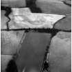
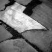
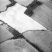
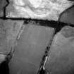
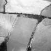
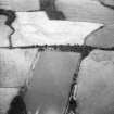
NT 691 222. Cropmarks reveal a Roman camp lying to the north of Dere Street (RR 8f). Considerable lengths of the NW and SE sides have been recorded and indicate an area about 1200ft NW-SE by 1500ft transversely.
J K St Joseph 1973.
A second Roman temporary camp has been observed, overlapping the camp noted above.
Information contained in letter from J K St Joseph to OS 12 October 1977
Publication Account (17 December 2011)
The two cropmark camps at Millside Wood lie on the north-east side of D ere Street, opposite the camps of Ulston Moor and a little way from the fort and camp at Cappuck. Camp I was first discovered in 1971 by St Joseph from the air (1973: 216) and measures at least 510m from south-west to north-east by 384m. It enclosed at least 19.4ha, and an assessment of the topography together with the morphology of the camp suggests that it may have enclosed just over 20ha (50 acres). Probable entrance gaps are recorded in the north-west, south-west and south-east sides; that on the south-east side also possesses a titulus. A second camp (II ), recorded in 1976 by Maxwell from the air (RCAHMS 1976: 84), lies wholly within camp I, but does not reuse any part of its perimeter. This small camp measures 174m from NNE to SSW by 138m and encloses almost 2.4ha (nearly 6 acres). Part of the perimeter of the ESE and NNE sides is reflected in edge of the Millside Wood plantation (also see above, section 7h). A further small camp or annexe is attached to its north-west side, but the relationship between these two cannot be determined beyond the reuse of one side. The annexe measures approximately 60m by c 40m, enclosing an additional 0.24ha (0.6 acres).
R H Jones.
Sbc Note
Visibility: This site is visible as a cropmark.
Information from Scottish Borders Council

