
Pricing Change
New pricing for orders of material from this site will come into place shortly. Charges for supply of digital images, digitisation on demand, prints and licensing will be altered.
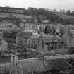
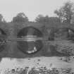
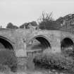
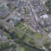
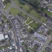
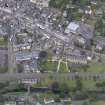
Jedburgh, Canongate, Canongate Bridge


Road Bridge (16th Century)
Site Name Jedburgh, Canongate, Canongate Bridge
Classification Road Bridge (16th Century)
Alternative Name(s) Jedburgh, Auld Brig; Jed Water
Canmore ID 57034
Site Number NT62SE 25
NGR NT 65260 20597
Datum OSGB36 - NGR
Permalink http://canmore.org.uk/site/57034


- Council Scottish Borders, The
- Parish Jedburgh
- Former Region Borders
- Former District Roxburgh
- Former County Roxburghshire
NT62SE 25 65260 20597
Canongate Bridge [NAT]
OS (GIS) AIB, April 2008.
Bridge, Jedburgh. This bridge which spans Jed Water at the foot of the Canongate, 250yds [229m] NE of the abbey (NT62SE 15.00) and immediately below a ford, is an unusually fine 16th-century structure. It consists of three segmented arches, each of which has had four chamfered ribs on its soffit; but two ribs are now missing from the easternmost arch. The piers separating the arches extend outwards as cut-waters, and support refuges at road-level. Inserted in the parapets of the two easternmost refuges are several chamfered rybats; these have obviously come from a church, probably that of the Grey Friars. The roadway varies in width from 9ft 6in [2.89m] to 9ft 10in [3.0m] and is 'bowed' or hump-backed. The approaches lie at right angles to the main structure, the E one running from N to S and the W one from S to N.
RCAHMS 1956, visited 28 July 1931.
NT 6526 2059. The bridge, at present under repair, is as described and illustrated by RCAHMS 1956.
It is for pedestrians only.
Visited by OS (EGC), 4 January 1963.
Non-Guardianship Sites Plan Collection, DC28029- DC28031, 1962.
(Undated) information in NMRS.
(Location cited as NT 653 205). Canongate Bridge, 16th century. A three-span, dressed-stone bridge, with approximately elliptical four-ribbed arches of unequal size. The trinagular cutwaters are carried up to form semi-hexagonal refuges. A particularly fine example of a 16th century bridge.
J R Hume 1976.
Photographic Survey (April 1962)
Photographic survey of buildings in Jedburgh, Roxburghshire, by the Scottish National Buildings Record in 1962.
Photographic Survey (1964)
Photographic survey of buildings in Jedburgh, Roxburghshire, by the Scottish National Buildings Record/Ministry of Work in 1964.
External Reference (12 November 2014)
Monument descheduled as it was a dual designation. It remains a listed building (Ref, 35471).
Information from Historic Scotland, 12 November 2014
Sbc Note (15 April 2016)
Visibility: Standing structure or monument.
Information from Scottish Borders Council

