
Dirleton Castle


Castle (Medieval)
Site Name Dirleton Castle
Classification Castle (Medieval)
Canmore ID 56735
Site Number NT58SW 1
NGR NT 51609 83929
Datum OSGB36 - NGR
Permalink http://canmore.org.uk/site/56735


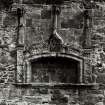
![Engraving of elaborate fireplace at Dirleton Castle.
Titled 'Canopied seat at Dirleton Castle.' [Billings 1845-52.]](http://i.rcahms.gov.uk/canmore/l/DP00097907.jpg)


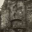


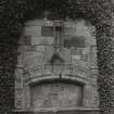


![Engraving of elaborate fireplace at Dirleton Castle.
Titled 'Canopied seat at Dirleton Castle.' [Billings 1845-52.]](http://i.rcahms.gov.uk/canmore/s/DP00097907.jpg)


First 100 images shown. See the Collections panel (below) for a link to all digital images.
- Council East Lothian
- Parish Dirleton
- Former Region Lothian
- Former District East Lothian
- Former County East Lothian
NT58SW 1 51609 83929
NT58SW 1.01 5160 8396 Piper's Hole
NT58SW 1.02 51456 83965 Tower
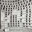
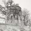
NT58SW 1.03 51620 84022 Dovecot
NT58SW 1.04 51527 83923 Garden
For Castle / Mains Gateway to NW see NT58SW 40 51645 84028.
(NT 5152 8396) Dirleton Castle (NR) (remains of)
(NT 5162 8402) Dovecot (NR)
OS 6" map, (1968).
Dirleton Castle, and its associated dovecot, are fully described, planned and illustrated in the MoW official guidebook.
J S Richardson 1950.
NMRS REFERENCE:
M.O.P.B. & W. Guardianship Monument
David Thomson. Head Gardener at Archerfield. Created a pair of flower gardens at Dirleton.
NMRS Print Room:
Wood Sketch Book II, 3 sketches
Field Visit (June 1919 - September 1924)
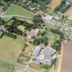
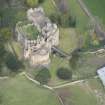
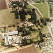
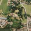
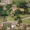
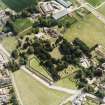
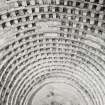
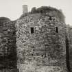
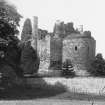
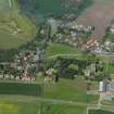
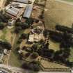
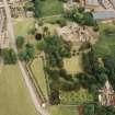
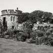
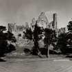
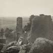
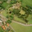
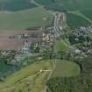
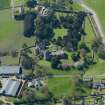
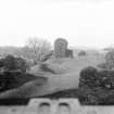
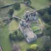
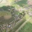
This imposing ruin is situated immediately east of the village green of Dirleton within a walled pleasaunce and is built on the crest of an outcrop of rock, which rises sheer on the north, west and south to an elevation of 100 feet above ordnance datum and within 25 feet at most above the immediate level but has a more gradual inclination on the east. The rock summit is roughly quadrilateral, measuring 135 feet from north to south by 115 feet from east to west, and has been entirely enclosed by the building of a wall of enceinte incorporated in structures on the north, south and east (fig. 55).
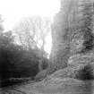
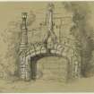
OUTWORKS. The southern face of the site, in which is set the main entrance, is strengthened by a dry ditch 45 feet wide and in places 15 feet deep cut in part through the rock (fig. 56). This was spanned by a bridge, probably of wood, supported on stone piers, which still remain in the ditch. Traces of a ditch some 30 feet wide are seen also at the north-eastern angle of the site. On the west the rock is sufficiently steep to make a further obstacle unnecessary. On the east, where the rock has an easy gradient, there is no trace of any outwork, but it should be noted that the lower 27 feet of the eastern wall contains no openings except a small entrance built up in the 15th century, if not earlier.
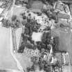
ENCLOSURE. West of the castle there is an area some 80 to go yards square, which is enclosed by an earthen mound planted with old yew trees-apparently a bowling green, as in the similar case at Dunnottar Castle.
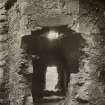
GATEWAY. Immediately east of the dovecot is a contemporary gateway with a semicircular head. It is 9 ¼ feet wide by 11 feet high; a quirked edge-roll returns round the head and jambs; the east jamb contains the usual bar-hole.
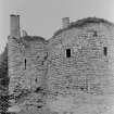
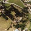
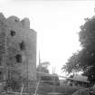
BUILDING PERIODS. Three main periods may be traced in the castle buildings c.13th, 15th and 16th centuries. In the 13th century the castle appears to have consisted of an enclosure formed by walls of enceinte following the perimeter of the site very much on the line of the walls now standing. The south-western angle contains the main building, which has towers semicircular and oblong, projecting outwardly (fig. 57). East of this the south wall is penetrated by the main entrance (fig. 58) and originally terminated at the southeast angle in a circular tower, of which only the lower portion remains. The lowest courses of another similar tower, which originally occupied the N.N.E. angle, have now (1924) been exposed. Later work overlies these, and a small circular tower has left foundations in the south. The existing ranges of building against the east. and south curtains were erected in the 15th century, but, as these structures appear to incorporate older buildings, particularly at the south-eastern angle, it is difficult to determine the exact chronology of the parts. The 16th century building comprises a structure- now forming the northern boundary of a court at the south-west angle with adjoining towers containing the staircases.
HISTORICAL NOTE. The lands of Dirleton and Gullane were possessed from about the middle of the 12th century by the family of De Vaux (Vallibus) (1). Their castle (castellum de Dyrlton) is specifically mentioned c. 1225 (2). In the summer of 1298, when Edward I was lying at 'Templehyston' (Kirkliston in Linlithgowshire), his foraging parties were being harassed by the Scots from Dirleton Castle, which the King had passed by on his march. He therefore sent the Bishop of Durham to capture the place. The first attacks were a failure owing to a deficiency of siege machines and of food. On the receipt of fresh supplies a further attack July 14-15 was successful, the garrison being allowed to go with their lives and property (3). In 1299 Robert de Maudlee was governor of ‘Driltone’ for Edward I (4) and in 1311 the place was still in English hands (5). Within the first half of the 14th century the castle and lands passed by marriage to the family of Halyburton, and in 1389 Sir John Halyburton had a protection from Richard II. of England for the castle and barony of ‘Drylton’ (6).
While in ward in the King's hands in 1363 it was seized by William, Earl of Douglas, as the first step in a revolt against David II. For misappropriation of public money (7). In 1505 James IV was at Dirleton and gave 28/ to the masons and workmen there - so that building was then going on (8). Early in the 16th century the Halyburton line in its turn ended in heiresses, of whom the eldest conveyed Dirleton to her husband's family, the Ruthvens, afterwards (1581) Earls of Gowrie (9). Robert Logan made Dirleton, which he esteemed ‘the pleasantest dwelling in Scotland’, the price of his co-operation in the ‘Gowrie Conspiracy’ in 1600. For the later history of the ownership see [RCAHMS 1924] Introd. p.xxi.
In 1650 ‘Derlingtoun (i.e. Dirleton) House’ was a nest of the moss-troopers who killed many soldiers of the army. Major-General Lambert and Colonel Monk with 1600 men came before the castle on November 7 and next morning opened fire from their batteries. The fourth shot (i.e. shell) of their mortar piece ‘tore the inner gate, beat down the draw bridge, and killed the lieutenant of the moss troopers’, whereupon the garrison surrendered ‘upon reverence’, being the governor, the captain of the moss-troopers and sixty soldiers. The captors ‘took in it many arms, sixty horses which they had taken from the English, and released ten English prisoners, and demolished the House’ (10).
[For further architectural description see the original publication].
RCAHMS 1924, visited June 1919; September 1924.
(1) Lib. de Dryburgh, Nos. 23, 29, 31, &c.;(2) Ibid, No. 37; (3) Hemingburgh's Chronicon in Annales Monastici (R.S.) iv., pp. 536-7; (4) Stevenson, Hist. Docts., ii., p. 401; (5) Bain's Calendar iii., No. 218; (6) Ibid, iv , p. 86; (7) Scalacronica, p. 203; Fordun, Gesta Annalia,clxxxiv.; (8) Accts. of L.H. Treas., iii., p. 161 ;(9) cf. R.M.S. s.a. 1529, No. 772, 1535-6 No.1553; (10) Whitelocke's Memorials (1732) p. 478.
Publication Account (1985)
Dirleton was described as a "castellum" c1225. Sited on a rocky, igneous outcrop at the east end of a gentle ridge and commanding the east-west coastal route, its principal structures were built by the de Vaux, an Anglo-Norman family granted the barony of Dirleton in the 12th century. In 1298, however, the castle was taken by Edward I.
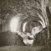
There are three main periods of construction. Most recent are the 16th century additions of the Ruthvens enclosing the inner court or close at the south -west corner. During the preceding two centuries, 14th and 15th, the Halyburtons had raised most of the east block-including cellars, bakery, kitchens and chapel. Below the chapel is a prison; below this, a pit-prison which, like others of the lower chambers, has been hewn out of the natural rock. The outer wall of this block was built against parts of the earlier curtain wall-re-used to provide further support for the new tunnel-vaulting. And the imposing main entrance and drawbridge also date to this period.
In its original form, however, Dirleton consisted of an enclosing wall or enceinte following very much the line of the present wall. Circular towers, now overlaid by later building, once occupied the south-east and north-north-east angles; in the south-west corner stood the main block, very much as it still is. Off the triangular inner court a semi-circular and a rectangular tower both project outwards; also the principal 'drum' tower of well-dressed masonry, with 3m thick walls to an overall diameter of some 11m. At first-floor level it contains the roughly hexagonal Lord's Chamber, with stone seats-three of them in window openings.
There is a 16th century beehive-shaped doocot in the grounds, and a 17th century bowling green whose surviving yew trees are a reminder of an earlier, formal planting within the 'garth'.
Dirleton is one of south-east Scotland's most attractive villages, and its present form can be traced back with certainty to the early 16th century.
Information from 'Exploring Scotland's Heritage: Lothian and Borders', (1985).
Watching Brief (July 2003)
NT 516 839 A watching brief was maintained in July 2003 during the excavation of a series of small shallow pits for a new fence line to run along the N and W sides of the High Green area, to the W of the Great Hall. There were no features or finds of archaeological significance.
Watching Brief (23 November 2004 - 3 December 2004)
In November and December 2004 Kirkdale Archaeology undertook a short Watching Brief for a hole dug for a tree at Dirleton Castle.
G Ewart 2004
Sponsor: Historic Scotland
Kirkdale Archaeology
Watching Brief (February 2005)
NT 5158 8393; NT 5158 8401 A watching brief was undertaken in February 2005 during the excavation of two substantial pits in the terraced areas to the N and W of the castle rock. These pits were to be used for the replanting of trees. There were no finds or features of archaeological significance.
Watching Brief (19 July 2011)
NT 5160 8393 and NT 5164 8392 A watching brief was maintained on 19 July 2011 during the excavation of two small trenches for new interpretation boards. One trench was located within the castle compound while the other was positioned adjacent to the present footbridge.
The trench within the castle (NT 5160 8393) revealed bedrock with no sign of weathering and was too uneven to represent the courtyard surface. The other trench (NT 5164 8392) appeared to be cut against an artificial terrace. The terrace presently defines the S edge of the main defensive ditch and also provides a platform for formal planting. The terrace may form part of the elaborate gardens associated with the 16th-century occupation of the site, which included a central parterre (presently a bowling green and a series of other compartments defined by low earthworks to the E and S). The terrace also serves to provide an access point to the bridge. Whether the rocky outcrop was complemented by a ditch in the 13th century is unknown. However, it is possible that the present terrace represents a rationalisation of a route leading up to an earlier bridge point, perhaps at a lower level.
Archive: RCAHMS (intended)
Funder: Historic Scotland
Kirkdale Archaeology 2011
Information also reported in Oasis (kirkdale1-122358) 25 February 2013
Watching Brief (23 May 2012 - 24 May 2012)
NT 5162 8396 A watching brief was maintained 23–24 May 2012 during the excavation of three trenches. The trenches were being dug to establish the composition of the deposits between the slab floor of the Great Hall of the Haliburton Range and the vault crown of the underlying cellars. A significant effort seems to have been made to try and consolidate the floor, probably in the early to mid-20th century, and this work involved the removal of the original infill deposits.
Archive: RCAHMS (intended)
Funder: Historic Scotland
Paul Fox, Kirkdale Archaeology 2012
OASIS ID: kirkdale1-310790
Watching Brief (16 October 2018)
NT 51594 83939 A watching brief was carried out, October 2018, at Dirleton Castle during the installation of a new steel barrier and handrail down the W side of the W stair stone steps leading up to the Close. No finds or features of archaeological significance were recorded.
Archive: NRHE (intended). Report: East Lothian HER
Funder: Historic Environment Scotland
Leah Watt ̶ CFA Archaeology Ltd
(Source: DES Vol 19)
OASIS ID: cfaarcha1-330988 (L Watt) 2018

