
Tantallon Castle


Castle (Medieval)
Site Name Tantallon Castle
Classification Castle (Medieval)
Canmore ID 56630
Site Number NT58NE 5
NGR NT 59587 85029
NGR Description Centred on NT 59587 85029
Datum OSGB36 - NGR
Permalink http://canmore.org.uk/site/56630


First 100 images shown. See the Collections panel (below) for a link to all digital images.
- Council East Lothian
- Parish North Berwick
- Former Region Lothian
- Former District East Lothian
- Former County East Lothian
NT58NE 5.00 59587 85029
NT58NE 5.01 5961 8501 dovecot
(NT 5959 8503) Tantallon Castle (NR) (Remains of)
(NT 5959 8509) Chapel (NR) (Site of)
(NT 5959 8504) Well (NR)
(NT 5961 8501) Dovecot (NR)
(NT 5960 8493) Tower (NR) (On NT 58 SE)
OS 6" map (1957).
See MoW official guidebook.
J S Richardson 1950.
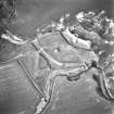
'Outside the (Tantallon) Castle are extensive earthworks, some of which represent the defences thrown up against the cannon of James V in 1526, while others, still further out, date from the Civil War'.
V G Childe and W D Simpson 1954.
The castle and its outworks are generally as described and illustrated above.
A short length of rubble-built wall on the edge of the cliff is all that remains of the crane-bastion noted by the authority; it is 5.6m. long, 0.6m. thick and was located at NT 5966 8478.
Earthworks revised at 1:2500.
Visited by OS (EGC) 15 November 1962.
REFERENCE:
Scottish Record Office.
Description taken from 'Geographia Blauina', vol.6 page 40-41, N.d. GD110/1174
National Library Uncatalogued MSS of General Hutton, Vol.1 no.25 - 1 sketch, 1782.
Nattes Drawings, Vol. IV, no.53 - 1 sketch.
Nattes Drawings, Vol. IV, nos. 46-52 - 7 drawings.
Sketches by Edward Duncan. MSS 3245 - sketch 1863.
NMRS REFERENCE:
Print Room:
Inglis Photograph Collection acc. no. 1994/90
2 different views, c.1930 or c.1940
Wood Sketch Book 1 - 1 sketch (restoration) - unlocated at time of upgrade.
Wood Sketch Book 2 - 1 sketch (gateway) - unlocated at time of upgrade.
Drawing - J.Drummond SAS 386 p.26 - unlocated at time of upgrade.
Field Visit (September 1924)
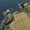
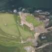
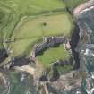
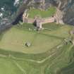
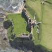
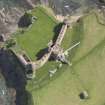
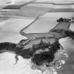
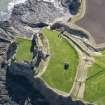
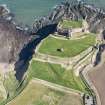
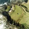
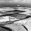
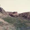
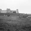
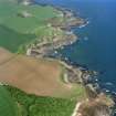
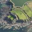
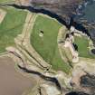
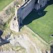
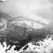
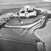
This castle, which is situated about 2 ½ miles east of North Berwick, is built on one of the many small promontories which, at this part of the coast line, project into the Firth of Forth. The site has been chosen with a view to economical fortification and is the most suitable in the vicinity for this purpose. The castle may briefly be described as consisting of a great screen wall thrown across the promontory between points where the cliffs, rising sheer from the sea to an elevation of some 100 feet, are quite unscaleable and enclose to seaward an oblong area measuring 250 feet from north north-west to south-south-east by 150 feet from east-north-east to west-south-west.
[See RCAHMS 1924, pp.61-67, for a full description of the outworks and castle buildings, and a lengthy historical note].
RCAHMS 1924, visited June 1919; September 1924.
Publication Account (1985)
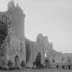
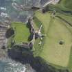
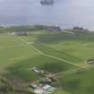
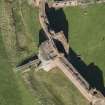
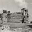
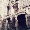
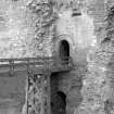
Tantallon's situation is spectacular, perched on a small but lofty sea-girt promontory. Though there may have been some kind of castle before 1300, the earliest reference to "Temptaloun" comes in 1374 from the 1st Earl of Douglas and Mar, who held the barony of North Berwick as a tenant of the Earls of Fife. With virtually unscaleable 30 m high sea-cliffs on three sides, Tantallon's curtain wall comprises a single, huge linear barrier of reddish sandstone, thrown across the landward side. Over 15m high and 3.6m thick, it is flanked by a D-shaped East Tower and a circular Douglas Tower with pit-prison.
In 1529 James V laid siege and battered the castle with cannons and other artillery. Surrender was finally agreed by negotiation rather than destruction, however, as the besiegers had run out of gunpowder (with further supplies apparently available only from France!). Then, in reinforcing the walls, James subsequently enlarged the Mid-Tower, thereby concealing the earlier drawbridge, portcullis and barbican.
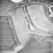
Beyond the ditch, extensive earthworks represent defences thrown up against the King's cannon; but others further out date from the mid 17th century. For here at Tantallon, during the English Civil War, 30 horsemen established themselves to harry Cromwell's lines of communication. General Monk attacked with cannon for 12 days in 1651 and very much reduced the flanking towers.
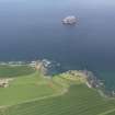
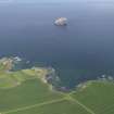
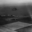
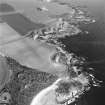
The main block of domestic buildings-hall, kitchen, bakehouse-lies north of the courtyard; also the remains of a sea-gate and probably of a landing stage in the bay immediately north-west of the castle. Outside the curtain wall, the 17th century rectangular doocot contains two chambers. Offshore lie the ruins of the 15th century St Baldred's Chapel and Bass Castle (NT 601872) - a largely ruinous structure dating in its present form from the 16th century. The lighthouse buildings are built on top of the governor's house. The Bass can be visited seasonally from North Berwick, and its innumerable breeding colonies of sea-birds- gannets, guillemots,puffins, gulls-make early summer a particularly interesting time: similarly the cliffs around St Abbs Head (NT 9169).
Information from 'Exploring Scotland's Heritage: Lothian and Borders', (1985).
Field Visit (18 February 1996)
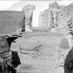
The castle lies on the cliff top, an outwork lies immediately on the edge of the cliff and is thus exposed to erosion. As this monument is in guardianship the state of its outworks is probably well known and was not dwelt on during this survey. There are reports of midden material having been visible below the castle. There are tussocks of material on rock below the castle but it would seem that much of this material has already been washed away. There may be pockets of material on the slopes below the castle.
Site recorded by GUARD during the Coastal Assessment Survey for Historic Scotland, 'The Firth of Forth from Dunbar to the Coast of Fife'
Watching Brief (2000)
NT 595 850 Archaeological monitoring was carried out in June 2000 while a minor excavation to provide the base for a new flagpole was carried out at the E end of the car park near the entrance to the Steward's office.
An early soil layer was revealed, now buried under 670mm of later landscaping layers, probably related to the construction of the Steward's office which is presumed to have been in the 1980s. No finds were retrieved.
Sponsor: Historic Scotland
D Stewart 2000.
Watching Brief (30 April 2008 - 1 May 2008)
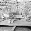
NT 5958 8502 A watching brief was maintained 30 April–1 May 2008 during the replacement of a section of clifftop fence to the N of the E tower. Part of a sandstone wall was revealed just N of the excavated postholes. This abutted the surviving portion of the E wall of the E tower and was probably a retaining wall. It was not fully excavated and its exact date remains uncertain.
Archive: RCAHMS (intended)
Funder: Historic Scotland
Sarah Hogg (Kirkdale Archaeology), 2008
Standing Building Recording (14 December 2009 - 22 December 2009)
In December 2009 Kirkdale Archaeology undertook a Standing Building Recording of the Gatehouse of Tantallon Castle. This included both the interior and exterior of the building.
G Ewart 2009
Sponsor: Historic Scotland
Kirkdale Archaeology
Standing Building Recording (8 February 2010 - 3 March 2010)
NT 5958 8502 A programme of standing building recording on elements of the gate tower was complemented by selective trenching at the base of the gate tower. The work recorded how the 14th-century tower was modified in the mid-16th century with new gun positions and also how the ditch profile was remodelled, in conjunction with further earthworks beyond the castle site. Most of the work was undertaken between 8–23 February 2010 during ongoing restoration and consolidation works by Historic Scotland.
D Murray 2010
Funder: Historic Scotland
Kirkdale Archaeology
OASIS ID: kirkdale1-279404
Project (5 March 2013 - 9 March 2013)
NT 59587 85029 Gradiometer and resistance surveys were carried out, 5–9 March 2013, over the Inner Close, the Outer Close and the Outer Defences. Both the surveys have identified a wide variety of anomalies of potential archaeological significance. Within the Inner Close well defined anomalies indicating possible building ranges have been detected. Within the Outer Close the data are more ephemeral. However, both the gradiometer and resistance datasets suggest a possible range of buildings immediately to the NW of the entrance to the castle. A perplexing cluster of anomalies, suggesting a series of stone packed postholes, has also been detected. Elsewhere less well defined anomalies have been noted which may be of archaeological significance. Data from the Outer Defences are dominated by a wide ditch outwith the ravelin and responses from earlier ridge and furrow cultivation.
Archive: Rose Geophysical Consultants
Funder: Historic Scotland
Susan Ovenden, Rose Geophysical Consultants, 2013
(Source: DES)
Earth Resistance Survey (5 March 2013 - 9 March 2013)
NT 59587 85029 Resistance survey.
Archive: Rose Geophysical Consultants
Funder: Historic Scotland
Susan Ovenden, Rose Geophysical Consultants, 2013
(Source: DES)
Magnetometry (5 March 2013 - 9 March 2013)
NT 59587 85029 Magnetometry survey.
Archive: Rose Geophysical Consultants
Funder: Historic Scotland
Susan Ovenden, Rose Geophysical Consultants, 2013
(Source: DES)
Excavation (8 May 2014 - 29 May 2014)
NT 5953 8500 (centred on) In the light of findings from a geophysical survey undertaken in 2013 (DES 2013, 73), further test trenching was undertaken 8–29 May 2014. This work followed on an initial evaluation in 2013 when seven trenches were excavated.
This second stage of evaluation consisted of the excavation of five main trenches and four shallow trial pits at various locations in and around the castle. The main trenches were placed to define and characterise a series of geophysical anomalies, which possibly reflected a range of archaeological contexts from various periods. The small trial pits were placed across the line of an active service trench (electricity) in order to establish its precise location. The findings from the five formal trenches can be summarised with broad phasing in each area as follows:
The Inner Close:
15th/16th century: Late medieval metalworking – smelting and casting.
16th/17th century: Clearance and backfill.
19th century: Levelling and landscaping.
The Outer Close:
15th/16th century: Stone building located towards the W limits of the promontory, possibly in association with a stone rampart/wall line.
16th century: Stone building cleared and levelled in order to create a clear field of fire towards the neighbouring promontory.
18th/19th century: Landscaping and clearance.
The Outer Defences:
12th–14th century: Rig cultivation.
Mid-16th century: Construction of the Ravelin/Spur plus associated earthworks – ditch and terraces.
Late-17th century: Trench and gun position constructed, earlier earthwork truncated on the E side.
Mid to late-19th century: Landscaping and the creation of a new access route.
Archive: RCAHMS (intended)
Funder: Historic Scotland
Gordon Ewart – Kirkdale Archaeology
(Source: DES)
Excavation (31 August 2015 - 24 September 2015)
NT 595 850 (centred on) A series of five trenches (18, 19, 20, 22 and 23) were excavated at various locations within and around Tantallon Castle, in August and September 2015, in order to test the results of previous geophysical survey across the site (DES 2013, 73).
Trench 18 (NT 5944 8492) revealed evidence of two phases of ditch construction. The first of these was defined as a possible early medieval defensive ditch. The cut of the early ditch was excavated to a depth of 2m and was 4m wide, most likely running across the neck of the promontory at the most westerly point. The cut ditch was complimented by an upcast earthen bank on its E and W sides. The ditch had been allowed to naturally backfill over time. Pottery evidence suggests this gradual infill occurred between the 12th – 14th centuries.
The second phase of activity in Trench 18 saw the partial re-cutting of the earlier ditch, making it wider, straighter and flat bottomed, with a total overall length of 125m. This work was augmented with the addition of a series of well preserved turf structures. The finished work is most likely part of the mid-17th-century siege-works. The turf structures comprised: a wide, flat-topped rampart to the E, over the Phase 1 eastern bank; a revetment against the re-cut inner faces of the E and W Phase 1 banks; low walls at the E and W sides of the ditch base; and a walking surface across the flat base of the ditch. There was also evidence of timberwork (posts) along the western side of the outer (eastern) rampart.
Trench 19 (NT 5951 8506) cut across the line of a multiphase, heavily eroded bank with four associated phases of landscaping/dumping, all overlying a stone capped, channellike feature. Phase 1 was defined by a partially exposed dry stone structure – a possible drain or flue (as yet undated). Phase 2 was defined by a dry stone revetting wall and low earthwork, demarcating a bank/boundary aligned roughly E/W and associated with dumped material to the N. This phase probably dates to the 14th – 15th centuries. Phase 3, dating to the 16th – 17th centuries, saw the early earth bank/ boundary heightened and widened with further dumped soils as part of a more general landscaping exercise which extended northwards of the earlier bank. The bank itself survived, although heavily eroded, as the N side of a low terrace or platform. Finally, Phase 4 saw the northern area of low earthworks sealed by dumped 20th-century debris, probably reflecting clearance works across the site.
Trench 20 (NT 5953 8506) was intended to develop further the results of previous work (in 2014) where evidence of a stone structure, featuring recycled masonry, had been revealed. The present work revealed four phases of activity, with Phase 1 defined by evidence of stone cutting/dressing associated with a possible timber enclosure, dating to the 14th – 15th centuries. Phase 2 saw the construction of a stone enclosure or building featuring a possible gun position looking NW. The gun position featured recycled dressed ashlar in its fabric, and the stone structure lay to the N of an earthen bank or terrace. This phase was dated to the 16th century. Phase 3 was defined by the reduction of a stone building to foundation level; the foundation was then sealed by an earthwork platform or truncated bank. Phase 3 was dated to the 16th – 17th centuries. The final phase, Phase 4, was defined by 20th-century landscaping and maintenance.
Trench 22 (NT 5961 8502) cut across the remains of post-medieval garden activity, which in turn appear to have either truncated or sealed evidence of a sequence of ranges (14th – 16th century) abutting the inner face of the west curtain wall. The planting evidence comprised a shallow linear bed and a larger single plant pit, all cut against a clay-rich basal deposit. This may in turn reflect the truncated footings of at least two phases of a stone and timber range, or the construction of the western side of a mineral parterre in the 17th century.
The final trench excavated, Trench 23 (NT 5963 8503), revealed the well-preserved evidence of a low bank, parallel with the line of the southern curtain wall. The bank comprised three elements: a flat, stony upper surface, a shallow scarp, and a flat platform. The latter elements were both defined by well preserved cut turf forming a decorative surface. It is possible that this feature forms one side of a 17th-century square mineral parterre, covering most of the southern half of the inner close.
Gordon Ewart 2015
Funder: Historic Scotland
Kirkdale Archaeology
Watching Brief (20 July 2015)
An archaeological watching brief was maintained during the installation of new signage and replacement of interpretation panels. Surfaces of anthropomorphic origin were revealed in the trenches at NT 5952 8497 and NT 5964 8503. These were not excavated and were left undisturbed. There were no other finds or features of archaeological significance.
Information from OASIS ID: kirkdale1-311412 (G Ewart) 2015
Ground Penetrating Radar (25 November 2015 - 28 November 2015)
NT 59587 85029 A programme of geophysical survey was carried out in 2013 which identified a wealth of significant anomalies, many of which have been targeted in subsequent excavations. A ground penetrating radar (GPR) survey has been carried out, 25–28 November 2015, over selected areas to further refine and inform interpretation.
Within the outer close several trends and ephemeral anomalies suggestive of a possible broad ditch on an E/W alignment are evident within the N of the area. The data also suggests remnants of possible rig and furrow cultivation. Given these discrete anomalies and broader areas of increased response, it appears that some of the anomalies detected in the previous resistance survey may be the result of different phases of activity, rather than contemporaneous features.
Although numerous very strong anomalies have been detected within the ravelin area, many are associated with the extant earthworks. Variations in response over the ravelin bank may indicate areas of reconstruction. The survey has added more information regarding potential features within
the ravelin. However, the data from the outer ditch is not conclusive. No clear profile is evident suggesting a very shallow feature.
Survey of the crossing points over the main ditch behind the ravelin proved disappointing. There are no clear suggestions of structures within these earthworks consistent with buried caponiers. However, the survey may have revealed an earlier profile of the northern crossing point and the lack of response from the southern crossing point may itself be significant.
Archive: Rose Geophysical Consultants
Funder: Historic Environment Scotland
Susan Ovenden – Rose Geophysical Consultants
(Source: DES, Volume 17)

