
Following the launch of trove.scot in February 2025 we are now planning the retiral of some of our webservices. Canmore will be switched off on 24th June 2025. Information about the closure can be found on the HES website: Retiral of HES web services | Historic Environment Scotland
North Berwick, Harbour


Harbour (18th Century)
Site Name North Berwick, Harbour
Classification Harbour (18th Century)
Alternative Name(s) North Berwick Harbour
Canmore ID 56601
Site Number NT58NE 22
NGR NT 55343 85610
Datum OSGB36 - NGR
Permalink http://canmore.org.uk/site/56601


- Council East Lothian
- Parish North Berwick
- Former Region Lothian
- Former District East Lothian
- Former County East Lothian
NT58NE 22.00 55343 85610
NT58NE 22.01 NT 5530 8558 SW Pier, Hand Crane
NT58NE 22.02 NT c. 5527 8558 Leading Light (Beacon)
NT58NE 22.03 NT c. 5535 8568 Leading Light (Beacon)
NT58NE 22.04 NT 55299 85582 to NT c. 55323 85565 SW Pier
NT58NE 22.05 NT 55274 85579 to NT c. 55360 85651 N Pier
For (putative) predecessor landing-place (NT c. 5535 8560), see NT58NE 4.
For (associated) former warehouses (NT 55347 85566), see NT58NE 45.
For swimming pool (adjoining, to NE), see NT58NE 54.
For Scottish Seabird Centre (adjacent, to E), see NT58NE 191.
For (former) boatbuilding yard (adjoining, to E), see NT58NE 192.
Harbour [NAT] (centred NT 55346 85609)
OS (GIS) NAT, July 2006.
NMRS REFERENCE
Designed by Robert Stevenson c. 1816.
EXTERNAL REFERENCE
Scottish Record Office
Letter from George Ritchie to Hugh Dalrymple concerning an inspection of the Harbour with a view to its improvement.
1787 GD110/1551
Anon to anon.
Asking for a note of the agreement. The work concerns the north pier head up to the cross Pier and is to cost #300.
New pier to be built for #120.
Stones to be brought from North Berwick Law.
No date GD110/1132
(Undated) information in NMRS.
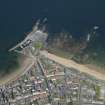
(Location cited as NT 553 855). North Berwick, East Lothian. Between the East and West Bays at North Berwick there projects into the Firth a mass of rock, formerly a small tidal island joined to the mainland by a bridge. On it stood the old church of St Andrew [NT58NE 3.00] and a hospital for pilgrims [NT58NE 21]. The latter, like its counterpart at Earlsferry [NT49NE 3] on the Fife coast, was founded in the 12th century by Duncan, Earl of Fife. Along the NW side of the island, and separated from it by a narrow tidal channel aligned from NE to SW, there lies the Plattock reef, a straightish ridge of rock which rises above high-water mark. The harbour has been formed, and brought to its present condition over the years by building a breakwater along the crown of the ridge so as to flank the channel, cutting off the wider (SW) portion of the channel from the rest, with a transverse work, partially closing its SW end, and improving the interior with wharfage. Adair's record (1703) of a harbour on the W side of the island 'within a Peir of Stone' would correspond with the first or second stage of this process.
The harbour is clearly very old. 'Ports' at each end of the pilgrims' ferry to Fife are mentioned in a charter of 1777, travellers were crossing to Earlsferry in 1304, commercial use is referred to in 1373, North Berwick being by that time a free port, and a novodamus charter of 1658 implies that a 'haven' had existed in an indefinitely distant past. But although records on the harbour are fairly numerous, no clear picture emerges of the actual stages by which the works developed, as more recent construction inevitably has disguised the evidence for earlier phases and the records are not always lucid. Apart from the features mentioned in the next two paragraphs, there is nothing in the general appearance of the harbour to suggest a date earlier than the 18th century.
The breakwater, in the first place, presents a sharp contrast to the rest of the works, its NE portion consisting, in the main, of boulders and large, rough blocks. These may in pl. 31a, together with a patch of squared masonry said locally to have been inserted in 1898 to repair damage by a storm. Messrs. Robert Stevenson and Sons remarked in 1812 on the breakwater's rude workmanship and its appearance 'of great age'. Its alignment is slightly sinuous, its top, 12ft [3.7m] to 15ft [4.6m] is uneven, and its outer face is of irregular dry-stone masonry secured with wooden wedges. This type of stonework may be matched, on this part of the coast, only in the East Pier at Dunbar [Dunbar, Old Harbour: NT67NE 18], where a date in the late 16th century is suggested, and where wedges were also built. It ends about 50ft [15.2m] short of the harbour-entrance, beyond which point the breakwater has been rebuilt.
The pier that closes the inner (NE) end of the harbour, separating it from what is now a swimming-pool [NT58NE 54] goes back at least to the first quarter of the 18th century, and very possibly earlier. This 18th century date is established by references to a sluice, or sluices, in the Burgh Treasurer's accounts of 1726 and later, their purpose being to wash silt out of the harbour and their position in the transverse pier being vouched for by Robert Stevenson in 1811. No structure, however, can be seen today which suggests a comparable date, and in fact a sketch made in 1885 shows that, before the swimming-pool was formed, the wall that backed the pier consisted of stone-work similar to that in the most recent parts of the harbour, and consequently, if this pier ever bore any distinctively early features, they must have been obliterated by later additions and alterations.
To come down to the most recent works, the harbour as it stands is sub-rectangular in shape, and measures from 270ft [82.3m] to 306ft [93.3m] in length by 102ft [31.1m] to 110ft [33.5m] in breadth. It encloses an area of just over two-thirds of an acre [0.27ha], which dries out completely at low water. Its general arrangement, of wharves faced with squared and coursed blocks of red igneous stone, is naturally due to the most recent repairs and additions, particularly those called for by storm-damage suffered in 1788, 1802 and 1811, but a sketch-plan in Robert Stevenson's note-book, drawn when he was inspecting the damage of the last of these storms, shows that the quays were then laid out just as they are today, although the breakwater may have been somewhat lengthened in the reconstruction that followed..
In the disaster of 1811, the outer end of the breakwater was levelled almost to the ground for a length of 88ft [26.9m], while the SW pier on the opposite side of the entrance, was also so badly shattered that the uppermost 6ft [1.8m] of its height needed relaying. The renewed SW portion of the breakwater contains some pulvinated work and a string-course, both rather reminiscent of the revetment behind the harbour at South Queensferry [NT17NW 71.00], and the parapet ends, at the pier-head, in a small roundel the top of which is reached by a stair. The NW quay varies in breadth from 12ft [3.7m] to 30ft [9.1m] owing to the sinuosity of the old part of the breakwater, which rises above it, as a parapet, to the greatest height of 8ft 6ins [2.6m]. On this quay there area some very large pawls cut from the local red stone, the largest of which measures 4ft 6ins [1.4m] in height by 1ft 2ins [0.36m] in diameter at the top, and has a roughly quadrangular base 1ft 10ins [0.56m] a side. There is another similar one on the SE quay. Stone pawls up to 9ft [2.7m] in overall length are mentioned in Burgh records in 1770, this dimension evidently including a base to be sunk deeply into the wharf. The SE quay may well be the 'new quay' mentioned in the Burgh records in 1788; from its SW end a flight of steps descends to the sands of the West Bay. The SW transverse pier, at the outer end of the harbour, was presumably the 'cross-pier' contracted for in 1802, as the only other 'cross' structure, the NE pier, had been in existence long before. The harbour-entrance, which opens between the head of the SW pier and the main breakwater, is 25ft [7.6m] wide, and has chases and a crane for booms. The booms were installed in 1806 and were held to improve the safety of the harbour, but Messrs Stevensons' report states that they contributed to the disaster of 1811 by increasing the pressure on the SW pier. Steps to the harbour-bottom are provided in the N and S corners, and also on the SE side. Cut-back rock-faces appearing here and there under the quays show where encroaching rocks have had to be removed, and the deepening of the harbour is recorded more than once, eg. in 1804 Messrs Grieves and Bamber, of North Berwick, estimated for deepening and building, and in 1862 J Young of Sunderland deepened the whole harbour to the depth of the entrance.
Associated with the harbour was a yard [NT58NE 192] where boats were repaired or laid up. This seems to have occupied a position immediately SE of the swimming-pool, and to have been approached by way of a slip in the harbour's E corner, where a mass of rock has been cut away. The slip, but not the yard, is shown in Robert Stevenson's note-book, and also in a plan produced by his form in 1861. The site of the swimming-pool is marked 'Basin' in the note-book, and Messrs Stevenson suggested enlarging the harbour in this direction, but the proposal was not taken up.
[Sources and authorities cited].
A Graham 1971.
As described above. There are no obvious remains of medieval fabric visible.
Visited by OS (SFS) 8 July 1975.
(Location cited as NT 553 856). North Berwick Harbour, mainly 19th century. A rectangular basin. formed by an E pier and an 18th century W breakwater, with quays on the landward side. There are a pair of 18th-century, 3-storey warehouses [NT58NE 45], now converted to other uses.
J R Hume 1976.
North Berwick Harbour is still in use and is well maintained. The hand crane still stands on the end of the north breakwater.
Site recorded by GUARD during the Coastal Assessment Survey for Historic Scotland, 'The Firth of Forth from Dunbar to the Coast of Fife' 18th February 1996.
Photographic Survey (April 1959)
Photographic survey by the Scottish National Buildings Record in April 1959.

