Scheduled Maintenance
Please be advised that this website will undergo scheduled maintenance on the following dates: •
Tuesday 3rd December 11:00-15:00
During these times, some services may be temporarily unavailable. We apologise for any inconvenience this may cause.
Haddington, Bothwell Castle
Dovecot (16th Century) - (17th Century), Town House (16th Century) - (17th Century)
Site Name Haddington, Bothwell Castle
Classification Dovecot (16th Century) - (17th Century), Town House (16th Century) - (17th Century)
Canmore ID 56552
Site Number NT57SW 6
NGR NT 5170 7409
Datum OSGB36 - NGR
Permalink http://canmore.org.uk/site/56552
- Council East Lothian
- Parish Haddington
- Former Region Lothian
- Former District East Lothian
- Former County East Lothian
NT57SW 6 5170 7409.
(NT 5170 7409) Bothwell Castle (NR)
OS 6" map (1957)
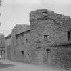
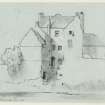
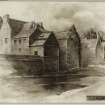
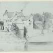
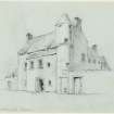
Bothwell Castle is a late 16th or early 17th century town house, now in ruins. On plan it consisted of a main block running N-S and two wings which extended E to the river, thus enclosing a small courtyard. A circular tower projected at the front SW angle, while at the E end of the S wing was a rectangular dovecot integral with the wall.
(RCAHMS 1924, visited 1913; A N Robertson 1952)
The remains of this house and dovecot were demolished in 1955 and the site converted into a small public park.
Visited by OS (BS) 10 July 1975
NMRS REFERENCE:
Bothwell Castle Doocot which was Category B Listed was demolished c. 1950s. Information from Demolitions catalogue held in RCAHMS Library.
Field Visit (19 July 1913)
'Bothwell Castle'
The ruin of this town house, which dates from the late 16th or early 17th century, occupies a site on the left bank of the River Lyne 100 yards below the new bridge. It covers a considerable area, extending from the river bank to East Gate Street, which is the main access to the town from the east. Fig. 87 [RCAHMS 1924] shows the condition of the structure in 1897, while fig. 86 [SC 1127009], taken in 1913, shows its present state of ruin.
On plan the structure consisted of a main block running north and south parallel to the street and two wings; which extended eastwards to the river and enclosed a small courtyard. At the south-west angle of the frontage there projects a circular tower, in which was placed the main entrance. Above this is a weather worn armorial panel within the usual moulded border. The entrance in the tower has long been built up and superseded by a doorway more conveniently placed in the centre of the main block. This main block contained a sunk floor, two upper floors and an attic. The area is reached from the street level by a staircase within the tower, and it is probable that this stair originally continued upwards and gave access to the upper floors before the erection of a wide scale and platt staircase built out on the courtyard between the wings. The wings were three storeys high and were also served by this later staircase. At the eastern end of the south wing there was a rectangular dovecot, not detached but forming a portion of the main structure.
The walls are built of rubble with ashlar dressings. The window and door jambs are moulded in some instances, splayed in others. The interior of the building was finished with care and taste. A drawing dated 1897 and preserved in the National Art Survey of Scotland records the interior wood panelling of one room and the iron door-fittings.* These all appear to have been excellent examples of native craftsmanship. This structure, less than thirty years ago, was one of the best specimens of old Scottish domestic town architecture.
RCAHMS 1924, visited 19 July 1913.
*[HES hold a copy as ELD 58/1]
Publication Account (1978)
One of the finest townhouses Haddington boasted was Bothwell Castle, which belonged to the Cockburns of Sandybed and dated possibly from the late sixteenth century . Situated on the left bank of the Tyne below the new bridge, Bothwell Castle was ruinous by the turn of the century and was taken down in 1966.
Information from ‘Historic Haddington: The Archaeological Implications of Development’ (1978).
Excavation (15 September 2013 - 22 September 2013)
NT 51700 74089 A programme of community archaeology was undertaken, 15–22 September 2013, as part of the Peter Potter Gallery Monument Project. This work was supported by East Lothian Council Archaeology Service and brought together 11 schools and over 200 local people to excavate in Hardgate Park on the site of ‘Bothwell Castle’.
Bothwell Castle is a late 16th- or early 17th-century town house, which consisted of a main block running N–S and two wings which extended E to the river, enclosing a small courtyard. A circular tower projected at the front SW angle, while at the E end of the S wing was a rectangular dovecot integral with the wall.
Excavation in the upper levels showed the building is still upstanding (2–2.5m high) towards the river and the courtyard is intact to ground floor level. The vaulted kitchen chamber has lost the vaulting and the cellar has been filled with rubble hardcore. A doorway and window sills were uncovered, but the building was demolished to ground level in 1952.
The lower river walkway is buried beneath over 1.5m of sand; however, examination of the river wall confirmed the presence of a range of structures along Hardgate, which is now parkland. These include a complete set of post 1548 Siege town houses and hints that some of these may have foundations that date to the 16th century or earlier.
Archive: Connolly Heritage Consultancy and RCAHMS
Funder: Connolly Heritage Consultancy and Peter Potter Gallery/HLF
David Connolly, Connolly Heritage Consultancy, 2013
(Source: DES)


