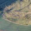
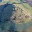
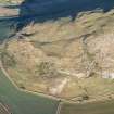
Accessibility

Font Size

100% 150% 200%

Background Colour

Default Contrast
Close Reset

Traprain Law

Cairn (Prehistoric)

Site Name Traprain Law

Classification Cairn (Prehistoric)

Canmore ID 56486

Site Number NT57SE 87

NGR NT 58165 74670

Datum OSGB36 - NGR

Permalink http://canmore.org.uk/site/56486

Ordnance Survey licence number AC0000807262. All rights reserved.
Canmore Disclaimer. © Bluesky International Limited 2025. Public Sector Viewing Terms

Toggle Aerial | View on large map

Digital Images

Oblique aerial view centred on the remains of the fort and cairn, taken from the SW.
Oblique aerial view centred on the remains of the fort and cairn, taken from the SW.Plan and sections of Traprain Law showing archaeological features (1:1000). Oblique aerial view centred on the remains of the fort and cairn, taken from the SW.Oblique aerial view centred on the remains of the fort and cairn, taken from the S.Traprain Law, NT57SE 87, Ordnance Survey index card, RectoOblique aerial view.Oblique aerial view centred on the remains of the fort and cairn, taken from the SW.Traprain Law, NT57SE 87, Ordnance Survey index card, RectoOblique aerial view centred on the remains of the fort and cairn, taken from the NW.Product: DSM slope visualisation (8 bit tiff), Traprain LawOblique aerial view.Oblique aerial view centred on the remains of the fort and cairn, taken from the NW.Oblique aerial view.Oblique aerial view centred on the remains of the fort and cairn, taken from the N.Simplified plan of Traprain Law fort showing the principal phases of enclosure (1:10,000).

Administrative Areas

  • Council East Lothian
  • Parish Prestonkirk
  • Former Region Lothian
  • Former District East Lothian
  • Former County East Lothian

Archaeology Notes

NT57SE 87 581 746.

'Immediately to the north of the trigonometrical station on the summit of the hill (NT57SE 1.00) there are also the remains of a cairn which, though well robbed, gives the appearance of having been a genuine sepulchral monument.'

G Jobey 1976

Activities

Field Visit (26 April 2017)

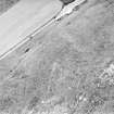
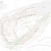
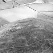
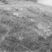
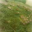
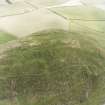
On the summit of Traprain Law, underlying the modern walker’s shelter (NF57SE 176), there is a rubble spread measuring about 7m in diameter by 0.2m in height. Depicted by RCAHMS in 1955 and discussed by George Jobey (1976, 192-3), it is likely to represent cleared rubble from successive survey or marker cairns, or the adjacent enclosures, rather than being the remains of a sepulchral monument.

Visited by HES Survey and Recording (GFG) 26 April 2017.

(TPR15)

References

MyCanmore Image Contributions


Contribute an Image

MyCanmore Text Contributions