Accessibility

Font Size

100% 150% 200%

Background Colour

Default Contrast
Close Reset

Whitelaw Hill

Fort (Prehistoric)

Site Name Whitelaw Hill

Classification Fort (Prehistoric)

Canmore ID 56407

Site Number NT57SE 17

NGR NT 57186 71563

NGR Description Centre

Datum OSGB36 - NGR

Permalink http://canmore.org.uk/site/56407

Ordnance Survey licence number AC0000807262. All rights reserved.
Canmore Disclaimer. © Bluesky International Limited 2025. Public Sector Viewing Terms

Toggle Aerial | View on large map

Digital Images

Oblique aerial view of the cropmarks of the fort and pit alignment on Whitelaw Hill, taken from the E.
Oblique aerial view of the cropmarks of the fort and pit alignment on Whitelaw Hill, taken from the E.General oblique aerial view of the cropmarks of the fort and pit alignment on Whitelaw Hill, taken from the NNW.Oblique aerial view of the cropmarks of the fort and pit-defined boundary, looking E.Oblique aerial view.Oblique aerial view.Oblique aerial view.Oblique aerial view of Whitelaw Hill centred on the remains of a fort.  Taken from the ENE.Oblique aerial view.Oblique aerial view centred on the cropmarks of the fort and pit-alignment, taken from the WSW.Oblique aerial view centred on the cropmarks of the fort and pit-alignment, taken from the SE.Oblique aerial view.Oblique aerial view.Oblique aerial view of the cropmarks of the fort and pit-defined boundary, looking NE.Oblique aerial view of Whitelaw Hill taken from the NNE, centred on the cropmarks of a fort. A pit-alignment is visible in the centre left half of the photograph.Oblique aerial view of Whitelaw Hill taken from the NNW, centred on the cropmarks of a fort. A pit-alignment is visible in the centre left half of the photograph.Oblique aerial view of Whitelaw Hill taken from the NW, centred on the cropmarks of a fort. A pit-alignment is visible in the top left half of the photograph.Oblique aerial view of Whitelaw Hill taken from the SW, centred on the cropmarks of a fort.Oblique aerial view of Whitelaw Hill centred on the remains of a fort.  Taken from the NE.Oblique aerial view.Oblique aerial view.Oblique aerial view.Oblique aerial view centred on the cropmarks of the fort with the cropmarks of the pit-alignment adjacent, taken from the ESE.Oblique aerial view centred on the cropmarks of the fort with the cropmarks of the pit-alignment adjacent, taken from the E.Oblique aerial view centred on the cropmarks of the fort and pit-alignment, taken from the WNW.Oblique aerial view centred on the cropmarks of the fort and pit-alignment, taken from the NNW.Oblique aerial view centred on the cropmarks of the fort and pit-alignment, taken from the SW.Oblique aerial view of Whitelaw Hill taken from the NW, centred on the cropmarks of a fort. A pit-alignment is visible in the top left half of the photograph.Oblique aerial view of the cropmarks of the fort and pit alignment on Whitelaw Hill, taken from the ENE.Oblique aerial view of the cropmarks of the fort and pit-defined boundary, looking E.Oblique aerial view of the cropmarks of the fort and pit-defined boundary, looking NE.Oblique aerial view.Oblique aerial view.Oblique aerial view.Oblique aerial view.Oblique aerial view of Whitelaw Hill taken from the SSE, centred on the cropmarks of a fort. A pit-alignment is visible in the centre right half of the photograph.Oblique aerial view.Oblique aerial view.Oblique aerial view centred on the cropmarks of the fort and pit-alignment, taken from the SE.Oblique aerial viewWhitelaw Hill, NT57SE 17, Ordnance Survey index card, page number 2, VersoWhitelaw Hill, NT57SE 17, Ordnance Survey index card, page number 1, RectoOblique aerial view of the cropmarks of the fort and pit alignment on Whitelaw Hill, taken from the S.Oblique aerial view.Oblique aerial view of Whitelaw Hill centred on the remains of a fort.  Taken from the SW.Oblique aerial view.Oblique aerial view.Oblique aerial view centred on the cropmarks of the fort and pit-alignment with the settlement adjacent, taken from the WSW.Oblique aerial view centred on the cropmarks of the fort and pit-alignment, taken from the SW.Oblique aerial view of the cropmarks of the fort and pit-defined boundary, looking ENE.Oblique aerial view.Oblique aerial view.Oblique aerial view.Oblique aerial view of Whitelaw Hill taken from the NE, centred on the cropmarks of a fort. A pit-alignment is visible in the centre left half of the photograph.Oblique aerial view of Whitelaw Hill taken from the SW, centred on the cropmarks of a fort.Oblique aerial view of Whitelaw Hill taken from the SW, centred on the cropmarks of a fort.Oblique aerial view.Oblique aerial view.Oblique aerial view centred on the cropmarks of the fort with the cropmarks of the pit-alignment adjacent, taken from the SSW.Oblique aerial viewOblique aerial view.Oblique aerial view.Oblique aerial view.Oblique aerial view.Oblique aerial view.Oblique aerial view.Oblique aerial view.Oblique aerial view.Oblique aerial view.Oblique aerial view.Oblique aerial view.Oblique aerial view of Whitelaw Hill taken from the S, centred on the cropmarks of a fort.Oblique aerial view.Oblique aerial view.Oblique aerial view centred on the cropmarks of the fort with the cropmarks of the pit-alignment adjacent, taken from the ENE.Oblique aerial view centred on the cropmarks of the fort and pit-alignment, taken from the WNW.Oblique aerial view of the cropmarks of the fort and pit alignment on Whitelaw Hill, taken from the ESE.Oblique aerial view of the cropmarks of the fort and pit alignment on Whitelaw Hill, taken from the NE.Oblique aerial view of Whitelaw Hill centred on the remains of a fort.  Taken from the WSW.Oblique aerial view.Oblique aerial view.Oblique aerial view centred on the cropmarks of the fort with the cropmarks of the pit-alignment adjacent, taken from the SE.Oblique aerial view centred on the cropmarks of the fort and pit-alignment with the settlement adjacent, taken from the W.Oblique aerial view.Oblique aerial view.Oblique aerial viewOblique aerial view.Whitelaw Hill, NT57SE 17, Ordnance Survey index card, RectoWhitelaw Hill, NT57SE 17, Ordnance Survey index card, RectoWhitelaw Hill, NT57SE 17, Ordnance Survey index card, Recto

Administrative Areas

  • Council East Lothian
  • Parish Whittingehame
  • Former Region Lothian
  • Former District East Lothian
  • Former County East Lothian

Archaeology Notes

NT57SE 17 NT 57185 71557

(NT 5719 7157) Fort (NR) (site of)

OS 6" map (1969)

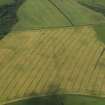
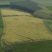
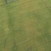
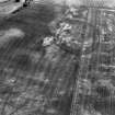
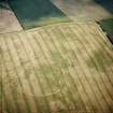
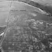
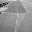
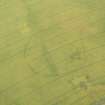
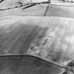
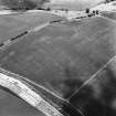
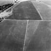
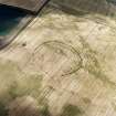
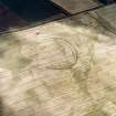
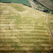
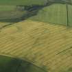
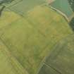
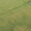
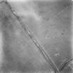
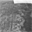
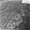
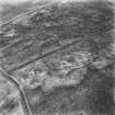
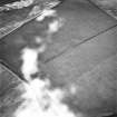
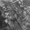
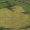
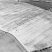
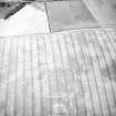
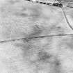
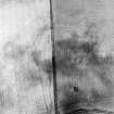
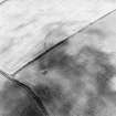
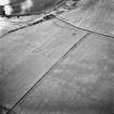
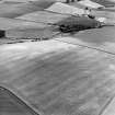
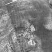
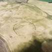
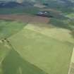
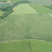
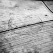
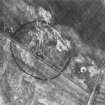
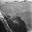
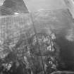
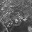
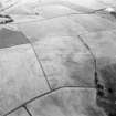
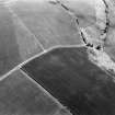
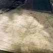
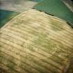
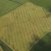
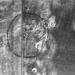
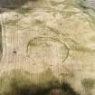
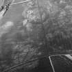
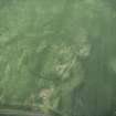
Fort, Whitelaw Hill: This circular fort, with double or possibly triple, ditches and an internal diameter of about 350ft, is evidenced by a cropmark on the hill summit (CPE/Scot/UK257: 3133-4).

RCAHMS Marginal Lands MS 1954

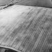
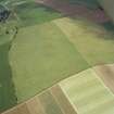
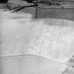
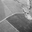
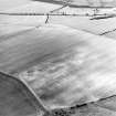
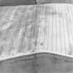
This fort has been completely ploughed out and no trace is now visible on the ground.

Surveyed at 1:2500 from RAF AP's.

Visited by OS (RD) 22 March 1965

Further aerial photographs of this fort have been taken by the RCAHMS in 1976, 1977, 1979, 1980, 1986, 1989, 1992, 1994 and 1995. Also visible on CUCAP air photographs.

(Undated) information in NMRS.

Scheduled as Whitelaw Hill, enclosure.

Information from Historic Scotland, scheduling document dated 20 June 1994.

Activities

Aerial Photographic Interpretation (6 May 1954)

Fort, Whitelaw Hill.

A circular fort with double, possibly triple, ditches, and an internal diameter of about 350 ft, on the summit of Whitelaw Hill (1).

(1) CPE/Scot/UK 257, 3133-4.

Information from RCAHMS (KAS) 6 May 1954.

Reference (1957)

This site is noted in the ‘List of monuments discovered during the survey of marginal land (1951-5)’ (RCAHMS 1957, xiv-xviii).

Information from RCAHMS (GFG), 24 October 2012.

Note (16 December 2015 - 18 May 2016)

This fort is situated on the southern shoulder of the broad summit of Whitelaw Hill. Slightly oval on plan, it measures 138m from NE to SW by 125m transversely (0.14ha) within a single ditch up to 4m in breadth; allowing for the presence of an internal rampart, the interior would have extended to about 1.16ha. No trace of the rampart is visible as such, but a faint ring of irregular marks within the line of the ditch are possibly traces of shallow quarries to the rear of the rampart; no other features are visible within the interior. There are clearly defined entrances on the SW and WNW, and probably two others on the NE and ESE respectively. The pit-alignments that approach obliquely from the E and W suggest that the perimeter of the fort may have been subsequently incorporated into a land boundary, as is the case with at least one other iron age enclosure in East Lothian.

Information from An Atlas of Hillforts of Great Britain and Ireland – 18 May 2016. Atlas of Hillforts SC3876

Note (11 December 2019)

The location, classification and period of this site have been reviewed.

References

MyCanmore Image Contributions


Contribute an Image

MyCanmore Text Contributions