
Sixpence Strip


Palisaded Settlement (Later Prehistoric)
Site Name Sixpence Strip
Classification Palisaded Settlement (Later Prehistoric)
Alternative Name(s) Maskinside
Canmore ID 56303
Site Number NT57NW 30
NGR NT 50282 78374
Datum OSGB36 - NGR
Permalink http://canmore.org.uk/site/56303


- Council East Lothian
- Parish Athelstaneford
- Former Region Lothian
- Former District East Lothian
- Former County East Lothian
NT57NW 30 NT 502820 78374
NT 502 785. There is the ditch of a circular enclosure about 160' in diameter, at the back of Maskinside.
RCAHMS MSS 1956
Maskinside is at NT 5036 7834. There is no trace of an enclosure in a cultivated field behind the house.
Visited by OS (BS) 16 July 1975
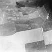
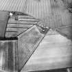
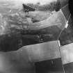
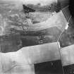
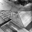
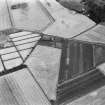
NT 503 783. Settlement, Sixpence Strip: visible on aerial photographs.
(Undated) information in NMRS.
Scheduled as Sixpence Strip, enclosure.
Information from Historic Scotland, scheduling document dated 1 November 1993.
Aerial Photographic Interpretation (25 October 1954)
The following remains are visible as crop-markings on a series of air-photographs which were taken by the Royal Air Force in 1930, at the request of the late Dr J Graham Callander, and are now preserved in the Commission’s archives.
Enclosure, Maskinside.
The ditch of a circular enclosure, about 160 ft in diameter, at the back of Maskinside a quarter of a mile WNW of the Chesters fort, Drem.
Information from RCAHMS (KAS) 25 October 1954.
Magnetometry (August 2000 - January 2002)
Geomagnetic surveys have been carried out over a sample of 30 cropmark sites in the vicinity of Traprain Law, comprising Phase 1 of the Traprain Law Environs Project.
In the majority of cases (23 out of 30), the surveys have confirmed the presence on the ground of the enclosures shown on aerial photographs, often with very clear results. In a number of cases, the surveys have produced evidence of probable internal and/or external features which were not immediately visible on air photographs, while in other cases, the presence of these additional features has been confirmed. Several of the sites investigated appear to represent more than one phase of archaeological activity.
In the 7 cases where cropmark sites have not been readily identified, this appears to be due to a number of factors. In only one instance does the underlying igneous geology appear to be the main factor; while in several cases, anomalies not immediately relatable to the previous cropmarks were detected and might well prove be of archaeological significance.
The work reported here brings to a conclusion Phase 1 of the Traprain Law Environs Project.
Archive to be deposited in the NMRS.
Sponsors: Historic Scotland, University of Durham, and Dickinson College, Pennsylvania.
Duncan Hale and Colin Haselgrove.
Project (2000 - 2004)
A project investigating the nature and development of later prehistoric and Roman Iron Age settlement in a 15 by 10 km block of landscape around the major fortified hilltop site at Traprain Law in East Lothian.
Note (26 September 2022)
The location, classification and period of this site have been reviewed.

