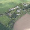
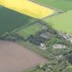
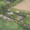
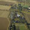
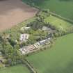
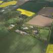
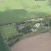
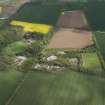
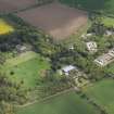
Accessibility

Font Size

100% 150% 200%

Background Colour

Default Contrast
Close Reset

Gilmerton House

Country House (18th Century)

Site Name Gilmerton House

Classification Country House (18th Century)

Canmore ID 56292

Site Number NT57NW 20

NGR NT 54919 77750

Datum OSGB36 - NGR

Permalink http://canmore.org.uk/site/56292

Ordnance Survey licence number AC0000807262. All rights reserved.
Canmore Disclaimer. © Bluesky International Limited 2025. Public Sector Viewing Terms

Toggle Aerial | View on large map

Digital Images

Oblique aerial view of East Fortune Airfield recreation area and Gilmerton House, looking NW.
Oblique aerial view of East Fortune Airfield recreation area and Gilmerton House, looking NW.Oblique aerial view of East Fortune Airfield recreation area and Gilmerton House, looking SW.Oblique aerial view of East Fortune Airfield recreation area and Gilmerton House, looking NNE.Interior view of entrance hall in Gilmerton House after fire.Drawing of Gilmerton House showing plan of bedroom floor with alterations and additions.Drawing of Gilmerton House showing South elevation with alterations and additions.Interior view of entrance hall in Gilmerton House after fire showing earlier work.General oblique aerial view looking across the country house, farmstead, airfield and museum towards North Berwick Law and the Bass Rock, taken from the SSW.Drawing of stables, Gilmerton House, showing plan of ground floor. Oblique aerial view of East Fortune Airfield recreation area and Gilmerton House, looking S.Oblique aerial view of East Fortune Airfield recreation area and Gilmerton House, looking SSE.Drawing of stables, Gilmerton House, showing plan of foundations.Drawing of Gilmerton House showing plan of ground floor with additions and alterations.Gilmerton House, NT57NW 20, Ordnance Survey index card, page number 1, RectoDrawing of Gilmerton House showing plan of drawing room floor with additions and alterations.Drawing of Gilmerton House showing section through kitchen court and East elevation of house.Oblique aerial view centred on the recreation area of the airfield with Gilmerton House adjacent, taken from the S.Interior view of entrance hall in Gilmerton House after fire.Drawing of Gilmerton House showing plan of attics.Oblique aerial view of East Fortune Airfield recreation area and Gilmerton House, looking ESE.Oblique aerial view of East Fortune Airfield recreation area and Gilmerton House, looking NE.Interior view of entrance hall in Gilmerton House after fire.Interior view of entrance hall in Gilmerton House after fire showing earlier work.Drawing of stables, Gilmerton House, showing South and West elevations.Drawing of stables, Gilmerton House, showing details of stalls and finishings.Drawing of Gilmerton House showing North elevation with alterations and additions.Oblique aerial view of East Fortune Airfield recreation area and Gilmerton House, looking W.Oblique aerial view of East Fortune Airfield recreation area and Gilmerton House, looking E.Interior view of entrance hall in Gilmerton House after fire showing signs of earlier work.Drawing of Gilmerton House showing front elevation with alterations and additions.Interior view of entrance hall in Gilmerton House after fire showing signs of earlier work.Interior view of entrance hall in Gilmerton House after fire showing signs of earlier work.Drawing of stables, Gilmerton House, showing sections.Oblique aerial view of East Fortune Airfield recreation area and Gilmerton House, looking SE.Interior view of entrance hall in Gilmerton House after fire.General oblique aerial view looking across the country house, farmstead, airfield and museum towards North Berwick Law and the Bass Rock, taken from the SSW.Drawing of stables, Gilmerton House, showing plan of roofs.Drawing of Gilmerton House showing plan of foundations and alterations.

Administrative Areas

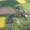
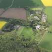
  • Council East Lothian
  • Parish Athelstaneford
  • Former Region Lothian
  • Former District East Lothian
  • Former County East Lothian

Archaeology Notes

NT57NW 20.00 54919 77750.

(NT 54919 77750) Gilmerton House (NAT)

OS 6" map (1968)

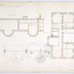
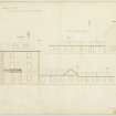
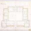
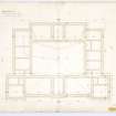
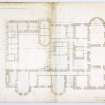
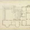
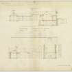
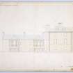
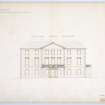
Gilmerton is a large mansion which as been altered and added to during the last two centuries.

J Small 1883

A large house, the greater part of which appears no older than the 18th c, of no great architectural merit.

Visited by OS (BS) 15 July 1975

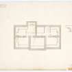
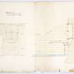
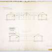
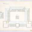
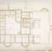
Gilmerton House was built in the 1750s for Sir David Kinloch. John Aitken was the mason. The only later additions are by William Burn in 1828.

C McWilliam 1978

Architecture Notes

NT57NW 20.00 54919 77750

NT57NW 20.01 54799 77600 Lodge and Gate Piers

NMRS REFERENCE:

Architect: William Burn 1828-29 (alterations and additions)

John Aitken - mason 1750's.

Activities

Photographic Survey (17 May 1960)

Photographic survey by the Scottish National Buildings Record/Ministry of Works in May 1960.

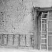
Photographic Survey (May 1962)

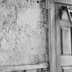
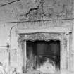
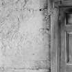
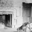
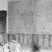
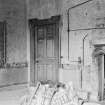
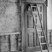
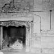
Survey of the entrance hall in Gilmerton House after a fire, East Lothian, by the Scottish National Buildings Record in 1962.

References

MyCanmore Image Contributions


Contribute an Image

MyCanmore Text Contributions