
Pricing Change
New pricing for orders of material from this site will come into place shortly. Charges for supply of digital images, digitisation on demand, prints and licensing will be altered.
Upcoming Maintenance
Please be advised that this website will undergo scheduled maintenance on the following dates:
Thursday, 9 January: 11:00 AM - 3:00 PM
Thursday, 23 January: 11:00 AM - 3:00 PM
Thursday, 30 January: 11:00 AM - 3:00 PM
During these times, some functionality such as image purchasing may be temporarily unavailable. We apologise for any inconvenience this may cause.
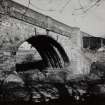
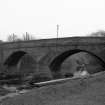
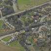
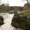
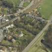
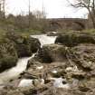
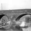
East Linton, Old Tyne Bridge


Road Bridge (16th Century)
Site Name East Linton, Old Tyne Bridge
Classification Road Bridge (16th Century)
Alternative Name(s) Linton Linn; River Tyne; Bridge End, Old Bridge; East Linton Bridge
Canmore ID 56251
Site Number NT57NE 5
NGR NT 59261 77111
Datum OSGB36 - NGR
Permalink http://canmore.org.uk/site/56251


- Council East Lothian
- Parish Prestonkirk
- Former Region Lothian
- Former District East Lothian
- Former County East Lothian
NT57NE 5 59261 77111
For (successor) New Tyne Bridge (NT 5919 7692, to S), see NT57NE 57.
For corresponding railway bridge (adjacent to S), see NT57NE 103.
(NT 5925 7710) Bridge (NR)
OS 6" map (1968)
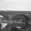
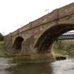
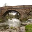
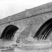
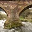
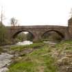
While certainly having its origin in the 16th century, and perhaps being datable substantially to the period between 1548 and 1560, this bridge has evidently undergone much alteration and numerous repairs (references to repairs occur in 1625, 1639 and 1661); the date 1763 cut on the downstream keystone of the NW arch probably refers to a widening of the bridge. The arch-rings and spandrels were tied with rods and straps and concrete laid on the extrados of the arches about 1884; the parapets were heightened about 1895, and further repairs are indicated by the date 1934 and a mason's mark carved on the downstream side of the NW abutment.
The structure now shows many irregularities of detail (described by Graham) and measures 98ft in length between its abutments; it is 18ft 9ins (5.7m) wide over the parapets, which are 3ft 7ins (1.1m) high. The carriageway is 17ft (5.2m) wide.
RCAHMS 1924; A Graham 1965.
This bridge, as described, is in a good state of repair and is in everyday use.
Visited by OS (WDJ) 20 October 1962.
(Location cited as NT 593 771). Bridge, East Linton. 16th century. A 2-span rubble bridge with segmental arches and triangular cutwaters.
J R Hume 1976.
This bridge, crossing the River Tyne at East Linton, is of two four-ribbed arches and a huge stepped cutwater, of 16th century date; its upper parts 1763 and later.
C McWilliam 1978.
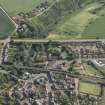
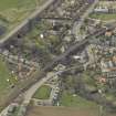
This bridge carries the former line of the A1 public road across the River Tyne within the town of East Linton (NT57NE 114).
Information from RCAHMS (RJCM), 15 October 1997.
(Name cited as Linton Linn). Descheduled.
Information from Historic Scotland, Certificate of Exclusion from Schedule dated 28 February 2000.
Modification (1762 - 1763)
Bridge widened. The original overall width across the soffit was 1012 ft, increased to nearly 14 ft when
it was widened. Other repairs took place in 1884, 1895 and 1934.
R Paxton and J Shipway 2007
Field Visit (11 July 1913)
The bridge (fig.90) at the southern end of the little town of East Linton carries the Edinburgh to Berwick highway across the River Tyne at a point where a cauld or weir is formed 70 yards above the cascade falling into the Linn Pool. The structure lies north-west and south-east and has a length of 125 feet borne on two arches over a waterway 90 feet broad. The roadway now averages 16 feet in width, but it has been widened on the south and further enlarged by the introduction of impending parapets. The arches are segmental and bear four massive ribs on their soffits. The mean span is 39 ½ feet. The present width of soffit is 13 feet 10 inches, but the original width of the soffits was 10 ½ feet. From each side of the central pier projects a cut-water with a spreading basement course carried up originally to the level of the roadway but now truncated. At the abutments are successive buttresses, on the south-east carried up to the parapet as refuges. The parapets are comparatively modern; they diverge at either end of the bridge to increase the width of the approaches. A keystone on one arch is inscribed with the date 1763, presumably the date of a reconstruction. The structure evidently dates from the 16th century and is in good condition.
HISTORICAL NOTE. Linton Bridge was the lowest convenient crossing on the Tyne and an important link in all military and civil communications via E. Lothian. Somerset brought his force across here in 1547: on Wednesday 7 Sept. they ‘came to a fayre ryuer callen Lyn . . . ouer this riuer is ther a stone bridge that they name Lynton brig,of a toun .. that stonds upon the same ryuer. Our horsmen and cariages past through .the water (for it was not very depe); our footmenouer the bridge. The passage was very straight for an army, and therefore the lengarin setting ouer’ (1). In Sept. 1549 when the English were preparing to evacuate Haddington it was reported by spies that the French ‘have overthrown Lynton bridge and are rasing it, and entrenching that passage to stop us. We cannot otherwise pass for the abundance of waters as the like hath byn seldom sen’ (2). But on March 31, 1560, Lord Grey with an English force wrote from ‘Linton briggs’, saying ‘We are now at Lintern (sic )briggis etc’(3). So it must have been reconstructed, as indeed was imperative.
RCAHMS 1924, visited 11 July 1913.
(1) Patten's Expedicion into Scotlande, p. 37 ; (2) Scot. Pap. i., p. 180; (3) Ibid. No. 705.
Modification (1927)
Relieved of trunk road traffic
Project (2007)
This project was undertaken to input site information listed in 'Civil engineering heritage: Scotland - Lowlands and Borders' by R Paxton and J Shipway, 2007.
Publication Account (2007)
A well-maintained example of a 16th century masonry bridge with buttressed abutments, ribbed arches and
pointed cutwater to the pier, dating from ca.1550. An earlier stone bridge was reported to have been razed by
the French army in 1549, but a bridge, presumably the present one, existed by 1560. The bridge, which carried the A1 Edinburgh to Berwick road until bypassed in the late 1920s, has twin arch spans of about 40 ft each, founded on exposed rock in the bed of the Tyne. There are four ribs to each arch, closely spaced, and easily inspected from outcropping rock on the downstream side. The dates 1762 and 1763 on the keystones record when it was widened. The original overall width across the soffit was 1012 ft, increased to nearly 14 ft when it was widened. Other repairs took place in 1884, 1895 and 1934. In 1927 the bridge was relieved from trunk road traffic by an elegant three-span steel plate-girder bridge of the cantilever and suspended span type with a central opening of 102 ft 8 in. designed and built by Sir William Arrol & Co. 118In the 1990s this was replaced by an embankment and culvert.
R Paxton and J Shipway 2007
Reproduced from 'Civil Engineering heritage: Scotland - Lowlands and Borders' with kind permission of Thomas Telford Publishers.

