
Hare Law


Fort (Prehistoric), Vitrified Stone (Prehistoric)
Site Name Hare Law
Classification Fort (Prehistoric), Vitrified Stone (Prehistoric)
Alternative Name(s) Harelaw
Canmore ID 56203
Site Number NT56SW 6
NGR NT 54650 63090
Datum OSGB36 - NGR
Permalink http://canmore.org.uk/site/56203


- Council East Lothian
- Parish Yester
- Former Region Lothian
- Former District East Lothian
- Former County East Lothian
NT56SW 6 54650 63090.
(NT 5465 6309) Vitrified Fort (NR)
OS 6" map (1957)
This substantial fort occupies the rocky summit of a spur on Harelaw, at 1250' OD. The summit area is bordered by the massive ruins of a timber-laced stone wall about 12' thick, which has been severely mutilated in the N by stone-robbing to provide material for the modern wall, some 4' thick at the base, which misleadingly encircles the summit. It is probable that the interior originally measured about 200' by 100'. The remains of outworks survive on the NW and SE, and especially on the SW, where the only easy approach to the fort can be made. Here two ramparts with external ditches cut off all access, and allow only a narrow pathway to extend from the hillside to the entrance of the fort, on the W.
R W Feachem 1963; RCAHMS 1924
This fort is generally as described.
Surveyed at 1:2500.
Visited by OS (WDJ) 21 September 1965 and (SFS) 15 August 1975
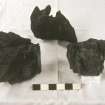
No change to previous reports. Vitrified material was found at all three points indicated by the RCAHMS (plan) particularly at the NE end of the tumbled wall.
Visited by OS (JRL) 15 June 1979
The passage entrance to this fort appears to have been constructed at the end of its occupation, possibly in the post-Roman period.
L R Laing 1975.
Field Visit (15 May 1913)
254. Hill Fort, Vitrified, Harelaw.
This fine stone fort, a little over 1 ¼ miles south of Long Yester, is built round the rocky summit at the north-eastern end of Harelaw, a spur of the Lammermuirs running in a north-easterly direction into the angle formed by the junction of the Harelaw Burn on the north and the Soon Hope Burn, a small feeder from the south. Rising to a height of almost 1250 feet above sea-level it commands an uninterrupted view of the country lying between the hills and the Firth of Forth. The site is naturally strong on all sides except towards the south-south-west, where there is a gentle ascent from the outer defence; to the north-northeast there is a rocky escarpment crowning a sharp declivity, while on the flanks the hill is very steep. The plan (fig. 185) of the interior of the fort is somewhat ear-shaped, being contracted on the eastern side some 80 feet from the narrow north-eastern end. The main axis of the fort is north-east and south-west, and the interior is 200 feet long and 86 feet broad at its widest part about 43 feet from the south south-western extremity. While at the northeastern end, where there is a strong natural defence in the rocky escarpment, only one stone wall, 34 feet above the foot of the rocks, has been considered necessary, round the flanks and opposite end the defences are more elaborate. The inner area is enclosed by a stonewall 4 feet thick and for the greater part rising about 1 ½ feet above the level of the ground on which it is built. It is in a fairly good state of preservation, except at the north-eastern end, but part of the outer facing of the foundation is in situ at the north-eastern corner. The absence of an apparent entrance through this defence, the lack of vegetation among the stones, and the clearness of its outline make it doubtful if this wall is as old as the other defences. Springing from either side of the rocks near the north-eastern end, a second stone wall and two outer ramparts of earthen circle the flanks and opposite end. Commencing about 65 feet from the north-eastern corner, and after allowing 10 feet for the entrance, the second stone wall swings out about other 20 feet and is carried in a gradually diverging line round the fort, till it reaches the rocks again on the north-west. At the south-south-western end its centre is 19 feet distant from the centre of the inner wall, and at the entrance on the north-western flank the distance is 12 feet, but beyond this to the north-east it is lost in a tumbled mass of stone. At the south-western corner there is a quantity of vitrified stones showing masses of molten matter up to 9 inches in diameter lying on what seems to be the core of the wall; while on the eastern side, where the ground has recently been disturbed, the heart of the wall is exposed, and its appearance suggests that the footing had been continuously concreted by vitrifaction. To the south of the north-western entrance and on the eastern arc the outer facing of the wall is seen for a few yards. This has been a massive wall, as the rickle of stones is as much as 30 feet in width in places; large stones are few, and the bulk of the material is of the size of causeway stones, many of which are calcined About the middle of the north western flank the main entrance is clearly defined by a shallow depression, 11 feet wide, through the outer defences and outer stone wall, and there is a suggestion of another entrance approaching the base of the rocks towards the north-east. Extending from the main entrance till it dies on the northern slopes is a short length of rampart with a ditch on either side; southwards two ramparts with ditches follow the contour of the outer stone wall round the south-western arc to the southern corner at distances from wall face to crests of 28 and 65 feet respectively. The inner rampart is 14 feet broad at base, 1 ½ feet high on the inside and 9 feet above its ditch, which is 16 feet wide; the outer is 12 feet broad at base, 4 feet high inside and the same outside above its ditch, which is 7 feet wide and 1 foot deep on the counterscarp. The ends of the outer rampart return towards the scarp of the inner, and the inner ditch has been excavated for only half the length between the ramparts, a platform being left in the southern half, in which three hollows have been dug. That towards the east is 14 feet square with a projection to the west 6 feet square making an L-shaped depression; the second chamber 30 feet to the west measures 18 feet by 8 feet, the longer axis following the line of the ditch, and the third12 feet farther on measures 12 feet by 8 feet in the same line but opens to the ditch at the west. The ramparts on the eastern flank are down on the general slope, respectively 28 and 45 feet out from the wall face; for the most part they appear as little more than scarps and are indefinite on the south-east.
RCAHMS 1924, visited 15 May 1913.
OS Map ref: xv. S.E.
Field Visit (31 May 1954)
Fort, Harelaw.
The innermost wall, 4 ft in width, is modern, and the principal defence of the fort is a stone wall which was originally about 12 ft in thickness. The existence of vitrification was confirmed at the points marked on the plan, and is clearly not attributable to any form of casual fires. In the absence of excavation it is impossible to decide whether or not the enclosing earthworks are contemporary with the wall.
Visited by RCAHMS (KAS) 31 May 1954.
Publication Account (1985)
Only the approach from the south-west is relatively easy; otherwise, the rocky 380m high summit is naturally strong, difficult to attack and commands the whole of the countryside between the Lammermuirs and the Firth of Forth.
The innermost wall, something over 1m thick and 0.5m high encircling the summit, should be taken as relatively modem, re-using stone quarried from the north end of the fort Otherwise, the kidney-shaped site runs roughly 61m by 31m, with a single stone wall around its steep north-eastern end. Around the sides, however, and especially towards the south-west, more elaborate defences were necessary. Two ramparts with external ditches cut off all access from the south-west, whilst the only entrance stands in the middle of the north-west flank-a shallow depression 3.5m wide cutting through both the outer defences and the stone inner wall.
That the massive stone wall of this fort was timberlaced is evident from traces of vitrification in parts of the walling. Almost directly opposite the entrance, vitrified stones up to 23cm diameter have been found on what seems to be the core of the inner east wall; somewhat to the south of the entrance, to the outside of the wall, more of the core has been exposed and suggests that the footing has been continuously fused by vitrification.
From Hare Law it is possible to see maybe seven or eight fortified sites within a range of 3km-5km. Kidlaw (NT 512642), Black Castle (NT 580661) and Green Castle (NT 581656) are all good examples only a short distance from a road.
Information from 'Exploring Scotland's Heritage: Lothian and Borders', (1985).
Note (14 December 2015 - 18 May 2016)
This fort occupies a local summit on the spur descending northwards from Crow Cairn on the W side of Soon Hope. The approach from the SW along the crest of the spur is very easy, but elsewhere the ground drops away sharply around a rocky spine. The defences comprise two main components, the inner a thick stone wall, which from the pieces of vitrified stone scattered round the circuit has evidently been timber-laced, and the outer up to two ramparts with external ditches blocking the SW approach and swinging round the flanks to either side. The area enclosed by the timber-laced wall has probably measured some 60m in length from NNE to SSW, and has tapered NNE from a maximum of 35m in breadth at the mid-point (0.15ha), though apart from the scree of debris along either flank little trace of the wall survives around the northern end of the spine; in part it has been robbed to build a relatively modern enclosure around the summit, but this end seems also to have suffered a catastrophic collapse down the slope. The two outer ramparts form a horseshoe-shaped arrangement around the broader SW end, returning to disappear beneath the scree along the flanks of the spine on the SE and NW respectively. At the well-defined entrance on the NW, they return and unite around the terminals of a ditch up to 5m broad, while the scree on the NE may mask a second entrance in the re-entrant formed between the ramparts and the SE flank of the spine. While essentially concentric, the two ramparts close up around this side, and there is also some evidence that they have been re-modelled on the S where the outer bifurcates, the inner, and upper, arm cutting sharply bacck towards the inner rampart, and the outer following the line of the external ditch, which on the crest of the spur is some 2m broad and 0.3m deep.
Information from An Atlas of Hillforts of Great Britain and Ireland – 18 May 2016. Atlas of Hillforts SC3867

