|
Photographs and Off-line Digital Images |
EL 3534 |
RCAHMS Aerial Photography |
Oblique aerial view. |
1977 |
Item Level |
|
|
Photographs and Off-line Digital Images |
EL 3535 |
RCAHMS Aerial Photography |
Oblique aerial view. |
1977 |
Item Level |
|
|
Photographs and Off-line Digital Images |
EL 3536 |
RCAHMS Aerial Photography |
Oblique aerial view. |
1977 |
Item Level |
|
|
Photographs and Off-line Digital Images |
EL 3540 |
RCAHMS Aerial Photography |
Oblique aerial view. |
1977 |
Item Level |
|
|
Photographs and Off-line Digital Images |
EL 4630 CS |
RCAHMS Aerial Photography |
Oblique aerial view. |
1977 |
Item Level |
|
|
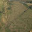
Photographs and Off-line Digital Images |
C 76366 |
RCAHMS Aerial Photography |
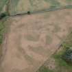
Longyester, general aerial view taken from the S, visible cropmarks include two palisaded settlements, two enclosures, two ring-ditches and a pit alignment. Other cropmarks are visible in the same field. |
22/8/1996 |
Item Level |
|
|
Photographs and Off-line Digital Images |
C 76367 |
RCAHMS Aerial Photography |
Longyester, general aerial view taken from the ESE, visible cropmarks include two palisaded settlements, two enclosures, a possible rind-ditch and a pit alignment. Other cropmarks are visible in the same field. |
22/8/1996 |
Item Level |
|
|
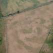
Photographs and Off-line Digital Images |
C 76368 |
RCAHMS Aerial Photography |
Longyester, general aerial view taken from the NE, visible cropmarks include two palisaded settlements, two enclosures, a possible rind-ditch and a pit alignment. Other cropmarks are visible in the same field. |
22/8/1996 |
Item Level |
|
|
Photographs and Off-line Digital Images |
C 76369 |
RCAHMS Aerial Photography |
Longyester, general aerial view taken from the N, visible cropmarks include two palisaded settlements, two enclosures, a possible rind-ditch and a pit alignment. Other cropmarks are visible in the same field. |
22/8/1996 |
Item Level |
|
|
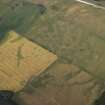
Photographs and Off-line Digital Images |
C 76360 |
RCAHMS Aerial Photography |
Longyester, oblique aerial view taken from the N, centred on the cropmarks of a rectilinear enclosure and ring-ditch. The cropmarks of a pit alignment and a palisaded settlement can be seen in the top left hand corner. |
22/8/1996 |
Item Level |
|
|
Photographs and Off-line Digital Images |
C 76361 |
RCAHMS Aerial Photography |
Longyester, oblique aerial view taken from the NW, centred on the cropmarks of a rectilinear enclosure and ring-ditch. The cropmarks of a pit alignment and a palisaded settlement can be seen in the top left hand corner. |
22/8/1996 |
Item Level |
|
|
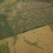
Photographs and Off-line Digital Images |
C 76371 |
RCAHMS Aerial Photography |
Longyester, general aerial view taken from the SE, the cropmarks visible include two pit alignments, three palisaded settlements, two enclosures and a possible ring ditch. Other cropmarks are visible in the same field. The cropmark of a rectilinear enclosure is visible in the top right hand corner of the photograph. |
22/8/1996 |
Item Level |
|
|
Photographs and Off-line Digital Images |
E 40303 CN |
RCAHMS Aerial Photography |
Oblique aerial view centred on the cropmarks of the pit-alignment and settlement with the cropmarks of the palisaded settlements and enclosure adjacent, taken from the N. |
22/7/2003 |
Item Level |
|
 |
On-line Digital Images |
DP 020150 |
RCAHMS Aerial Photography Digital |
Oblique aerial view centred on the cropmarks of the palisaded settlement and enclosure, taken from the WNW. |
25/7/2006 |
Item Level |
|
 |
On-line Digital Images |
DP 020151 |
RCAHMS Aerial Photography Digital |
Oblique aerial view centred on the cropmarks of the palisaded settlement, pit-alignment and enclosure and the linear cropmarks, taken from the SSW. |
25/7/2006 |
Item Level |
|
 |
On-line Digital Images |
DP 020153 |
RCAHMS Aerial Photography Digital |
Oblique aerial view centred on the cropmarks of the palisaded settlement, pit-alignment and enclosure and the linear cropmarks, taken from the W. |
25/7/2006 |
Item Level |
|
 |
On-line Digital Images |
DP 277828 |
Historic Environment Scotland |
Oblique aerial view. |
10/7/2018 |
Item Level |
|
 |
On-line Digital Images |
DP 277829 |
Historic Environment Scotland |
Oblique aerial view. |
10/7/2018 |
Item Level |
|
 |
On-line Digital Images |
SC 1744038 |
RCAHMS Aerial Photography |
Longyester, general aerial view taken from the ESE, visible cropmarks include two palisaded settlements, two enclosures, a possible rind-ditch and a pit alignment. Other cropmarks are visible in the same field. |
22/8/1996 |
Item Level |
|
|
On-line Digital Images |
AT 003482 |
Historic Environment Scotland |
Imagery and Mapping Files for Aerial Photo Transcription |
22/3/2019 |
Item Level |
|
 |
On-line Digital Images |
SC 2450536 |
Records of the Ordnance Survey, Southampton, Hampshire, England |
Longyester, NT56NE 19, Ordnance Survey index card, page number 1, Recto |
c. 1958 |
Item Level |
|
 |
On-line Digital Images |
SC 2450537 |
Records of the Ordnance Survey, Southampton, Hampshire, England |
Longyester, NT56NE 19, Ordnance Survey index card, Recto |
c. 1958 |
Item Level |
|
|
All Other |
551 166/1/1 |
Records of the Ordnance Survey, Southampton, Hampshire, England |
Archaeological site card index ('495' cards) |
1947 |
Sub-Group Level |
|


