
Lylestone Plantation


Settlement (Period Unassigned)
Site Name Lylestone Plantation
Classification Settlement (Period Unassigned)
Canmore ID 56061
Site Number NT55SW 9
NGR NT 5327 5272
Datum OSGB36 - NGR
Permalink http://canmore.org.uk/site/56061


- Council Scottish Borders, The
- Parish Lauder
- Former Region Borders
- Former District Ettrick And Lauderdale
- Former County Berwickshire
NT55SW 9 5327 5272.
(NT 5327 5272) Earthwork (NR)
OS 25" map (1965)
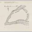
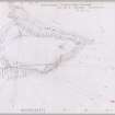
A triangular promontory enclosure, first noted by the RCAHMS (K Steer), bounded on the NW and S by the forks of a stream, junction of which forms its western apex, and on the E by a bank with external ditch, in which an entrance is centrally placed. The stream courses are deeply cut and their steep banks afford good protection. The interior platform is coarse pasture and shows no evidence of habitation.
Visited by OS (CJP) 4 October 1956
The enclosed area measures some 110.0m by 70.0m with a bank 9.0 wide and an external ditch 1.0m deep. The entrance is 3.0m wide. This is not a defensively strong site, being overlooked from N, S and E, but the strength of the bank suggests it to be a settlement rather than a simple enclosure.
Visited by OS (SFS) 21 August 1975
Field Visit (31 July 1952)
This site was included within the RCAHMS Marginal Land Survey (1950-1962), an unpublished rescue project. Site descriptions, organised by county, are available to view online - see the searchable PDF in 'Digital Items'. These vary from short notes, to lengthy and full descriptions. Contemporary plane-table surveys and inked drawings, where available, can be viewed online in most cases - see 'Digital Images'. The original typecripts, notebooks and drawings can also be viewed in the RCAHMS search room.
Information from RCAHMS (GFG) 19 July 2013.
Reference (1957)
This site is noted in the ‘List of monuments discovered during the survey of marginal land (1951-5)’ (RCAHMS 1957, xiv-xviii).
Information from RCAHMS (GFG), 24 October 2012.
Note (21 January 2016 - 17 August 2016)
This fort or fortified settlement is situated on the SW flank of Lylestone Hill, where it takes advantage of the confluence of two incised burn gullies forming a sloping promontory at the head of an unnamed tributary of the Cleekhimin Burn. Triangular on plan, it measures internally about 105m in length from ENE to WSW by a maximum of 65m transversely (0.4ha). The defences comprise a bank spread 9m in thickness, with an external ditch up to 7m in breadth, which have been drawn across the neck of the promontory on the uphill side and are pierced by a central entrance. The stature of the defences has been severely reduced by cultivation and traces of low straight rigs can be seen traversing the interior from ENE to WSW.
Information from An Atlas of Hillforts of Great Britain and Ireland – 17 August 2016. Atlas of Hillforts SC4018
Sbc Note
Visibility: This is an upstanding earthwork or monument.
Information from Scottish Borders Council

