
Pricing Change
New pricing for orders of material from this site will come into place shortly. Charges for supply of digital images, digitisation on demand, prints and licensing will be altered.
Scheduled Maintenance Notice
Please be advised that this website will undergo scheduled maintenance starting on Thursday, 30th January at 11:00 AM and will last until Friday, 31st January at 10:00 AM.
During this time, the site and certain functions may be partially or fully unavailable. We apologise for any inconvenience this may cause.
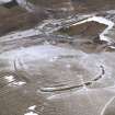
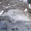
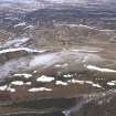
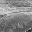
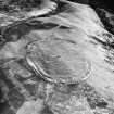
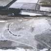
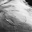
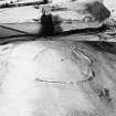
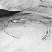
Dabshead


Fort (Prehistoric)
Site Name Dabshead
Classification Fort (Prehistoric)
Alternative Name(s) Dabshead Hill
Canmore ID 56030
Site Number NT55SW 14
NGR NT 5471 5123
Datum OSGB36 - NGR
Permalink http://canmore.org.uk/site/56030


- Council Scottish Borders, The
- Parish Lauder
- Former Region Borders
- Former District Ettrick And Lauderdale
- Former County Berwickshire
NT55SW 14 5471 5123.
(NT 5471 5123) Camp (NR)
OS 6" map (1957)
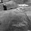
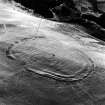
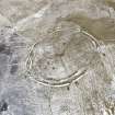
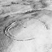
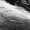
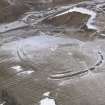
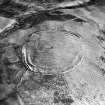
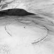
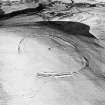
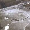
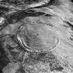
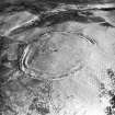
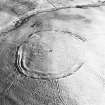
This fort measures some 600' by 435' within two concentric ramparts, with a ditch in front of each. Towards the NW where the best-preserved segment is, the defences measure 65' from the crest of the inner rampart to the crest of the counterscarp of the outer ditch. The innermost ditch is 20' wide and 6' deep; the middle rampart 15' broad across the top, having a hollow or groove running along the centre 2' deep: the outermost ditch is 22' wide and 8' below the crest of the rampart and 3' below the top of the counterscarp. The defences have been ploughed out on the centre of the NE and SW sides (see also NT55SW 22).
RCAHMS 1915, visited 1908
This fort is as described above. The likeliest entrance is in the SE, and there are two other possible entrances in the W and N sides, but other breaks in the ramparts are probably mutilations.
Resurveyed at 1:2500.
Visited by OS (RDL) 7 November 1963
No change to previous field report.
Visited by OS (SFS) 7 August 1975
There is no change in the condition of the fort except that the surviving ramparts are being heavily eroded by livestock. The fragmentary remains of the ramparts and ditches suggest that the work was never completed even allowing for the fact that the part of the defences may have been ploughed out.
Surveyed at 1/10,000.
Visited by OS (MJF) 15 May 1979
Photographed by CUCAP and RCAHMS (1980).
Field Visit (13 August 1908)
215. Hill Fort, Dabshood (O.S. ‘Dabshead’), Earnscleugh.
Situated on the summit of the hill, some 1250 feet above sea-level, is a fort (fig. 104) elliptical on plan, measuring interiorly some 600 feet by 435 feet, surrounded by two concentric ramparts with a ditch in front of each. Towards the north-west, in which direction lies the best preserved segment, the defences measure 65 feet across from the crest of the inner rampart to the crest of the counterscarp of the outer ditch. The innermost ditch is 20 feet wide and 6 feet deep; the middle rampart 15 feet broad across the top, having a hollow or groove running along the centre 2 feet deep; while the outermost ditch is 22 feet wide and 8 feet deep below the crest of the rampart and 3 feet below the top of the counterscarp. The elevation of the inner rampart is trifling. On the centre of the north-east and south-westsides the defences have been obliterated by ploughing.
See Antiquaries, xxix. p. 134 (secs.).
RCAHMS 1915, visited 13th August 1908.
OS Map: Ber., xiv. SW.
Field Visit (31 August 1950)
This site was included within the RCAHMS Marginal Land Survey (1950-1962), an unpublished rescue project. Site descriptions, organised by county, are available to view online - see the searchable PDF in 'Digital Items'. These vary from short notes, to lengthy and full descriptions. Contemporary plane-table surveys and inked drawings, where available, can be viewed online in most cases - see 'Digital Images'. The original typecripts, notebooks and drawings can also be viewed in the RCAHMS search room.
Information from RCAHMS (GFG) 19 July 2013.
Note (22 January 2016 - 31 August 2016)
This fort is situated on the summit of Dabshead Hill, which forms the the southern bastion of the hills at the mouth of the valley of the Earnscleugh Water. Oval on plan, it measures about 185m from NW to SE by 135m transversely within twin ramparts with external ditches forming a belt some 23m in depth, but the whole of the interior and the inner rampart have been heavily ploughed during the post-medieval period parts, and in two places, on the NE and SW respectively the defences have been all but levelled, while elsewhere substantial field-banks have been superimposed upon the circuit. The interior is thus featureless, while the gap in the defences on the NE possibly marks the position of an entrance. A standing stone set up as a memorial in the centre of the interior bears five cupmarks and was moved here from somewhere N of the stone circle on Borrowstone Rig.
Information from An Atlas of Hillforts of Great Britain and Ireland – 31 August 2016. Atlas of Hillforts SC4020

