Pricing Change
New pricing for orders of material from this site will come into place shortly. Charges for supply of digital images, digitisation on demand, prints and licensing will be altered.
Upcoming Maintenance
Please be advised that this website will undergo scheduled maintenance on the following dates:
Thursday, 9 January: 11:00 AM - 3:00 PM
Thursday, 23 January: 11:00 AM - 3:00 PM
Thursday, 30 January: 11:00 AM - 3:00 PM
During these times, some functionality such as image purchasing may be temporarily unavailable. We apologise for any inconvenience this may cause.
Hog Hill
Settlement (Period Unassigned)
Site Name Hog Hill
Classification Settlement (Period Unassigned)
Canmore ID 55968
Site Number NT55NW 11
NGR NT 5239 5500
Datum OSGB36 - NGR
Permalink http://canmore.org.uk/site/55968
- Council Scottish Borders, The
- Parish Lauder
- Former Region Borders
- Former District Ettrick And Lauderdale
- Former County Berwickshire
NT55NW 11 5239 5500
(NT 5239 5500) Old Sheepfold (NAT)
OS 6" map (1862).
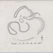
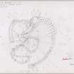
The wasted remains of a homestead measuring externally 90ft N-S by 100ft transversely are situated on the SW side of Hog Hill. It has been enclosed by a boulder-faced rubble wall about 6ft thick, from which all the facing stones have been robbed; on the SE it has been entirely removed and replaced by a modern wall, itself now ruinous. Gaps in the W and NW may represent original entrances.
The interior, which slopes SW, contains three scooped courts arranged round a central platform. (Though noted as a homestead in 1952, this would now be described by the RCAHMS as a settlement - c/f examples in Peeblesshire inventory).
RCAHMS MS, visited 1952
An oval enclosure, 37.0m by 25.0m. The S segment has totally collapsed; it was dry-stone built. The entrance is in the SW. There are traces of four circular depressions within the enclosure, in which, and on the slope of the hill, is a profusion of stones.
Visited by OS (JD), 12 May 1955
Generally as described in the previous field report, except that the enclosure is more circular on plan, 29.0m in average diameter, OS (JD) having included a disturbed area immediately NW of the site as forming part of it. The disturbed area includes a circular depression, but bracken obscures this part of the site. Only two circular depressions, 8.0m in diameter and 0.2m deep, may be seen in the interior, with indications of a third, larger depression on the E. This is probably a settlement.
Surveyed at 1/2500.
Visited by OS (RDL), 1 November 1963
A sub-circular homestead measuring 30.0m in average diameter. It is generally as described by the RCAHMS but has a fourth court just outside the modern wall on the south-east.
Surveyed at 1/10,000.
Visited by OS (BS), 16 May 1979.
Field Visit (14 August 1952)
This site was included within the RCAHMS Marginal Land Survey (1950-1962), an unpublished rescue project. Site descriptions, organised by county, are available to view online - see the searchable PDF in 'Digital Items'. These vary from short notes, to lengthy and full descriptions. Contemporary plane-table surveys and inked drawings, where available, can be viewed online in most cases - see 'Digital Images'. The original typecripts, notebooks and drawings can also be viewed in the RCAHMS search room.
Information from RCAHMS (GFG) 19 July 2013.
Reference (1957)
This site is noted in the ‘List of monuments discovered during the survey of marginal land (1951-5)’ (RCAHMS 1957, xiv-xviii).
Information from RCAHMS (GFG), 24 October 2012.
Sbc Note
Visibility: This is an upstanding earthwork or monument.
Information from Scottish Borders Council


