
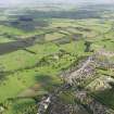
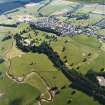
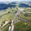
Lauder, General


Burgh (Medieval), Town (Period Unassigned)
Site Name Lauder, General
Classification Burgh (Medieval), Town (Period Unassigned)
Canmore ID 55883
Site Number NT54NW 54
NGR NT 53047 47606
NGR Description Centred on NT 53047 47606
Datum OSGB36 - NGR
Permalink http://canmore.org.uk/site/55883


- Council Scottish Borders, The
- Parish Lauder
- Former Region Borders
- Former District Ettrick And Lauderdale
- Former County Berwickshire
NT54NW 54 53 47.
(Incorporates deleted no )
Lauder is traditionally said to have been a royal burgh, erected by William the Lion, 1298 x 1328. However, there are objections to this, and it seems likely that Lauder, if it was not a 13th-century burgh, became a burgh only after being granted to Sir James Douglas, 1324 x 1325. Lauder was dependent on the earls of Douglas until the forfeiture of 1455.
G S Pryde 1965.
EXTERNAL REFERENCE:
Gauche view of Lauder by Maurer(?), c.1760's, hanging in Thirlestane Castle
Watching Brief (9 March 2016)
AOC Archaeology Groups was commissioned to undertake an archaeological watching brief on the topsoil strip for single storey house extension at 5 East High Street, Lauder.
The works were conducted under ideal archaeological conditions in a single phase of works on 9th March 2016. The excavations were no more than 0.40 m deep and between 0.80 m to 0.90 m. In total c.12.0 m of foundation was excavated. No significant features or artefacts were revealed during the archaeological works.

