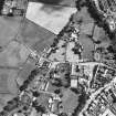
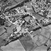
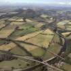
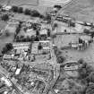
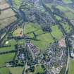
Accessibility

Font Size

100% 150% 200%

Background Colour

Default Contrast
Close Reset

Melrose, General

Burgh (Medieval), Town (Period Unassigned)

Site Name Melrose, General

Classification Burgh (Medieval), Town (Period Unassigned)

Canmore ID 55760

Site Number NT53SW 50

NGR NT 5477 3397

NGR Description Centred on NT 5477 3397

Datum OSGB36 - NGR

Permalink http://canmore.org.uk/site/55760

Ordnance Survey licence number AC0000807262. All rights reserved.
Canmore Disclaimer. © Bluesky International Limited 2025. Public Sector Viewing Terms

Toggle Aerial | View on large map

Digital Images

General oblique aerial view with the railway viaduct in the foreground and the village, town and remains of the fort in the distance, taken from the NE.
General oblique aerial view with the railway viaduct in the foreground and the village, town and remains of the fort in the distance, taken from the NE.Oblique aerial view centred on Melrose railway station, taken from the SE.Oblique aerial view centred on the centre of the town, taken from the NNE.Oblique aerial view centred on the centre of the town, taken from the N.Oblique aerial view of Dingleton, Melrose, looking NE.View of entrance front of Abbotswear shop.General oblique aerial view centred on Harmony house and the remains of the abbey, taken from the NW.General oblique aerial view centred on the cropmarks of the Roman fort and Roman temporary camps with the town, village and remains of the fort in the distance and the railway viaduct and road bridge in the foreground, taken from the NE.General oblique aerial view centred on the cropmarks of the Roman fort and Roman temporary camps with the town, village and remains of the fort in the distance and the railway viaduct and road bridge in the foreground, taken from the NE.Oblique aerial view centred on the Abbey, taken from the E.Oblique aerial view centred on Melrose railway station, taken from the SW.Oblique aerial view of Melrose centred on Harmony house and the remains of the abbey, taken from the N.Oblique aerial view centred on abbey from NW.Oblique aerial view centred on the centre of the town, taken from the E.Oblique aerial view centred on the centre of the town, taken from the NE.Oblique aerial view centred on the centre of the town, taken from the SW.Oblique aerial view of Dingleton, Melrose, looking NE.Oblique aerial view centred on abbey from SE.Oblique aerial view centred on abbey from E.General oblique aerial view centred on the remains of the fort and the Eildon Hills with the town in the foreground, taken from the NNW.Oblique aerial view centred on the Abbey, taken from the SSE.General oblique aerial view centred on the town, taken from the NE.Oblique aerial view of Dingleton, Melrose, looking E.Distant view of Melrose from the south west.
Titled: 'Melrose from S.W. 421 J.V.'
PHOTOGRAPH ALBUM No 25: MR DOG ALBUMOblique aerial view centred on abbey from N.Oblique aerial view centred on town from NE.Melrose, General, NT53SW 50, Ordnance Survey index card, page number 1, RectoGeneral oblique aerial view centred on the remains of the fort and the Eildon Hills with the town in the foreground, taken from the N.Oblique aerial view of Dingleton, Melrose, looking W.General oblique aerial view of Melrose centred on Harmony house and the remains of the abbey, taken from the SE.Oblique aerial view centred on abbey from W.Oblique aerial view centred on abbey from NE.Oblique aerial view centred on town from S.Melrose, General view from West, Melrose parishMelrose, General, NT53SW 50, Ordnance Survey index card, RectoOblique aerial view centred on abbey from E.Oblique aerial view centred on abbey from WSW.Oblique aerial view centred on the cropmarks of Newstead Roman fort and Roman temporary camps with Melrose town and remains of the Eildon Hill North fort in the distance and the Leaderfoot railway viaduct and road bridge in the foreground, taken from the NE. The viaduct is no longer in use.General oblique aerial view centred on the town, taken from the NE.Oblique aerial view of Dingleton, Melrose, looking NNE.Oblique aerial view of Dingleton, Melrose, looking W.Oblique aerial view of Dingleton, Melrose, looking SW.Oblique aerial view of Dingleton, Melrose, looking SW.Oblique aerial view of Dingleton, Melrose, looking SW.Oblique aerial view of Dingleton, Melrose, looking SE.Oblique aerial view of Dingleton, Melrose, looking E.General oblique aerial view of Melrose centred on Harmony house and the remains of the abbey, taken from the SE.Oblique aerial view centred on abbey from N.General oblique aerial view centred on the cropmarks of the Roman fort and Roman temporary camps with the town, village and remains of the fort in the distance and the railway viaduct and road bridge in the foreground, taken from the NNE.General oblique aerial view with the railway viaduct in the foreground and the village, town and remains of the fort in the distance, taken from the NE.Oblique aerial view centred on Melrose railway station, taken from the NE.Oblique aerial view centred on the centre of the town, taken from the NW.Oblique aerial view centred on the centre of the town, taken from the WSW.Watercolour landscape of Melrose with Abbey in the distance.Oblique aerial view of Dingleton, Melrose, looking NE.Oblique aerial view of Dingleton, Melrose, looking NW.Oblique aerial view centred on abbey from E.Oblique aerial view.Oblique aerial view centred on town from SW.Oblique aerial view centred on abbey from SSW.Oblique aerial view of Dingleton, Melrose, looking WSW.Oblique aerial view of Dingleton, Melrose, looking WNW.Oblique aerial view of Dingleton, Melrose, looking WNW.General oblique aerial view centred on Harmony house and the remains of the abbey, taken from the SW.Oblique aerial view centred on abbey from S.Aerial view.Oblique aerial view centred on abbey from SSW.Oblique aerial view centred on abbey from WSW.

Administrative Areas

  • Council Scottish Borders, The
  • Parish Melrose
  • Former Region Borders
  • Former District Ettrick And Lauderdale
  • Former County Roxburghshire

Archaeology Notes

NT53SW 50 5477 3397

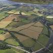
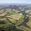
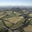
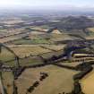
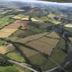
The extent of the burgh of Melrose (NT 54 33) was defined by a boundary ditch called 'Tonman's Dyke', which may have been defensible. The ditch existed in the 12th century, and possibly goes back to the time of the foundation of the town. In later times crosses were erected at the entrances to the town and at the points where the direction of the boundary changed. The original name was 'Little Fordell'.

J Curle 1935

Mentioned as burgh of barony in 1605; re-erected burgh of barony in 1609; became a burgh of regality in 1621.

G S Pryde 1965.

Architecture Notes

NT53SW 50 5477 3397 Centre

NMRS REFERENCE

Collection items LOR M/41/1 and LOR J/3/1/1-5 (Robert and Dorothea Mary Jeffrey Memorial) have been entered in this general site because at time of entry it was not possible to determine in which of the churchyards in Melrose the memorial is located (AC 7 May 2002).
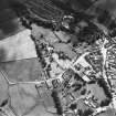
References

MyCanmore Image Contributions


Contribute an Image

MyCanmore Text Contributions