
Newstead


Settlement (Iron Age)
Site Name Newstead
Classification Settlement (Iron Age)
Canmore ID 55709
Site Number NT53SE 95
NGR NT 56914 33685
Datum OSGB36 - NGR
Permalink http://canmore.org.uk/site/55709


- Council Scottish Borders, The
- Parish Melrose
- Former Region Borders
- Former District Ettrick And Lauderdale
- Former County Roxburghshire
NT53SE 95 NT 56915 33685
See also NT53SE 20.00.
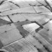
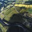
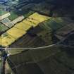
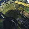
Earthwork. Within the SW quadrant of the fourth of the temporary camps mentioned above, and on the same ridge as is occupied by the roadside post, air-photography has revealed the S half of an earthwork possibly a native fort. No remains are visible on the ground, but the air-photographs suggest that it was a double-ditched, broadly-oval work measuring about 360ft by 330ft overall.
RCAHMS 1956, visited 1947
The ditches were sectioned by R F J Jones in 1990, and a trench 20m square was excavated in the interior. This revealed a timber round-house and extensive stone surfaces. Finds included Iron Age pottery and a bronze bracelet; late Flavian rusticated sherds were found under a collapsed stone wall, confirming occupation into the Roman period.
S S Frere 1991.
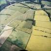
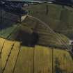
NT 569 336 In 1993 K Clark from the Newstead Research Project surveyed Red Rig. Geophysical survey was undertaken on three of the four fields under which Red Rig enclosure currently lies. Resistivity survey was completed on the two southern fields, and magnetometry was completed on all but the northwestern fields. Both surveys provide evidence for a double ditched sub-circular enclosure.
Sponsors: National Museums of Scotland, University of Bradford, British Academy, Borders Regional Council.
A L Wise 1995.
Project (1993)
NT 569 336 In 1993 K Clark from the Newstead Research Project surveyed Red Rig. Geophysical survey was undertaken on three of the four fields under which Red Rig enclosure currently lies. Resistivity survey was completed on the two southern fields, and magnetometry was completed on all but the northwestern fields. Both surveys provide evidence for a double ditched sub-circular enclosure.
Sponsors: National Museums of Scotland, University of Bradford, British Academy, Borders Regional Council.
A L Wise 1995.
Note (21 August 2015 - 31 May 2016)
Cropmarks have revealed what is probably a fortified settlement on a low spur that descend gently E to the S of the Roman fort complex at Nestead. Oval on plan, it measures about 80m from N to S by 70m transversely (0.4ha) within two ditches set about 5m apart; the ditches appear relatively narrow at about 2m in breadth. The ditches were sectioned in 1990 and within the interior a timber round-house and stone surfaces were uncovered; finds included Roman pottery from beneath a collapsed wall, as well as other coarse pottery and a bronze bracelet (Frere 1991), but the full results of this work remain unpublished.
Information from An Atlas of Hillforts of Great Britain and Ireland – 31 May 2016. Atlas of Hillforts SC3328
Sbc Note (21 March 2016)
Visibility: This was the site of an archaeological monument, which may no longer be visible.
Information from Scottish Borders Council
Previously also listed under duplicate site NT96SW 510 -CANCELLED. HES (LCK) 11.6.2024

