
Pricing Change
New pricing for orders of material from this site will come into place shortly. Charges for supply of digital images, digitisation on demand, prints and licensing will be altered.
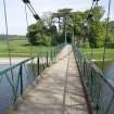
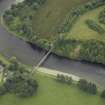
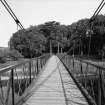
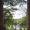
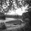
Dryburgh, Suspension Bridge


Suspension Bridge (20th Century), Suspension Bridge (19th Century)
Site Name Dryburgh, Suspension Bridge
Classification Suspension Bridge (20th Century), Suspension Bridge (19th Century)
Alternative Name(s) River Tweed; Bridge Stream; Dryburgh Abbey, Old Iron Chain Bridge; Dryburgh Abbey Footbridge; Dryburgh Mains
Canmore ID 55698
Site Number NT53SE 84
NGR NT 58857 32090
NGR Description NT c. 58859 32047 to NT c. 58861 32119
Datum OSGB36 - NGR
Permalink http://canmore.org.uk/site/55698


- Council Scottish Borders, The
- Parish Mertoun
- Former Region Borders
- Former District Ettrick And Lauderdale
- Former County Berwickshire
NT53SE 84 58857 32090
Suspension Bridge (Foot) [NAT]
OS 1:10,000 map, 1992.
Location formerly cited as NT 5885 3209.
NMRS REFERENCE:
Architect: John and Thomas Smith, 1817
EXTERNAL REFERENCE:
Scottish Record Office:
GD/157/2009
The chain bridge, sketch 1817
GD/157/2019
Pen sketch, 1817
RIBA Drawings Collection
Plan and elevation - John and Thomas Smith, 1817
Gentleman's Magazine, 1817-18: LXXXVII, p.175; LXXXVIII, p.268, 367
(Undated) information in NMRS.
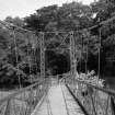
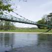
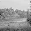
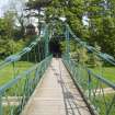
(Suspension bridge of wire rope and truss deck type: location cited as NT 588 321). 20th century. Wire-rope cables (two on each side), rod suspenders, lattice truss span, wooden deck. Span about 250 ft (76.2m). Public footbridge.
J R Hume 1977b.
This suspension bridge was designed by John Smith, and built in 1817; it was blown down but successfully re-erected in 1818. It was blown down again and replaced in 1850.
C A Strang 1994.
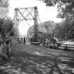
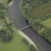
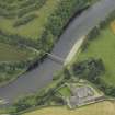
This bridge carries a footpath across the River Tweed to the SW of Dryburgh Mains steading (NT53SE 219) and within the area known as Bridge Stream. The river here forms the boundary between the parishes of Mertoun (to the N) and St Boswells (to the S).
The location assigned to this record defines the centre of the span. The available map evidence indicates that the bridge extends from NT c. 58859 32047 to NT c. 58861 32119.
The chronology and extent of the successive reconstructions of this structure remain unclear.
Information from RCAHMS (RJCM), 13 January 2006.
Dryburgh Suspension Bridge. The first chain bridge in Scotland, being built in 1817 by Thomas Smith, with a wooden platform suspended from iron chains. It was twice reconstructed, first after a gale in 1818 'on a new and more elegant plan' by the Smiths, and again in 1872, when firm posts were placed along the walkway, with a strong wire rope attached to each post and fixed in the centre of the bridge.
K Cruft, J Dunbar and R Fawcett 2006.
Construction (1817)
Construction of first bridge on site. Wrought iron suspension and chain stay bridge. Rod-end failure meant rebuild following year.
Construction (1818)
Wrought iron chain link suspension bridge replacement of 1817 bridge.
Project (2007)
This project was undertaken to input site information listed in 'Civil engineering heritage: Scotland - Lowlands and Borders' by R Paxton and J Shipway, 2007.
Publication Account (2007)
A steel wire cable suspension bridge erected over the Tweed near the Abbey in 1911 with a span of about 260 ft and steel-lattice tower supports. It was refurbished, including re-decking, in the early 1990s, having replaced
the wrought-iron chain-link suspension footbridge of similar span of 1818. It too had replaced a pioneering
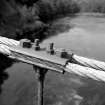
bridge of the suspension and chain-rod stay type, August 1817, which had collapsed in a storm from chain failure at its rod ends (as shown). Both were designed, made and erected by J. & T. Smith of Darnick for the Earl of Buchan.
R Paxton and J Shipway 2007
Reproduced from Civil engineering heritage: Scotland - Lowlands and Borders' with kind permission from Thomas Telford Publishers.
Sbc Note (15 April 2016)
Visibility: Standing structure or monument.
Information from Scottish Borders Council

